Tengboche
 |
|
| Localització |
|---|
 | | 27° 50′ 10″ N, 86° 45′ 50″ E / 27.8361°N,86.7639°E / 27.8361; 86.7639 |
|
|
|
| Estat sense litoral | Nepal |
| Província | Província núm. 1 |
| Districte | Districte de Solukhumbu |
| Municipi rural | Khumbu Pasanglhamu (en)   |
| |
| |
| Geografia |
|---|
| Banyat per | Imja Khola (en) |
|---|
| Altitud | 3.867 m |
|---|
|
|
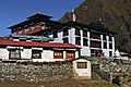
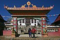
Tengboche (o Thyangboche) és una població a Khumjung en la regió Khumbu del Nepal nord-oriental, situada a 3,867 metres (12,687 ft) d'altitud. En aquesta població hi ha un monestir budista important Monestir de Tengboche. Tengboche té una vista paronàmica de l'Himàlaia, incloent els pics de Tawache, Everest, Nuptse, Lhotse, Ama Dablam, i Thamserku.[1]
Referències
- ↑ Ortner, Sherry B.. Life and Death on Mt. Everest: Sherpas and Himalayan Mountaineering. Princeton University Press, 2001, p. 112. ISBN 0-691-07448-8.
Enllaços externs
- Video Guide to Tengboche
- Official website of the Tengboche Monastery
- Nepal Himalayas Arxivat 2012-10-04 a Wayback Machine.
- Tengboche on the Everest Trek
- The Buddhist Dance Drama of Tengboche Arxivat 2009-02-07 a Wayback Machine.