St. Paul’s (St. Helena)
| St. Paul’s | |||
|---|---|---|---|
| |||
| Koordinaten | 15° 57′ 5″ S, 5° 43′ 21″ W-15.951389-5.7225Koordinaten: 15° 57′ 5″ S, 5° 43′ 21″ W | ||
 | |||
| Basisdaten | |||
| Staat | St. Helena, Ascension und Tristan da Cunha | ||
| Insel | Insel St. Helena | ||
| ISO 3166-2 | SH-HL | ||
| Fläche | 11,4 km² | ||
| Einwohner | 928 (2021) | ||
| Dichte | 81,4 Ew./km² | ||


St. Paul’s ist ein Distrikt und eine Ansiedlung auf St. Helena. Der Distrikt St. Paul’s hat 928 Einwohner (Stand 2021)[1] auf einer Fläche von 11,4 Quadratkilometern.
Neben der gleichnamigen Hauptansiedlung befinden sich mit Francis Plain und Scotland zwei weitere Ansiedlungen in dem Distrikt. Mit der Schule Prince Andrew hat St. Paul’s die einzige weiterführende Schule der Insel.
Touristisches
St. Paul’s ist einer der touristisch wichtigsten Distrikte der Insel. Hier befinden sich unter anderem:
- Plantation House, der Sitz des Gouverneurs von St. Helena
- St. Paul’s Cathedral
- High Knoll Fort
- Prince’s Lodge
- Lemon Valley, ein historisches Landschaftsschutzgebiet
- Jonathan, ältester Bewohner der Insel und das älteste lebende Reptil der Welt
- Farm Lodge Hotel, eine touristische Unterkunft
Francis Plain verfügt über den einzigen Cricket- und Fußballplatz der Insel.
Sakralbauten
- St. Paul’s Cathedral
- St. Martin-in-the-Hills Church
- St Helena Baptist Church
- Knollcombe Chapel mit dem Buren-Krieg-Friedhof
Galerie
-
 St. Paul’s Cathedral
 -
 Plantation House
 -
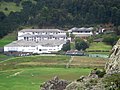 Prince Andrew-Schule
 -
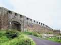 High Knoll Fort
 -
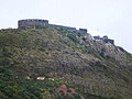 High Knoll Fort
 -
 St. Martin-in-the-Hills Church
 -
 Knollcombe Chapel


Weblinks
- In & around St Paul’s. Offizielle touristische Informationen. In: Explore St Helena – Visitor Guide. St Helena Tourism, Januar 2014, S. 21 (PDF; 3,86 MB, englisch).
- St Pauls – the heartland of St Helena. Informationsseite mit Fotos. In: Saint Helena Island Info: All about St Helena, in the South Atlantic Ocean. John Turner (englisch).
- St Paul’s; St Helena Island. Topographische Karte 1:20.000. In: gis-sthelena.gov.sh, Geospatial Information, Mapping and Survey Systems (GIS) St Helena (PDF; 162 kB, englisch).
Einzelnachweise
- ↑ The Population and Housing Census 2021 - Final Results. The St Helena Independent. Jahrgang 16, Ausgabe 35, S. 11. (PDF)


