Ahtanum Ridge
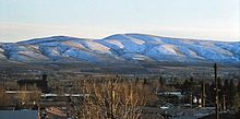
Ahtanum Ridge is a long anticline mountain ridge in Yakima County in the U.S. state of Washington. It is located just south of the city of Yakima, and much of its length is at the northern edge of the Yakama Indian Reservation. Its name comes from the Sahaptin toponym [átanɨm].[1]
Ahtanum Ridge is part of the Yakima Fold Belt of east-tending long ridges formed by the folding of Miocene Columbia River basalt flows.[2]
Ahtanum Ridge separates Yakima Valley on the south from Ahtanum Valley on the north. At the eastern end of Ahtanum Ridge the Yakima River flows through Union Gap. The ridge continues east of Union Gap as the Rattlesnake Hills.
References
External links
Wikimedia Commons has media related to Ahtanum Ridge.
- U.S. Geological Survey Geographic Names Information System: Ahtanum Ridge
46°30′25″N 120°48′56″W / 46.50694°N 120.81556°W / 46.50694; -120.81556
- v
- t
- e
Washington hills and ridges
Washington
| Yakima Fold Belt |
|
|---|---|
| Steptoes | |
| Other |
Washington
| Pacific Coast Ranges incl. Olympic Mountains foothills |
|
|---|---|
| Other |
|
List of mountain ranges in Washington
 | This Yakima County, Washington state location article is a stub. You can help Wikipedia by expanding it. |
- v
- t
- e


