Anivorano Nord
Place in Diana, Madagascar
Anivorano Nord Anivorano Avaratra | |
|---|---|
 Anivorano-Nord | |
| 12°44′S 49°14′E / 12.733°S 49.233°E / -12.733; 49.233 | |
| Country |  Madagascar Madagascar |
| Region | Diana |
| District | Antsiranana II |
| Elevation [1] | 440 m (1,440 ft) |
| Population (2018)Census | |
| • Total | 24,838 |
| Time zone | UTC3 (EAT) |
| Postal code | 202 |
Anivorano Nord or Anivorano Avaratra is a municipality in Madagascar. It belongs to the district of Antsiranana II, which is a part of Diana Region.
Primary and junior level secondary education are available in town. It is also a site of industrial-scale mining. The majority 99% of the population are farmers. The most important crop is rice, while other important products are peanut and maize. Services provide employment for 1% of the population.[2]
Geography
Anivorano Nord is situated at the Route nationale 6 at 69 km from Diego Suarez. Next towns are Ambilobe and Andrafiabe.[3]
Bodies of water
The Antanavo Lake & the Beamalona River are situated in this municipality.
Gallery
-
 The town hall
 -
 National road 6
 -
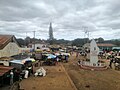 The market
 -
 Beamalona River


References
- ^ Estimated based on DEM data from Shuttle Radar Topography Mission
- ^ "ILO census data". Cornell University. 2002. Retrieved 2008-02-13.
- ^ Atlas Mondial, France Loisir, page 159
Wikimedia Commons has media related to Anivorano-Nord.
- v
- t
- e
- Ambalahonko
- Ambanja
- Ambaliha
- Ambodimanga
- Ambohimarina
- Ambohimena
- Ambohitrandriana
- Ankatafa
- Ankingameloko
- Anorotsangana
- Antafiambotry
- Antranokarany
- Antsakoamanondro
- Antsahabe (Ambanja)
- Antsatsaka
- Antsirabe
- Bemanevika Haut Sambirano
- Bemaneviky Ouest
- Benavony
- Djangoa
- Maevatanana, Diana
- Maherivaratra
- Marotolana
- Marovato

- Ambolobozobe
- Ambondrona
- Andrafiabe
- Andranofanjava
- Andranovondronina
- Anivorano Nord
- Ankarangona
- Anketrakabe
- Anivorano Nord
- Antanamitarana
- Antsahampano
- Antsalaka
- Antsiranana II
- Antsoha
- Bobakilandy
- Bobasakoa
- Joffreville
- Mahalina
- Mahavanona
- Mangaoka
- Mosorolava
- Ramena
- Sadjoavato
- Sakaramy
- Nosy Be
- Ambatozavavy
- Ampangorina
- Befotaka, Nosy Be
- Dzamandzar
5 districts; 51 communes
12°44′S 49°14′E / 12.733°S 49.233°E / -12.733; 49.233
 | This Diana Region of Madagascar location article is a stub. You can help Wikipedia by expanding it. |
- v
- t
- e


