Barras, Cumbria
Hamlet in Cumbria, England
Human settlement in England
- Stainmore
- Eden
- Cumbria
- North West
- Penrith and The Border
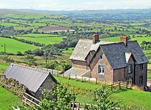
Barras is a hamlet close to the River Belah, about 4 miles (6 kilometres) south-east of Brough, Cumbria, England.[1][2]
Until the creation of the new county of Cumbria, Barras was situated at the eastern edge of the historic county of Westmorland.
The hamlet is located at approximately 1,100 feet (340 metres) above sea level.
From 1861 until 1962 it was served by Barras railway station on the Stainmore railway line between Kirkby Stephen and Barnard Castle.
References
Wikimedia Commons has media related to Barras, Cumbria.
- v
- t
- e


