Brehov
Village in Košice Region of Slovakia
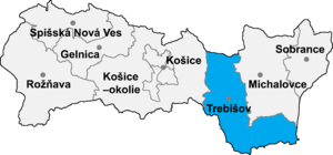
Brehov (Slovak pronunciation: [ˈbreɦɔw]; Hungarian: Imreg) is a village and municipality in the Trebišov District in the Košice Region of eastern Slovakia.
History
In historical records the village was first mentioned in 1309. A convent of Franciscans friars was founded in 1752.
Geography
The village lies at an altitude of 130 metres and covers an area of 7.901 km². It has a population of about 640 people.
Ethnicity
The village is approximately 45% Hungarian and 55% Slovak.
Facilities
The village has a public library and a football pitch.
Genealogical resources
The records for genealogical research are available at the state archive "Statny Archiv in Kosice, Slovakia"
- Roman Catholic church records (births/marriages/deaths): 1752–1902 (parish A)
- Greek Catholic church records (births/marriages/deaths): 1772–1895 (parish B)
- Reformated church records (births/marriages/deaths): 1816–1895 (parish B)
See also
External links
- https://web.archive.org/web/20070513023228/http://www.statistics.sk/mosmis/eng/run.html
- Convent of Franciscans friars in Brehov
- Surnames of living people in Brehov
- v
- t
- e
Municipalities of Trebišov District
- Čierna nad Tisou
- Kráľovský Chlmec
- Sečovce
- Trebišov
- Bačka
- Bačkov
- Bara
- Biel
- Boľ
- Borša
- Boťany
- Brehov
- Brezina
- Byšta
- Cejkov
- Čeľovce
- Čerhov
- Černochov
- Čierna
- Dargov
- Dobrá
- Dvorianky
- Egreš
- Hraň
- Hrčeľ
- Hriadky
- Kašov
- Kazimír
- Klin nad Bodrogom
- Kožuchov
- Kravany
- Kuzmice
- Kysta
- Ladmovce
- Lastovce
- Leles
- Luhyňa
- Malá Tŕňa
- Malé Ozorovce
- Malé Trakany
- Malý Horeš
- Malý Kamenec
- Michaľany
- Nižný Žipov
- Novosad
- Nový Ruskov
- Parchovany
- Plechotice
- Poľany
- Pribeník
- Rad
- Sirník
- Slivník
- Slovenské Nové Mesto
- Soľnička
- Somotor
- Stanča
- Stankovce
- Strážne
- Streda nad Bodrogom
- Svätá Mária
- Svätuše
- Svinice
- Trnávka
- Veľaty
- Veľká Tŕňa
- Veľké Ozorovce
- Veľké Trakany
- Veľký Horeš
- Veľký Kamenec
- Viničky
- Višňov
- Vojčice
- Vojka
- Zatín
- Zbehňov
- Zemplín
- Zemplínska Nová Ves
- Zemplínska Teplica
- Zemplínske Hradište
- Zemplínske Jastrabie
- Zemplínsky Branč

48°29′N 21°49′E / 48.483°N 21.817°E / 48.483; 21.817
Authority control databases | |
|---|---|
| International |
|
| National |
|
 | This article relating to the geography of the Trebišov District is a stub. You can help Wikipedia by expanding it. |
- v
- t
- e


