Circuito Norte
     1-1: Mantua to Arroyo de Mantua Junction 4-321: Entronque Vueltas to Caibarien 4-123: Sancti Spíritus Province 5-123: Ciego de Avila and Camagüey Province 6-123: Puerto Padre to Baracoa | |
|---|---|
| Northern Circuit | |
 Map of the CN highlighting, in dark red, the motorways "Vía Blanca" and "Panamericana", both part of its route | |
 The CN across the municipality of Bolivia | |
| Route information | |
| Length | 1,222 km (759 mi) |
| Major junctions | |
| West end |  1–1 (Mantua) 1–1 (Mantua) |
| Major intersections |  Autopista ZEDM (Mariel) Autopista ZEDM (Mariel)   I–3 Autopista A2 / Vía Monumental / Vía Blanca (Habana del Este) I–3 Autopista A2 / Vía Monumental / Vía Blanca (Habana del Este)  Carretera Central (Matanzas) Carretera Central (Matanzas) I–3 Autopista Sur (Varadero) Cayo Santa María Causeway  5-445 Holguín Beltway (in Holguín, to CC) 5-445 Holguín Beltway (in Holguín, to CC) |
| East end | Carretera Central (Baracoa) |
| Location | |
| Country | Cuba |
| Major cities | Mantua, Mariel, Havana, Santa Cruz del Norte, Matanzas, Varadero, Cárdenas, Sagua la Grande, Remedios, Caibarién, Yaguajay, Morón, Nuevitas, Puerto Padre, Holguín, Mayarí, Sagua de Tánamo, Moa, Baracoa |
| Highway system | |


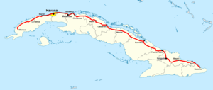
The Circuito Norte (CN), meaning "Northern Circuit", is a west-east highway spanning the length of the island of Cuba, through the Atlantic Coast. With a length of 1,222 km, it is the second-longest Cuban highway, after the "Carretera Central"; and two sections of it, named "Vía Blanca" and "Panamericana", are classified as Expressways.[1]
Route
Description
The CN starts in Mantua, in the west of Pinar del Río Province and, through the northern side of the island, crosses the provinces of Artemisa, Havana, Mayabeque, Matanzas, Villa Clara, Sancti Spíritus, Ciego de Ávila, Camagüey, Las Tunas and Holguín; until its end in Baracoa, Guantánamo Province, in which it shares the eastern endpoint of the Carretera Central. The motorway sections link Mariel to western Havana (the Panamericana), and eastern Havana to Cárdenas (Vía Blanca).
The road is mostly made up of roads in northern Cuba made before the Circuito Norte being connected together.
Table
The table below shows the route of the Circuito Norte.[1] Note: Provincial seats are shown in bold; the names shown under brackets in the section "Municipality" indicate the municipal seats; the symbol  indicates the motorway section.
| Settlement | Municipality | Province | Part of [2][3] |
|---|---|---|---|
| Mantua | Mantua | Pinar del Río | 1-1 |
| Vista Hermosa | |||
| Dimas (crossroad) | |||
| Baja | Minas de Matahambre | ||
| Río del Medio (crossroad) | |||
| Santa Lucía | |||
| La Sabana | |||
| Sitio Morales | |||
| San Cayetano (to Puerto Esperanza) | Viñales | ||
| Entronque La Palma (to Viñales) | |||
| Mina La Constancia | |||
| La Jagua | La Palma | ||
| Bella María | |||
| La Palma | |||
| La Ceya | |||
| Manuel Sanguily | |||
| Las Cadenas | |||
| La Mulata | |||
| Las Pozas | Bahía Honda | Artemisa | |
| Tres Palmas | |||
| El Volador | |||
| Harlem (crossroad) | |||
| Bahía Honda | |||
| San Diego de Nuñez (crossroad) | |||
| San Juan de Dios | |||
| Orozco | |||
| Silvio Caro | |||
| Cabañas | Mariel | ||
| Sandino | |||
| Dominica-Santa Isabel | |||
| Josefina | |||
| San Jacinto-Las Mangas | |||
| Quiebrahacha | |||
| Río Bongo | |||
| Nodarse | |||
| Mariel | |||
| La Boca | Carretera Panamericana | ||
| Mujica | |||
| Santa Barbara | |||
| Nuevo Mariel | |||
| Boca Guajaibón | |||
| Menelao Mora | Caimito | ||
| El Salado | |||
| Playa Baracoa | Bauta | ||
| Havana (Motorway sections limited to west and east suburbs) | The CN crosses the municipal boroughs of Playa, Plaza de la Revolución, Cerro, Habana Vieja, Diez de Octubre, Regla, San Miguel del Padrón, Guanabacoa, Habana del Este | Havana | Carretera Panamericana, Malecón, Quinta Avenida, 2-400, I-3 |
| Playa del Muerto | Santa Cruz del Norte | Mayabeque | I-3 |
| Boca de Jaruco | |||
| Santa Cruz del Norte | |||
| El Fraile | |||
| Playa Jibacoa | |||
| Concuní | |||
| Puerto Libre (to Arcos de Canasí) | |||
| Batey San Juan | |||
| Puerto Escondido | |||
| Bacunayagua | |||
| Rincón Moderno | Matanzas | Matanzas | |
| San Roque | |||
| San Valentín | |||
| Matanzas | |||
| Canímar | |||
| San Felipe | |||
| El Mamey | |||
| Carbonera | |||
| Boca de Camarioca | Cárdenas | ||
| Julián Alemán | |||
| Varadero | |||
| Santa Marta | |||
| Guásimas | |||
| Cárdenas | |||
| El Castillito | |||
| José Smith Comas | |||
| Mercedita | |||
| Máximo Gómez | Perico | ||
| Ategorrieta | Martí | ||
| Martí | |||
| Itabo | |||
| Zapato | |||
| Hoyo Colorado | |||
| Palma Sola | Corralillo | Villa Clara | |
| Corralillo | |||
| Sierra Morena | |||
| San Vicente | |||
| La Panchita (crorssroad) | |||
| Rancho Veloz | |||
| Quintín Banderas | |||
| José René Riquelme | Quemado de Güines | ||
| Quemado de Güines | |||
| Caguaguas | |||
| El Mogote (Mogotes de Jumagua) | Sagua la Grande | ||
| Jumagua (Mogotes de Jumagua) | |||
| Sagua la Grande | |||
| Sitiecito | |||
| Viana | |||
| Calabazar de Sagua | Encrucijada | ||
| Encrucijada | |||
| La Sierra | |||
| Pavón | Camajuaní | ||
| La Pedrera | |||
| Entronque Aguada de Moya | |||
| Aguada de Moya | |||
| Vueltas | |||
| Vega de Palma | |||
| Entronque de Vueltas (to Camajuaní) | 4–321 | ||
| Taguayabón | |||
| Palenque | |||
| Remedios | |||
| Marcelo Salado | Caibarién | ||
| Caibarién | |||
| Cambaíto | |||
| Dolores | |||
| Seibabo | Yaguajay | Sancti Spíritus | 4-123 |
| Yaguajay | |||
| Guayabera | |||
| Mayajigua | |||
| La Legua | |||
| Mabuya | Chambas | Ciego de Ávila | 5-123 |
| Piedra | |||
| Chambas | |||
| El Calvario | |||
| Falla | |||
| Ranchuelo | |||
| Las Cejas (to Peonia) | Ciro Redondo | ||
| Morón | Morón | ||
| Cunagua | Bolivia | ||
| La Veintiuno | |||
| Bolivia | |||
| Mamey (crossroad) | |||
| Miraflores Nuevo (to Pedro Ballester) | |||
| Tabor | Esmeralda | Camagüey | |
| Nuñez | |||
| Caonao | |||
| Esmeralda | |||
| Jiqui | |||
| Brasil[4] (crossroad) | |||
| Lombillo (crossroad) | |||
| Cubitas | Sierra de Cubitas | ||
| Sola | |||
| Lugareño (crossroad) | Minas | ||
| Nuevitas (crossroad) | Nuevitas | ||
| San Miguel de Bagá | |||
| Camalote (crossroad) | |||
| Manatí | Manatí | Las Tunas | |
| Dumañuecos (crossroad) | |||
| Marañón | Puerto Padre | ||
| Pozo Prieto (to Vázquez) | |||
| Puerto Padre | 6-123 | ||
| Aguada del Negro | |||
| Delicias | |||
| Jesús Menéndez | Jesús Menéndez | ||
| El Canal | |||
| Lora | |||
| La Yaya | |||
| Velasco | Gibara | Holguín | |
| Uñas | |||
| Aguas Claras | Holguín | 6-123, 6-221 | |
| Piedra Picada | |||
| Holguín | |||
| Los Haticos | Báguanos | 6-123 | |
| Manguito | |||
| Báguanos (crossroad) | |||
| La Esperanza | |||
| El Nispero (to San Germán) | |||
| Barajagua (to Marcané) | Cueto | ||
| Cueto | |||
| Santa Isabel de Nipe | Mayarí | ||
| Guaro | |||
| Juan Vicente | |||
| Mayarí | |||
| Cajimara | |||
| Santa Rita | |||
| Nicaro-Levisa | |||
| Cabonico | |||
| Téneme | Frank País | ||
| Playa Tanamo (to Barrederas) | |||
| Río Grande | |||
| Cayo Mambí (crossroad) | |||
| Sagua de Tánamo | Sagua de Tánamo | ||
| La Cuchilla | |||
| Los Indios | |||
| Centeno | Moa | ||
| Moa | |||
| Punta Gorda | |||
| Cañete | |||
| Yamanigüey | |||
| Jaragua | Baracoa | Guantánamo | |
| Santa María | |||
| Vega de Taco | |||
| Nibujón | |||
| Cayogüín | |||
| Paso de Toa | |||
| Mabujabo | |||
| Baracoa | Guantánamo | ||
See also
 Cuba portal
 Roads portal


References
External links
![]() Media related to Circuito Norte at Wikimedia Commons
Media related to Circuito Norte at Wikimedia Commons
- v
- t
- e
Main roads in Cuba
- A1
- A2
- A3
- A4
- Vía Blanca
- Mediodía
- Panamericana
- Isla de la Juventud
- Carretera Central (CC)
- Circuito Norte (CN)
- Circuito Sur (CS)
- Circuito Sur de Oriente (CSO)


