Creag Bheag


Creag Bheag
Highland, Scotland, United Kingdom
Creag Bheag[1] is a prominent hill in Scotland.
Etymology
The word Creag is a variation of crag (rock), while the gaelic term Bheag can be translated as small.[2]
Features

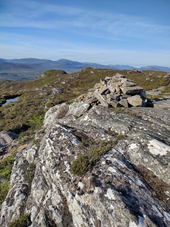
The hill overlooks from NW the centre of Kingussie; its E flanks are bordered by the Gynack Burn, a left-hand tributary of River Spey, and the N face dominates the Loch Gynack. The hilltop is marked by a cairn, as well as a nearby S summit almost at the same elevation of the main summit. Because of its topographic prominence the hill is classified as a Marilyn.[1]
History
Due to the easy access and the good panorama from its summit the Creag Behag has always been a popular walk. In 1828 some young men of Kingussie erected a memorial cairn, now disappeared, in order to mourn the loss of Alexander, the 4th Duke of Gordon. For the occasion a crowd of people reached the hilltop accompanied by a band of musicians playing their instruments.[3] {The source doesn't say that. The musicians played at another event that happened years later.Please check and correct.}
Access to the summit
The ascent to Creag Behag from Kingussie is considered a classic hillwalk, appreciated for the panoramic view from the hilltop on the surrounding area. The hike runs on well maintained and waymarked footpaths .[4]
Nature conservation
The hill, along with the surrounding area, is part of the Cairngorms National Park.
References
![]() Media related to Creag Bheag at Wikimedia Commons
Media related to Creag Bheag at Wikimedia Commons
 Scotland portal

- ^ a b c d "Creag Bheag". DoBIH (Database of British and Irish Hills). Retrieved 11 June 2022.
- ^ Turnbull, Ronald (2017). Walking in the Cairngorms - Over 100 Walks, Trails and Scrambles Including Lochnagar. Cicerone Press. ISBN 9781783625260. Retrieved 11 June 2022.
- ^ "Cairns in the landscape: Migrant stones and Migrant stories in Scotland". Landscapes Beyond Land - Routes, Aesthetics, Narratives. Berghahn Books. 2012. p. 127. ISBN 9780857456717. Retrieved 11 June 2022.
- ^ Hansen · 2022, Heather (June 2022). "57 Creag Behag". Walking Great Britain - England, Scotland, and Wales. Mountaineers Books. ISBN 9781680513189. Retrieved 11 June 2022.
{{cite book}}: CS1 maint: numeric names: authors list (link)
Panorama
-
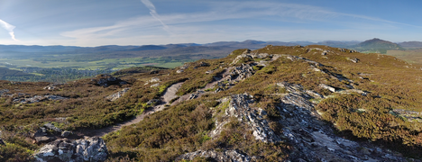 Southward panorama
 -
 Loch Gynack and Creag Mhor from Creag Bheag


