Den Hout
Village in North Brabant, Netherlands
51°39′28″N 4°48′42″E / 51.65778°N 4.81167°E / 51.65778; 4.81167[1]
[2]
(2021)[1]
4911[1]
Den Hout is a village in the Dutch province of North Brabant. It is located in the municipality of Oosterhout.[3][4]
The village was first mentioned in 1311 as "Rolinus dictus van den Houte", and means deciduous forest.[5] The area around Den Hout was settled during Roman times, but abandoned in 273.[4] Den Hout developed in the Middle Ages around a triangular village 'square'.[6]
The St Cornelius Church was built in 1877 and 1878 in Gothic Revival style and as an octagon spire.[6]
Den Hout was home to 650 people in 1840.[4]
Gallery
-
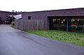 Pavillion Het Houtse Meer
 -
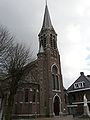 St Cornelius Church
 -
 Association building
 -
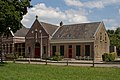
 School in Den Hout


References
- ^ a b c "Kerncijfers wijken en buurten 2021". Central Bureau of Statistics. Retrieved 18 April 2022.
- ^ "Postcodetool for 4911AA". Actueel Hoogtebestand Nederland (in Dutch). Het Waterschapshuis. Retrieved 18 April 2022.
- ^ "Den Hout". www.denhout.eu. Retrieved Jan 10, 2020.
- ^ a b c "Den Hout". Plaatsengids (in Dutch). Retrieved 18 April 2022.
- ^ "Den Hout - (geografische naam)". Etymologiebank (in Dutch). Retrieved 18 April 2022.
- ^ a b Chris Kolman & Ronald Stenvert (1997). Den Hout (in Dutch). Zwolle: Waanders. ISBN 90 400 9945 6. Retrieved 18 April 2022.
Wikimedia Commons has media related to Den Hout.
- v
- t
- e


