Derendorf
Locality of Düsseldorf, Germany
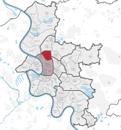
Derendorf is a quarter of Düsseldorf, Germany, part of the central Borough 1. It is located north of Pempelfort and Golzheim, west of Mörsenbroich and south of Unterrath.
Derendorf has an area of 3.36 km2 (1.30 sq mi),[1] and 20,584 inhabitants (2020).[2]
Derendorf was mentioned as a settlement first time in 1100. In 1384 Derendorf became a part of Düsseldorf. There has been a slaughterhouse in Derendorf since 1602. The main growth of Derendorf was in the time of Industrial Revolution.
Derendorf is traditionally an industrial area of Düsseldorf, inhabited mostly by a working-class population. The steelworks of Rheinmetall, the slaughterhouse and the brewery Schlösser are located here .
Many inhabitants of Derendorf are immigrants from Turkey, and the borough houses the central mosque of the Muslims in Düsseldorf.
See also
References
External links
Wikimedia Commons has media related to Derendorf.
- Administration, District Administration Archived 2020-05-26 at the Wayback Machine (in German)
- v
- t
- e
- Borough 1
- Borough 2
- Borough 3
- Borough 4
- Borough 5
- Borough 6
- Borough 7
- Borough 8
- Borough 9
- Borough 10

- Borough 1
- Altstadt
- Carlstadt
- Derendorf
- Golzheim
- Pempelfort
- Stadtmitte
- Borough 2
- Düsseltal
- Flingern-Nord
- Flingern-Süd
- Borough 3
- Bilk
- Flehe
- Friedrichstadt
- Hafen
- Hamm
- Oberbilk
- Unterbilk
- Volmerswerth
- Borough 4
- Heerdt
- Lörick
- Niederkassel
- Oberkassel
- Borough 5
- Angermund
- Kaiserswerth
- Kalkum
- Lohausen
- Stockum
- Wittlaer
- Borough 6
- Lichtenbroich
- Mörsenbroich
- Rath
- Unterrath
- Borough 7
- Gerresheim
- Grafenberg
- Hubbelrath
- Knittkuhl
- Ludenberg
- Borough 8
- Eller
- Lierenfeld
- Unterbach
- Vennhausen
- Borough 9
- Benrath
- Hassels
- Himmelgeist
- Holthausen
- Itter
- Reisholz
- Urdenbach
- Wersten
- Borough 10
- Garath
- Hellerhof
Authority control databases | |
|---|---|
| International |
|
| National |
|
51°14′38″N 6°47′33″E / 51.24389°N 6.79250°E / 51.24389; 6.79250
 | This Düsseldorf location article is a stub. You can help Wikipedia by expanding it. |
- v
- t
- e


