Euboea (regional unit)
Regional unit in Greece
Euboea Περιφερειακή ενότητα Εύβοιας | |
|---|---|
 Municipalities of Euboea | |
| 38°30′N 24°0′E / 38.500°N 24.000°E / 38.500; 24.000 | |
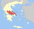
| Country | Greece |
| Administrative region | Central Greece |
| Seat | Chalcis |
| Area | |
| • Total | 4,167 km2 (1,609 sq mi) |
| Population (2021)[1] | |
| • Total | 210,778 |
| • Density | 51/km2 (130/sq mi) |
| Time zone | UTC+2 (EET) |
| • Summer (DST) | UTC+3 (EEST) |
| Postal code | 34x xx |
| Area code(s) | 222x0 |
| Vehicle registration | ΧΑ |
| Website | www |
Euboea (Greek: Περιφερειακή ενότητα Εύβοιας) is one of the regional units of Greece. It is part of the administrative region of Central Greece. It consists of the islands of Euboea and Skyros, as well as a 260 km2 area on the Greek mainland. Its land area is 4,167.449 km2, whereas the total land area of the municipalities actually on the island Euboea is 3,684.848 km2, which includes that of numerous small offshore islets (Petalies Islands) near Euboea's southern tip.
Administration
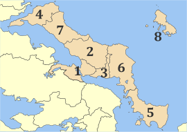
The Euboea regional unit is subdivided into 8 municipalities, numbered in the picture in the infobox. These are:[2]
- Chalcis (Chalkida, 1)
- Dirfys-Messapia (2)
- Eretria (3)
- Istiaia-Aidipsos (4)
- Karystos (5)
- Kymi-Aliveri (6)
- Mantoudi-Limni-Agia Anna (7)
- Skyros (8)
Prefecture
As a part of the 2011 Kallikratis government reform, the former Euboea Prefecture (Greek: Νομός Εύβοιας) was transformed into a regional unit within the Central Greece region, without any change in boundaries. At the same time, the municipalities were reorganised, according to the table below.[2]
| New municipality | Old municipalities | Seat |
|---|---|---|
| Chalcis (Chalkida) | Chalcis | Chalcis |
| Lilantia | ||
| Nea Artaki | ||
| Anthidona | ||
| Avlida | ||
| Dirfys-Messapia | Dirfys | Psachna |
| Messapia | ||
| Eretria | Eretria | Eretria |
| Amarynthos | ||
| Istiaia-Aidipsos | Aidipsos | Istiaia |
| Artemisio | ||
| Istiaia | ||
| Lichada | ||
| Oreoi | ||
| Karystos | Karystos | Karystos |
| Kafireas | ||
| Marmari | ||
| Styra | ||
| Kymi-Aliveri | Kymi | Aliveri |
| Avlon | ||
| Dystos | ||
| Konistres | ||
| Tamyneoi | ||
| Mantoudi-Limni-Agia Anna | Elymnioi | Mantoudi |
| Kireas | ||
| Nileas | ||
| Skyros | Skyros | Skyros |
Note: the former municipalities of Anthidona and Avlida are on the mainland, attached to the northeastern part of Boeotia. Skyros is an island by itself.
Provinces
Note: Provinces no longer hold any legal status in Greece.
Population
| Year | Pop. | ±% |
|---|---|---|
| 1991[3] | 202,131 | — |
| 2001[3] | 207,305 | +2.6% |
| 2011[3] | 210,815 | +1.7% |
| 2021[1] | 210,778 | −0.0% |
References
- ^ a b "Αποτελέσματα Απογραφής Πληθυσμού - Κατοικιών 2021, Μόνιμος Πληθυσμός κατά οικισμό" [Results of the 2021 Population - Housing Census, Permanent population by settlement] (in Greek). Hellenic Statistical Authority. 29 March 2024.
- ^ a b "ΦΕΚ A 87/2010, Kallikratis reform law text" (in Greek). Government Gazette.
- ^ a b c "Απογραφές πληθυσμού 1991,2001,2011 σύμφωνα με την κωδικοποίηση της Απογραφής 2011" (in Greek). Hellenic Statistical Authority. Retrieved 17 April 2024.
- v
- t
- e
Administrative division of the Central Greece Region
- Area
- 15,549 km2 (6,004 sq mi)
- Population
- 547,390 (as of 2011)
- Municipalities
- 25 (since 2011)
- Capital
- Lamia
- Agrafa
- Karpenisi
- Delphi
- Dorida
- Amfikleia-Elateia
- Domokos
- Kamena Vourla
- Lamia
- Lokroi
- Makrakomi
- Stylida
- Regional governor
- Fanis Spanos (since 2019)
- Decentralized Administration
- Thessaly and Central Greece
| Authority control databases: Geographic |
|
|---|


