Fox, Virginia
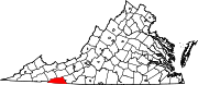
Unincorporated community in Grayson County, Virginia, United States
Unincorporated community in Virginia, United States
36°36′33″N 081°17′36″W / 36.60917°N 81.29333°W / 36.60917; -81.2933324348
Fox is an unincorporated community in Grayson County, Virginia, United States located at the intersection of U.S. Route 58 (Wilson Highway) and State Route 711 (Fox Creek Road and Maple Road).[1]
Fox has a cemetery, the Fox Union Cemetery, located on Fox Creek Road.[2]
Geography
Fox sits at an elevation of 2,592 feet (790 m) in rolling hills within the Appalachian Mountains near the Virginia-North Carolina border.[1] It is north of the New River and west of Fox Creek.[3]
References
- ^ a b c "Fox". Geographic Names Information System. United States Geological Survey, United States Department of the Interior.
- ^ "Fox Union Cemetery". Geographic Names Information System. United States Geological Survey, United States Department of the Interior.
- ^ "Fox Creek". Geographic Names Information System. United States Geological Survey, United States Department of the Interior.
- v
- t
- e
Municipalities and communities of Grayson County, Virginia, United States
County seat: Independence
communities
‡This populated place also has portions in an adjacent county or counties
- Virginia portal
- United States portal


