Gargoyle Mountain
Mountain in Alberta, Canada


Gargoyle Mountain
Location of Gargoyle Mountain in Alberta
Show map of Alberta
Gargoyle Mountain
Gargoyle Mountain (Canada)
Show map of CanadaGargoyle Mountain is a 2,693-metre (8,835-foot) mountain summit located in Jasper National Park, in the Canadian Rockies of Alberta, Canada. The peak is situated 23 kilometres north of the municipality of Jasper, and is a prominent landmark in the Athabasca Valley visible from Highway 16 and The Canadian. Its nearest higher peak is Cliff Mountain, 5.5 km (3.4 mi) to the west.[1] Gargoyle Mountain was named in 1916 by Morrison P. Bridgland for the fact a stream heads at the mountain, like a gargoyle or spout.[3] Bridgland (1878-1948) was a Dominion Land Surveyor who named many peaks in Jasper Park and the Canadian Rockies.[4] The mountain's name was officially adopted in 1956 by the Geographical Names Board of Canada.[2]
Climate
Based on the Köppen climate classification, Gargoyle Mountain is located in a subarctic climate with cold, snowy winters, and mild summers.[5] Temperatures can drop below -20 °C with wind chill factors below -30 °C. In terms of favorable weather, June through September are the best months to climb. Precipitation runoff from Gargoyle Mountain flows into the Athabasca River.
See also
Gallery
-
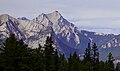
 Esplanade Mountain (left) and Gargoyle Mountain (center)
 -
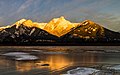
 Winter scene of Gargoyle Mountain
 -
 Gargoyle Mountain from Highway 16
 -
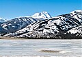
 Gargoyle Mountain to right
 -
 Southeast aspect
 -
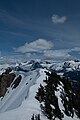 Snowy slopes of Gargoyle Mountain


References
- ^ a b c d "Gargoyle Mountain". Bivouac.com. Retrieved 2019-02-25.
- ^ a b c "Gargoyle Mountain". Geographical Names Data Base. Natural Resources Canada. Retrieved 2019-02-25.
- ^ Place-names of Alberta. Ottawa: Geographic Board of Canada. 1928. p. 56.
- ^ MacLaren, I.S. (2005). Mapper of Mountains M.P. Bridgland in the Canadian Rockies 1902-1930. With Eric Higgs, Gabrielle Zezulka-Mailloux. Edmonton, AB: The University of Alberta Press. ISBN 0-88864-456-6.
- ^ Peel, M. C.; Finlayson, B. L.; McMahon, T. A. (2007). "Updated world map of the Köppen−Geiger climate classification". Hydrol. Earth Syst. Sci. 11: 1633–1644. ISSN 1027-5606.
External links
 Media related to Gargoyle Mountain at Wikimedia Commons
- Parks Canada web site: Jasper National Park
- v
- t
- e
- Ball
- Bare
- Beaverfoot
- Blue
- Bow
- Crowsnest
- Elk
- Fairholme
- Fiddle
- Flathead
- Foothills
- High Rock
- Kananaskis
- Livingstone
- Lizard
- Maligne
- Massive
- Misty
- Morrissey
- Palliser
- President
- Queen Elizabeth
- Rainbow
- Ram
- Sawback
- Sentinel
- Slate
- South Jasper
- Sundance
- Terminal
- Tower of London
- Vermilion
- Victoria Cross
- Waputik
- Winston Churchill
- Continental Ranges
- Hart Ranges
- Muskwa Ranges
- Alberta
- Andromeda
- Assiniboine
- Athabasca
- Brazeau
- Bryce
- Cascade
- Castle
- Castleguard
- Clemenceau
- Columbia
- Cory
- Edith Cavell
- Forbes
- Hector
- Hosmer
- Hungabee
- Joffre
- Kitchener
- Lyell
- Heart
- Pilot
- Pyramid
- Resplendent
- Robson
- Rundle
- Sarbach
- Saskatchewan
- Smythe
- Snow Dome
- Stanley Peak
- Sulphur
- Temple
- Three Sisters
- Trinity
- Twin
- Ulysses
- Unnamed Alberta–BC mountain (formerly Mount Pétain)
- Whymper
see List of rivers of the Canadian Rockies and Category:Rivers of the Canadian Rockies
- Mountain Stoney
- Mountain Metis
| International | |
|---|---|
| National |
|
| Provincial (AB) |
|
| Provincial (BC) |
- See also
- Geography portal
- Canada portal


