Ghana's material cultural heritage
Museums and monuments in Ghana
The monuments list is taken from the Ghana Museums and Monuments Board, according to their description "legal custodian of Ghana's material cultural heritage (movable and immovable heritage)"[1] GMMB classifies the monuments:
The ID used on this page in reference to the Regions of Ghana are based on the ISO Regional ID standards.
A. Western Region
| ID | Description | Region | Original function | Built | Location | Address | Comment | Coordinates | Image |
|---|---|---|---|---|---|---|---|---|---|
| GH-WP-001 | Fort Apollonia | Western | Fort | 1765 and 1771 | Beyin | 4°45′00″N 2°01′00″W / 4.75°N 2.016667°W / 4.75; -2.016667 (Fort Apollonia GH-WP-001) |   Upload Photo | ||
| GH-WP-002 | Fort Saint Anthony | Western | Fort | 1515; expanded in 1642 and 1872 by Dutch | Axim | 4°52′02″N 2°14′23″W / 4.8671749°N 2.239667°W / 4.8671749; -2.239667 (Fort Saint Anthony GH-WP-002) | 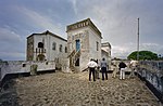 Upload Photo | ||
| GH-WP-003 | Fort Groß Friedrichsburg | Western | Fort | 1683 | Princestown | article only in german | 4°47′28″N 2°08′02″W / 4.791111°N 2.133889°W / 4.791111; -2.133889 (Fort Groß Friedrichsburg GH-WP-003) |  Upload Photo | |
| GH-WP-004 | Fort Dorothea | Western | Fort | 1684–1687; 1698–1711; April 1712–1717 | Akwida | 4°45′00″N 2°01′00″W / 4.75°N 2.016667°W / 4.75; -2.016667 (Fort Dorothea GH-WP-004) |  Upload Photo Upload Photo | ||
| GH-AA-005 | Museum of Nzema Culture & History | Western | Museum | Fort Apollonia | Upload Photo Upload Photo | ||||
| GH-WP-005 | Fort Metal Cross | Western | Fort | 1683 | Dixcove | 4°47′27″N 1°57′01″W / 4.790936°N 1.950362°W / 4.790936; -1.950362 (Fort Metal Cross GH-WP-005) | 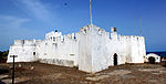 Upload Photo | ||
| GH-WP-006 | Fort Batenstein | Western | Fort | Between 1595 and 1600 | Butre | 4°49′18″N 1°55′16″W / 4.8216314°N 1.9211483°W / 4.8216314; -1.9211483 (Fort Batenstein GH-WP-006) |  Upload Photo | ||
| GH-WP-007 | Fort Orange | Western | Fort | 1690 | Sekondi | 4°56′09″N 1°42′26″W / 4.9357°N 1.7073°W / 4.9357; -1.7073 (Fort Orange GH-WP-007) |  Upload Photo | ||
| GH-WP-008 | Fort St. Sebastian | Western | Fort | 1590 | Shama | 5°01′45″N 1°37′16″W / 5.029111°N 1.621061°W / 5.029111; -1.621061 (Fort St. Sebastian GH-WP-008) |  Upload Photo | ||
| GH-WP-00P | Nzulezu Stilt Settlement | Western | Settlement | Lake Tadane | Upload Photo Upload Photo |
B. Central Region
| ID | Description | Region | Original function | Built | Location | Address | Comment | Coordinates | Image |
|---|---|---|---|---|---|---|---|---|---|
| GH-CP-001 | Fort Komenda | Central | Fort | 1957 | British Komenda |  Upload Photo | |||
| GH-CP-002 | Fort Vredenburg | Central | Fort | Dutch Komenda |  Upload Photo | ||||
| GH-CP-003 | Castle of St. George's | Central | Castle | 1482 | Elmina | Also known as Elmina Castle[2] | 5°05′00″N 1°21′00″W / 5.083333°N 1.35°W / 5.083333; -1.35 (Castle of St. George's GH-CP-003) | 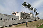 Upload Photo | |
| GH-AA-003 | Cape Coast Castle Museum | Central Region | Museum | Cape Coast | Museum is located within the castle. Photography not allowed there | 5°06′12″N 1°14′33″W / 5.103333°N 1.2425°W / 5.103333; -1.2425 (Cape Coast Castle Museum GH-AA-003) | 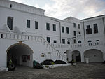 Upload Photo | ||
| GH-AA-004 | Elmina Castle Museum | Central Region | Museum | Elmina | 5°05′00″N 1°21′00″W / 5.083333°N 1.35°W / 5.083333; -1.35 (Elmina Castle Museum GH-AA-004) | 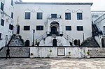 Upload Photo | |||
| GH-CP-004 | Fort St. Jago | Central | Fort | 1555 and 1558 | Elmina | 5°05′00″N 1°21′00″W / 5.083333°N 1.35°W / 5.083333; -1.35 (Fort St. Jago GH-CP-004) | 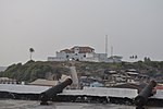 Upload Photo | ||
| GH-CP-005 | Fort Goede Hoop a.k.a. Fort Good Hope | Central | Fort | 1705 | Senya Beraku | 5°23′15″N 0°29′23″W / 5.3874°N 0.4898°W / 5.3874; -0.4898 (Fort Goede Hoop GH-CP-005) |  Upload Photo | ||
| CE-GH-CP-006 | Fort Lijdzaamheid a.k.a. Patience, Leydsaemheyt | Central | Fort | 1697 | Apam | 5°17′36″N 0°44′32″W / 5.29336°N 0.74226°W / 5.29336; -0.74226 (Fort Lijdzaamheid CE-GH-CP-006) | 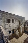 Upload Photo | ||
| GH-CP-007 | Fort Amsterdam (Ghana) | Central | Fort | 1631, fort rebuilt by the English in 1645 | Abandzi | 5°12′09″N 1°05′25″W / 5.2025°N 1.090278°W / 5.2025; -1.090278 (Fort Amsterdam (Ghana) GH-CP-007) |  Upload Photo | ||
| GH-CP-008 | The Little Fort | Central | Fort | Anomabu | 5°11′12″N 1°06′32″W / 5.1865638°N 1.1089244°W / 5.1865638; -1.1089244 (The Little Fort GH-CP-008) |  Upload Photo | |||
| GH-CP-009 | Fort William (Ghana) a.k.a. Anomabu Castle | Central | Fort | 1640 | Anomabu | 5°10′00″N 1°07′00″W / 5.1667°N 1.1167°W / 5.1667; -1.1167 (Fort William (Ghana) GH-CP-009) |  Upload Photo | ||
| GH-CP-010 | Fort Nassau | Central | Fort | 1612 | Moree | 5°08′00″N 1°12′00″W / 5.133333°N 1.2°W / 5.133333; -1.2 (Fort Nassau GH-CP-010) |  Upload Photo | ||
| GH-CP-011 | Fort Fredericksburg | Central | Fort | Amanful | 4°52′00″N 1°47′00″W / 4.8666667°N 1.7833333°W / 4.8666667; -1.7833333 (Fort Fredericksburg GH-CP-011) | 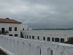 Upload Photo | |||
| GH-CP-012 | Cape Coast Castle | Central | Castle | 1653 | Cape Coast | 5°06′18″N 1°14′50″W / 5.105056°N 1.247234°W / 5.105056; -1.247234 (Cape Coast Castle GH-CP-012) | 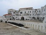 Upload Photo | ||
| GH-CP-013 | Fort McCarthy | Central | Castle | 1822 | Cape Coast | 5°06′N 1°15′W / 5.1°N 1.25°W / 5.1; -1.25 (Fort McCarthy GH-CP-013) | 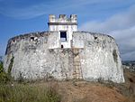 Upload Photo | ||
| GH-CP-014 | Fort Victoria | Central | Fort | 1712 | Cape Coast |  Upload Photo | |||
| GH-CP-015 | Fort William (Lighthouse) | Central | Fort | 1753 | Cape Coast | 5°06′N 1°15′W / 5.1°N 1.25°W / 5.1; -1.25 (Fort William (Lighthouse) GH-CP-015) | 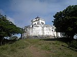 Upload Photo | ||
| GH-CP-016 | Fort Royal | Central | Fort | Cape Coast | 5°06′N 1°15′W / 5.1°N 1.25°W / 5.1; -1.25 (Fort Royal GH-CP-016) | Upload Photo Upload Photo | |||
| GH-CP-017 | Statue of George Ekem Ferguson | Central | Statue | Anomabo, Near Fort Williams | Upload Photo Upload Photo |
C. Greater Accra Region
| ID | Description | Region | Original function | Built | Location | Address | Comment | Coordinates | Image |
|---|---|---|---|---|---|---|---|---|---|
| GH-AA-001 | National Museum | Greater Accra | Museum | 1957 | Barnes Road, Accra | 5°33′24″N 0°12′28″W / 5.556667°N 0.207778°W / 5.556667; -0.207778 (National Museum GH-AA-001) |  Upload Photo | ||
| GH-AA-002 | Museum of Science & Technology | Greater Accra | Museum | 1963 | Barnes Road, Accra. | Ghana Museum of Science and Technology |  Upload Photo | ||
| GH-AA-003 | Ussher Fort | Greater Accra | Fort | 1649 | Ussher Town, Accra |  Upload Photo
| |||
| GH-AA-004 | James Fort | Greater Accra | Fort | 1673 | John Evans Atta Mills High Street, Accra | James Fort Ghana |  Upload Photo | ||
| GH-AA-05 | Christiansborg Castle a.k.a. Osu Castle | Greater Accra | Fort | 1659 | Osu, Accra |  Upload Photo | |||
| GH-AA-06 | Fort Augustaborg | Greater Accra | Fort | 1787 | Teshie |  Upload Photo | |||
| GH-AA-07 | Museum of Archaeology | Greater Accra | Museum | University of Ghana, Department of Archeology, Accra |  Upload Photo | ||||
| GH-EP-08 | Fort Vernon | Greater Accra | Fort | 1742 | Prampram | 5°43′29″N 0°07′00″E / 5.7247051°N 0.1167463°E / 5.7247051; 0.1167463 (Fort Vernon GH-EP-08) |  Upload Photo | ||
| GH-EP-09 | Holy Trinity Church Accra | Greater Accra | Church | 1894 | Accra High street | 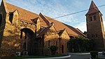 Upload Photo | |||
| GH-EP-10 | Grave ruins of Seagent Adjetey | Accra | Grave | La | Located at the La cluster of school field | Upload Photo Upload Photo |
E. Volta Region
| ID | Description | Region | Original function | Built | Location | Address | Comment | Coordinates | Image |
|---|---|---|---|---|---|---|---|---|---|
| GH-TV-001 | Fort Prinzenstein | Volta | Fort | 1734 | Keta | 5°54′39″N 0°59′31″E / 5.910833°N 0.991944°E / 5.910833; 0.991944 (Fort Prinzenstein GH-TV-001) |  Upload Photo | ||
| GH-TV-002 | Volta Regional Museum | Volta | Museum | 1973 | Ho | 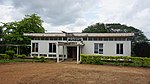 Upload Photo |
F. Ashanti Region
| ID | Description | Region | Original function | Built | Location | Address | Comment | Coordinates | Image |
|---|---|---|---|---|---|---|---|---|---|
| GH-AH-001 | Fort Kumasi | Ashanti | Fort | 1820 | Kumasi |  Upload Photo | |||
| GH-AH-002 | Kumasi Military Museum | Ashanti | Museum | Kumasi | 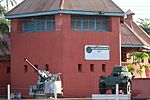 Upload Photo | ||||
| GH-AH-003 | Yaw Tano Shrine a.k.a. Tano Yaw Shrine | Ashanti | Shrine | Ejisu-Besease | at Besease, about 20.8 km on the Kumasi-Accra road. | 5°33′26″N 1°11′45″W / 5.5572433°N 1.1959147°W / 5.5572433; -1.1959147 (Yaw Tano Shrine GH-AH-003) | 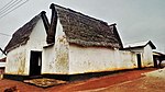 Upload Photo | ||
| GH-AH-004 | Akwasi Sima Shrine a.k.a. Kwasi Kuma Shrine | Ashanti | Shrine | Adarkwa Jachie | about 16 km on the Kumasi-Ejisu road. | 6°43′25″N 1°30′41″W / 6.7237°N 1.5114°W / 6.7237; -1.5114 (Akwasi Sima Shrine GH-AH-004) | Upload Photo Upload Photo | ||
| GH-AH-005 | Tano Abenamu Subunu Shrine | Ashanti | Shrine | Abirem (Alternative Spelling: Abirim) | Abirem is about 12.8 km from Kumasi on the Antoa Road, Coord of Antoa Road | 6°42′30″N 1°36′20″W / 6.7082007°N 1.605463°W / 6.7082007; -1.605463 (Tano Abenamu Subunu Shrine GH-AH-005) | 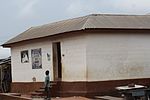 Upload Photo | ||
| GH-AH-006 | Tano Kwadwo Shrine | Ashanti | Shrine | Saaman | Saaman is about 12.6 km north-east of Kumasi, on the former Odumakoma Tempong road that led toNorthern Ghana. | 6°46′15″N 1°32′33″W / 6.7709°N 1.5424°W / 6.7709; -1.5424 (Tano Kwadwo Shrine GH-AH-006) |  Upload Photo | ||
| GH-AH-007 | Atuo Kosua Shrine | Ashanti | Shrine | Adwinase (Alternative Spelling: Edwenase) | Off the Ejisu-Onwi road. | 6°41′19″N 1°26′05″W / 6.6886°N 1.4348°W / 6.6886; -1.4348 (Atuo Kosua Shrine GH-AH-007) | 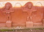 Upload Photo | ||
| GH-AH-008 | Kentinkrono Shrine | Ashanti | Shrine | Kentinkrono | At Kentinkrono, about 20.8km on the Kumasi-Ejisu road. | 6°41′36″N 1°33′10″W / 6.6934°N 1.5529°W / 6.6934; -1.5529 (Kentinkrono Shrine GH-AH-008) |  Upload Photo | ||
| GH-AH-009 | Tano Odomankoma Shrine | Ashanti | Shrine | Bogwiase (Alternative Spelling: Bodwease) | foot of the rocky Mampong scarp, about 10 km from Effiduase, in the Sekyere West District. | 6°55′04″N 1°20′16″W / 6.9178°N 1.3377°W / 6.9178; -1.3377 (Tano Odomankoma Shrine GH-AH-009) | Upload Photo Upload Photo | ||
| GH-AH-010 | Asawase Shrine a.k.a. Tano Banie Shrine | Ashanti | Shrine | Asawase near Ejisu | to the south of Ejisu, about 10 km on the second-class road linking Ejisu and Apromase. | 6°41′10″N 1°29′19″W / 6.6860°N 1.4885°W / 6.6860; -1.4885 (Asawase Shrine GH-AH-010) | Upload Photo Upload Photo | ||
| GH-AH-011 | Asenemaso Shrine | Ashanti | Shrine | Asenemaso | Kumasi-Sunyani road, at a distance of about 15 km from Kejetia. | 6°42′16″N 1°43′13″W / 6.704578°N 1.720150°W / 6.704578; -1.720150 (Asenemaso Shrine GH-AH-011) | Upload Photo Upload Photo |
G. Northern Region
| ID | Description | Region | Original function | Built | Location | Address | Comment | Coordinates | Image |
|---|---|---|---|---|---|---|---|---|---|
| GH-NP-001 | Larabanga Mosque | Northern Region | Mosque | 14th Century | Laribanga |  Upload Photo
| |||
| GH-NP-002 | Bole Mosque | Northern Region | Mosque | Bole Mosque is in West Gonja District, in the Northern Region. | Upload Photo Upload Photo
| ||||
| GH-NP-003 | Babatu's grave | Northern Region | Old Grave | Yendi | Babatu was a notorious slave raider from Niger. There are remains of his grave and some equipment he and his army used in capturing slaves on Grunsi land. |  Upload Photo
| |||
| GH-NP-004 | The German cemetery | Northern Region | Cemetery | Yendi | German cemetery popularly called "German grave” contains graves of German and Dutch soldiers who died in their colonization efforts in a war with Dagombas. |  Upload Photo
| |||
| GH-NP-005 | Naa Dataa Tua | Northern Region | Cemetery | Yendi | Na Dataa Tua is a site is a place where men who had affairs with the Ya-Na's wives were beheaded. At the site are a sacrificial stone and a baobab tree, at the base of which the victims were beheaded. | Upload Photo Upload Photo
| |||
| GH-NP-006 | Tamale Central Mosque | Northern Region | Mosque | Tamale | The oldest mosque in the Capital of the northern region. . | Upload Photo Upload Photo
| |||
| GH-NP-007 | Dakpema tomb | Northern Region | Cemetery | Tamale | The ancient cave where mortal remains of Dakpemas (kings of Tamale kingdom) are kept. . | Upload Photo Upload Photo
| |||
| GH-NP-008 | Laribanga Mystery Stone | Northern Region | Mystic stone | Tamale | Larabanga Mystery Stone During the British times, in Ghana there was a road that was laid near the Larabanga Mosque, a stone was removed during the process to make way for the road. The next day, the stone was found again on the same place it was displaced from. . | Upload Photo Upload Photo |
H. Upper East
| ID | Description | Region | Original function | Built | Location | Address | Comment | Coordinates | Image |
|---|---|---|---|---|---|---|---|---|---|
| GH-UE-001 | Upper East Regional Museum | Upper East | Museum | Bolgatanga | 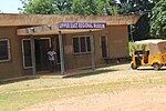 Upload Photo
| ||||
| GH-UE-002 | Old Navrongo Catholic Cathedral Building | Upper East | Church | 1920 | Navrongo |  Upload Photo
| |||
| GH-UE-003 | Pikworo Slave camp | Upper East | Slave camp | 1704 | Paga |  Upload Photo |
hI. Upper West
| ID | Description | Region | Original function | Built | Location | Address | Comment | Coordinates | Image |
|---|---|---|---|---|---|---|---|---|---|
| GH-UW-001 | Gwollu Defence Wall | Upper West | Monument | Gwollu | Gwollu is 70 km north of Wa, in the Upper West Region of Ghana | Upload Photo Upload Photo
| |||
| GH-UW-003 | Wa Naa's Palace | Upper West | Palace | Wa | 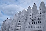 Upload Photo
| ||||
| GH-UW-003 | Wechiau Mosque | Upper West | Mosque | Wechiau | Upload Photo Upload Photo
| ||||
| GH-UW-004 | Dondoli Mosque | Upper West | Mosque | Wa | This 19th Century mosque is in Wa, the capital of the Upper West Region. | Upload Photo Upload Photo |
Archeological Sites
The Museum of Archeology, University of Ghana is listed on the QMMB site.[3]
References
- v
- t
- e
| Historical timeline | |
|---|---|
| By topic |
|
| Culture |
|
|---|---|
- Category


