Gortnaleck Court Tomb
Court cairn in County Sligo, Ireland
54°23′04″N 8°29′03″W / 54.384563°N 8.484219°W / 54.384563; -8.484219 National monument of Ireland
Gortnaleck Court Tomb is a court cairn and National Monument located in County Sligo, Ireland.[1]
Location
Gortnaleck Court Tomb is located in a small field on a deserted farm 2.1 km (1.3 mi) north of Benbulben and 2.7 km (1.7 mi) east-southeast of Grange.[2] Benbulben dominates the view to the east while there is a wide view out across the Atlantic Ocean to the west. The monument is on private property.
History
Gortnaleck Court Tomb was constructed in the Neolithic, c. 4000–2500 BC.[3] The monument was surveyed by Sean O Nuallain for the Megalithic Survey of County Sligo which was published in 1976.
Description
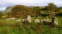
The monument consists of a central court which is 6 m (20 ft) in diameter. An entrance passage to the south leads into the court. A pair of galleries open to the east and west. The west gallery is 7 m (23 ft) long and the east is 5 m (16 ft) by 2.5 m (8 ft 2 in) long.[4] The majority of the cairn stones are missing, haven been used to construct the massive drystone field walls around the monument.
References
- ^ "Proceedings of the Royal Irish Academy: Archaeology, linguistics and literature". Hodges, Figgis. 1956 – via Google Books.
- ^ "The Journal of the Royal Society of Antiquaries of Ireland". The Society. 1975 – via Google Books.
- ^ Byrne, Martin. "The Sacred Island – Benbulben – Dartry Mountain – Benwisken – Tievebawn – Kingsmountain – Truskmore".
- ^ "Gortnaleck Court Tomb". Megalithic Monuments of Ireland. July 2010.


