Grade II* listed buildings in High Peak
Map all coordinates using OpenStreetMap
Download coordinates as:
- KML
- GPX (all coordinates)
- GPX (primary coordinates)
- GPX (secondary coordinates)
There are over 20,000 Grade II* listed buildings in England. This page is a list of these buildings in the district of High Peak in Derbyshire.
List of buildings
| Name | Location | Type | Completed [note 1] | Date designated | Grid ref.[note 2] Geo-coordinates | Entry number [note 3] | Image |
|---|---|---|---|---|---|---|---|
| Church of St John the Baptist | Bamford | Church | 1856–60 | 21 April 1967 | SK2076083376 53°20′49″N 1°41′23″W / 53.346874°N 1.689625°W / 53.346874; -1.689625 (Church of St John the Baptist) | 1087859 |  More images |
| Church of St Edmund | Castleton | Church | Early 12th century | 21 April 1967 | SK1502882901 53°20′34″N 1°46′33″W / 53.342797°N 1.775748°W / 53.342797; -1.775748 (Church of St Edmund) | 1087866 | 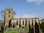 More images |
| Church of St Thomas of Canterbury | Chapel-en-le-Frith | Church | Early 14th century | 21 April 1967 | SK0577080827 53°19′28″N 1°54′53″W / 53.324334°N 1.914836°W / 53.324334; -1.914836 (Church of St Thomas of Canterbury) | 1088062 |  More images |
| Stodhart Tunnel | Chapel-en-le-Frith | Tunnel | 1796 | 3 September 1985 | SK0588081490 53°19′49″N 1°54′47″W / 53.330293°N 1.913173°W / 53.330293; -1.913173 (Stodhart Tunnel) | 1334843 | 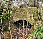 More images |
| Chinley Independent Chapel | Chinley | Congregational chapel | 1711 | 21 April 1967 | SK0552582001 53°20′06″N 1°55′07″W / 53.334889°N 1.918494°W / 53.334889; -1.918494 (Chinley Independent Chapel) | 1088033 | 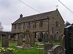 More images |
| Stable block at Park Hall | Little Hayfield | House | Early 19th century | 21 April 1967 | SK0380888332 53°23′31″N 1°56′39″W / 53.391811°N 1.944204°W / 53.391811; -1.944204 (Stable block at Park Hall) | 1298715 | 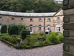 |
| Torr Vale Mill, attached weir sluice gates, watercourse walls, headrace arches, retaining walls and steps | New Mills | Mill | circa 1790 | 23 February 1998 | SJ9990385332 53°21′53″N 2°00′11″W / 53.364858°N 2.002921°W / 53.364858; -2.002921 (Torr Vale Mill, attached weir sluice gates, watercourse walls, headrace arches, retaining walls and steps) | 1119721 |  More images |
| Canal Warehouse at end of Peak Forest Canal | Whaley Bridge | Canal warehouse | 1832 | 18 December 1972 | SK0118681620 53°19′53″N 1°59′01″W / 53.331491°N 1.983654°W / 53.331491; -1.983654 (Canal Warehouse at end of Peak Forest Canal) | 1088081 |  |
| St James' Church | Taxal, Whaley Bridge | Church | 16th or 17th century | 19 September 1977 | SK0065379810 53°18′55″N 1°59′30″W / 53.315223°N 1.99166°W / 53.315223; -1.99166 (St James' Church) | 1088087 |  More images |
| Church of St Margaret | Wormhill | Church | 1864 | 21 April 1967 | SK1245574182 53°15′52″N 1°48′53″W / 53.264491°N 1.814732°W / 53.264491; -1.814732 (Church of St Margaret) | 1087930 |  More images |
| Wormhill Hall | Wormhill | Country house | 1697 | 25 October 1951 | SK1246074068 53°15′48″N 1°48′53″W / 53.263466°N 1.814661°W / 53.263466; -1.814661 (Wormhill Hall) | 1146377 | 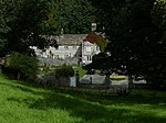 More images |
| 12 stone urns and linking walls and steps | Buxton | Urns | 1818 | 4 December 1990 | SK0584773537 53°15′32″N 1°54′50″W / 53.258806°N 1.913812°W / 53.258806; -1.913812 (12 stone urns and linking walls and steps) | 1257871 | 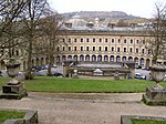 More images |
| Church of St Anne | Buxton | Church | Earlier than 1625 | 25 January 1951 | SK0572272975 53°15′14″N 1°54′57″W / 53.253755°N 1.915695°W / 53.253755; -1.915695 (Church of St Anne) | 1259392 |  More images |
| Church of St John the Baptist | Buxton | Church | 1802–11 | 25 January 1951 | SK0561773550 53°15′32″N 1°55′02″W / 53.258925°N 1.917259°W / 53.258925; -1.917259 (Church of St John the Baptist) | 1258025 | 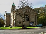 More images |
| Devonshire Royal Hospital | Buxton | Stable | 1785–90 | 21 December 1970 | SK0565173672 53°15′36″N 1°55′00″W / 53.260021°N 1.916747°W / 53.260021; -1.916747 (Devonshire Royal Hospital) | 1259351 |  More images |
| Old Hall Hotel | Buxton | Town house | 1572 | 25 January 1951 | SK0575473477 53°15′30″N 1°54′55″W / 53.258267°N 1.915207°W / 53.258267; -1.915207 (Old Hall Hotel) | 1257847 |  More images |
| Buxton Opera House | Buxton | Opera house | 1901–03 | 21 December 1970 | SK0562573485 53°15′30″N 1°55′02″W / 53.258341°N 1.91714°W / 53.258341; -1.91714 (Buxton Opera House) | 1257789 | 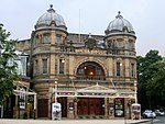 More images |
| 1–6 The Square | Buxton | Apartments | 1803–06 | 25 January 1951 | SK0571973512 53°15′31″N 1°54′57″W / 53.258582°N 1.915731°W / 53.258582; -1.915731 (1–6 The Square) | 1257843 | 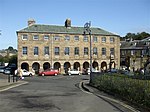 More images |
See also
- Grade I listed buildings in Derbyshire
- Grade II* listed buildings in Amber Valley
- Grade II* listed buildings in Bolsover (district)
- Grade II* listed buildings in Chesterfield
- Grade II* listed buildings in Derby
- Grade II* listed buildings in Derbyshire Dales
- Grade II* listed buildings in Erewash
- Grade II* listed buildings in North East Derbyshire
- Grade II* listed buildings in South Derbyshire
- Listed buildings in New Mills
Notes
- ^ The date given is the date used by Historic England as significant for the initial building or that of an important part in the structure's description.
- ^ Sometimes known as OSGB36, the grid reference is based on the British national grid reference system used by the Ordnance Survey.
- ^ The "List Entry Number" is a unique number assigned to each listed building and scheduled monument by Historic England.
External links
- v
- t
- e
- Bedfordshire
- Berkshire
- Bristol
- Buckinghamshire
- Cambridgeshire
- Cheshire
- Cornwall
- Cumbria
- Derbyshire
- Devon
- Dorset
- Durham
- East Sussex
- East Riding of Yorkshire
- Essex
- Gloucestershire
- Greater London
- Greater Manchester
- Hampshire
- Herefordshire
- Hertfordshire
- Isle of Wight
- Kent
- Lancashire
- Leicestershire
- Lincolnshire
- Merseyside
- Norfolk
- North Yorkshire
- Northamptonshire
- Northumberland
- Nottinghamshire
- Oxfordshire
- Rutland
- Shropshire
- Somerset
- South Yorkshire
- Staffordshire
- Suffolk
- Surrey
- Tyne and Wear
- Warwickshire
- West Midlands
- West Sussex
- West Yorkshire
- Wiltshire
- Worcestershire
- Allerdale
- Amber Valley
- Ashford
- Babergh
- Barrow-in-Furness
- Basildon
- Basingstoke and Deane
- Bath and North East Somerset
- Bolsover
- Boston
- Bournemouth
- Bradford
- Braintree
- Breckland
- Brentwood
- Brighton and Hove
- Bristol
- Broadland
- Calderdale
- Cambridge
- Camden
- Canterbury
- Carlisle
- Castle Point
- Chelmsford
- Cheltenham
- Cherwell
- Cheshire East
- Cheshire West and Chester
- Chesterfield
- Chiltern
- Christchurch
- Colchester
- Copeland
- Corby
- Cotswold
- Dartford
- Daventry
- Dover
- East Cambridgeshire
- Exeter
- Mendip
- North Somerset
- North Yorkshire (district)
- Poole
- Sedgemoor
- South Somerset
- Stoke-on-Trent
- Taunton Deane
- West Somerset
- York


