Grade II* listed buildings in Leeds
Map all coordinates using OpenStreetMap
Download coordinates as:
- KML
- GPX (all coordinates)
- GPX (primary coordinates)
- GPX (secondary coordinates)
There are over 20,000 Grade II* listed buildings in England. This page is a list of these buildings in the metropolitan borough of Leeds in West Yorkshire.
Lists
| Name | Location | Type | Completed [note 1] | Date designated | Grid ref.[note 2] Geo-coordinates | Entry number [note 3] | Image |
|---|---|---|---|---|---|---|---|
| The Nunnery | Arthington, Leeds | House | 1585 | 6 February 1952 | SE2887845151 53°54′06″N 1°33′43″W / 53.901726°N 1.56198°W / 53.901726; -1.56198 (The Nunnery) | 1262941 |  More images |
| Church of All Saints | Barwick-in-Elmet, Leeds | Church | 1455 | 22 July 1986 | SE4008537410 53°49′53″N 1°23′33″W / 53.831412°N 1.392433°W / 53.831412; -1.392433 (Church of All Saints) | 1357161 |  More images |
| Obelisk and Enclosing Railings approx. 200 Metres South East of Rotunda in Black Fen Pleasure Grounds | Bramham Park, Barwick in Elmet and Scholes, Leeds | Wall | 1768-1772 | 1 May 1960 | SE4146940654 53°51′38″N 1°22′15″W / 53.860458°N 1.370969°W / 53.860458; -1.370969 (Obelisk and Enclosing Railings approx. 200 Metres South East of Rotunda in Black Fen Pleasure Grounds) | 1065974 | 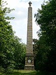 More images |
| Temple of Leod Lud about 300m due south of the Rotunda in the Black Fen Pleasure Grounds | Bramham Park, Barwick in Elmet and Scholes, Leeds | Garden Temple | Mid 18th century | 1 May 1960 | SE4132840497 53°51′33″N 1°22′23″W / 53.859058°N 1.373134°W / 53.859058; -1.373134 (Temple of Leod Lud about 300m due south of the Rotunda in the Black Fen Pleasure Grounds) | 1065978 |  More images |
| West Wing, Potterton Hall | Potterton Park, Barwick in Elmet and Scholes, Leeds | House | c. 1740 | 1 October 1982 | SE4060938994 53°50′44″N 1°23′03″W / 53.845607°N 1.384263°W / 53.845607; -1.384263 (West Wing, Potterton Hall) | 1065985 |  |
| Bramham Biggin | Bramham, Bramham cum Oglethorpe, Leeds | House | 17th century | 30 March 1966 | SE4224342310 53°52′31″N 1°21′32″W / 53.875279°N 1.358975°W / 53.875279; -1.358975 (Bramham Biggin) | 1135632 | 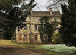 More images |
| Church of All Saints | Bramham cum Oglethorpe, Leeds | Parish Church | 12th century | 30 March 1966 | SE4271543036 53°52′54″N 1°21′06″W / 53.881765°N 1.351695°W / 53.881765; -1.351695 (Church of All Saints) | 1313180 |  More images |
| Church of St Oswald | Collingham, Leeds | Church | Slightly later than C7 | 22 July 1986 | SE3901546096 53°54′34″N 1°24′27″W / 53.909557°N 1.407588°W / 53.909557; -1.407588 (Church of St Oswald) | 1225846 | 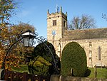 More images |
| Double Terrace to South Front of Harewood House including retaining Walls and Steps, Flower Bed Surrounds, Fountains, Garden Ornaments and Sculptures | Harewood, Leeds | Balustrade | 1847-8 | 22 July 1986 | SE3117744571 53°53′47″N 1°31′37″W / 53.89638°N 1.52705°W / 53.89638; -1.52705 (Double Terrace to South Front of Harewood House including retaining Walls and Steps, Flower Bed Surrounds, Fountains, Garden Ornaments and Sculptures) | 1226148 |  More images |
| Main Gateway, Lodges and Linking Walls to Harewood House | Harewood Park, Harewood, Leeds | Gate | 1802-4 | 30 March 1966 | SE3218844941 53°53′59″N 1°30′42″W / 53.899644°N 1.511627°W / 53.899644; -1.511627 (Main Gateway, Lodges and Linking Walls to Harewood House) | 1226352 |  More images |
| 22–27 Harrogate Road | Harewood, Leeds | House | 1966 | 30 March 1966 | SE3220845018 53°54′01″N 1°30′41″W / 53.900335°N 1.511315°W / 53.900335; -1.511315 (22–27 Harrogate Road) | 1226850 |  Upload Photo |
| 2–5 The Avenue | Harewood, Leeds | Bothy | Mid-late 18th century | 30 March 1966 | SE3236245018 53°54′01″N 1°30′32″W / 53.900325°N 1.508971°W / 53.900325; -1.508971 (2–5 The Avenue) | 1226637 |  More images |
| 6–10 The Avenue | Harewood, Leeds | Estate Cottage | Mid-late 18th century | 30 March 1966 | SE3232345013 53°54′01″N 1°30′34″W / 53.900283°N 1.509565°W / 53.900283; -1.509565 (6–10 The Avenue) | 1226819 |  |
| 11 The Avenue | Harewood, Leeds | House | 1966 | 30 March 1966 | SE3229745013 53°54′01″N 1°30′36″W / 53.900284°N 1.509961°W / 53.900284; -1.509961 (11 The Avenue) | 1226843 | Upload Photo |
| 12–15 The Avenue | Harewood, Leeds | House | 1770 | 30 March 1966 | SE3228245009 53°54′01″N 1°30′37″W / 53.900249°N 1.51019°W / 53.900249; -1.51019 (12–15 The Avenue) | 1265739 |  |
| 16 The Avenue | Harewood, Leeds | Managers House | Mid-late 18th century | 30 March 1966 | SE3225345011 53°54′01″N 1°30′38″W / 53.900269°N 1.510631°W / 53.900269; -1.510631 (16 The Avenue) | 1226651 |  |
| Garden House at North End of West Terrace of Ledston Hall | Ledston, Leeds | Garden House | c. 1720 | 4 July 1952 | SE4351228978 53°45′19″N 1°20′30″W / 53.755355°N 1.341555°W / 53.755355; -1.341555 (Garden House at North End of West Terrace of Ledston Hall) | 1237514 | Upload Photo |
| Gate Piers on Former Drive Approximately 150 Metres North of Ledston Hall | Ledston, Leeds | Gate | Mid 18th century | 4 July 1952 | SE4351929100 53°45′23″N 1°20′29″W / 53.756451°N 1.341431°W / 53.756451; -1.341431 (Gate Piers on Former Drive Approximately 150 Metres North of Ledston Hall) | 1264016 | Upload Photo |
| Lotherton Chapel | Lotherton Park, Lotherton cum Aberford, Leeds | Chapel | Late 12th century | 3 February 1967 | SE4493736036 53°49′07″N 1°19′08″W / 53.818667°N 1.318918°W / 53.818667; -1.318918 (Lotherton Chapel) | 1200687 |  More images |
| Manor Club | Otley, Leeds | House | 17th century | 30 July 1951 | SE2017545622 53°54′23″N 1°41′40″W / 53.906369°N 1.694401°W / 53.906369; -1.694401 (Manor Club) | 1200411 | 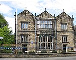 More images |
| The Old Hall | Otley, Leeds | House | 18th century or possibly 1690 | 30 July 1951 | SE2017145508 53°54′19″N 1°41′40″W / 53.905344°N 1.694469°W / 53.905344; -1.694469 (The Old Hall) | 1135236 |  More images |
| Gascoigne Almshouses and Attached Wardens Cottage | Aberford | House | 1843-5 | 4 July 1952 | SE4323636375 53°49′19″N 1°20′41″W / 53.821858°N 1.344706°W / 53.821858; -1.344706 (Gascoigne Almshouses and Attached Wardens Cottage) | 1300616 |  More images |
| Triumphal Arch | Parlington Park, Parlington, Leeds | Triumphal Arch | 1783 | 10 August 1983 | SE4218136552 53°49′25″N 1°21′39″W / 53.823535°N 1.360706°W / 53.823535; -1.360706 (Triumphal Arch) | 1135624 |  More images |
| Church of St Mary | Swillington, Leeds | Parish Church | Late 14th century | 3 February 1967 | SE3849430469 53°46′09″N 1°25′03″W / 53.769149°N 1.41747°W / 53.769149; -1.41747 (Church of St Mary) | 1247710 |  More images |
| Leventhorpe Hall | Swillington, Leeds | House | 1774 | 5 July 1978 | SE3687730037 53°45′55″N 1°26′31″W / 53.765383°N 1.442053°W / 53.765383; -1.442053 (Leventhorpe Hall) | 1247691 | Upload Photo |
| Thorp Arch Hall Including East Wing and West Wing | Thorp Arch, Leeds | House | 1988 | 30 March 1966 | SE4295946284 53°54′39″N 1°20′51″W / 53.910936°N 1.347529°W / 53.910936; -1.347529 (Thorp Arch Hall Including East Wing and West Wing) | 1116216 | Upload Photo |
| Church of St Peter | Walton, Leeds | Church | 12th century | 30 March 1966 | SE4411447819 53°55′29″N 1°19′47″W / 53.924634°N 1.329727°W / 53.924634; -1.329727 (Church of St Peter) | 1115540 | 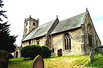 More images |
| Adult Education Centre, University of Leeds | University Campus, Leeds | Hostel | 1908-1928 | 26 September 1963 | SE2911834372 53°48′17″N 1°33′34″W / 53.804835°N 1.559345°W / 53.804835; -1.559345 (Adult Education Centre, University of Leeds) | 1256039 |  More images |
| Armley Mills Main Range | Armley, Leeds | Bridge | 1797 | 19 October 1951 | SE2756434137 53°48′10″N 1°34′59″W / 53.802807°N 1.582962°W / 53.802807; -1.582962 (Armley Mills Main Range) | 1255747 |  More images |
| Armley Prison: Entrance Range and Flanking Walls | Armley, Leeds | Tower | 1847 | 5 August 1976 | SE2805533360 53°47′45″N 1°34′32″W / 53.795797°N 1.575577°W / 53.795797; -1.575577 (Armley Prison: Entrance Range and Flanking Walls) | 1256248 |  More images |
| Armley Prison: Inner Range | Armley, Leeds | Steps | 1847 | 5 August 1976 | SE2795633352 53°47′45″N 1°34′37″W / 53.795731°N 1.577081°W / 53.795731; -1.577081 (Armley Prison: Inner Range) | 1256249 | Upload Photo |
| Armley Prison: Revetment Wall on East Side of Gloucester Terrace | Armley, Leeds | Prison | c1847 (After 1847) | 5 October 1994 | SE2806233382 53°47′46″N 1°34′32″W / 53.795995°N 1.575469°W / 53.795995; -1.575469 (Armley Prison: Revetment Wall on East Side of Gloucester Terrace) | 1256250 | Upload Photo |
| Austhorpe Hall | Austhorpe, Leeds | Country House | 1694 | 26 September 1963 | SE3698634131 53°48′08″N 1°26′24″W / 53.802171°N 1.43991°W / 53.802171; -1.43991 (Austhorpe Hall) | 1256314 | 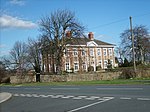 More images |
| Chadwick Lodge and Attached Walls and Railings | Leeds | House | Late 18th century | 26 September 1963 | SE3066932998 53°47′33″N 1°32′09″W / 53.792397°N 1.535931°W / 53.792397; -1.535931 (Chadwick Lodge and Attached Walls and Railings) | 1375265 |  More images |
| Church House | Calverley, Leeds | Semi Detached House | Mid 18th century | 25 May 1966 | SE2079337157 53°49′49″N 1°41′08″W / 53.830263°N 1.685565°W / 53.830263; -1.685565 (Church House) | 1266011 |  More images |
| Church of All Souls with Boundary Wall and War Memorial | Leeds | Church | 1876-1880 | 26 September 1963 | SE2994334722 53°48′29″N 1°32′48″W / 53.807934°N 1.546785°W / 53.807934; -1.546785 (Church of All Souls with Boundary Wall and War Memorial) | 1255888 |  More images |
| Church of St Aidan | Harehills, Leeds | Anglican Church | 1891-1894 | 26 September 1963 | SE3165635254 53°48′45″N 1°31′15″W / 53.812614°N 1.520719°W / 53.812614; -1.520719 (Church of St Aidan) | 1256175 |  More images |
| Church of St Bartholomew | Armley, Leeds | Anglican Church | 1872-1877 | 26 September 1963 | SE2730133209 53°47′40″N 1°35′13″W / 53.79448°N 1.587037°W / 53.79448; -1.587037 (Church of St Bartholomew) | 1255697 |  More images |
| Church of St Chad | Far Headingley, Leeds | Church | 1868 | 26 September 1963 | SE2733536897 53°49′39″N 1°35′10″W / 53.827625°N 1.586195°W / 53.827625; -1.586195 (Church of St Chad) | 1375301 | 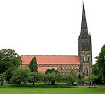 More images |
| Church of St John the Evangelist | Oulton | Church | 1827-9 | 5 June 1964 | SE3597228095 53°44′53″N 1°27′22″W / 53.747993°N 1.456006°W / 53.747993; -1.456006 (Church of St John the Evangelist) | 1135676 |  More images |
| Church of St Margaret of Antioch | Burley, Leeds | Anglican Church | 1908-1909 | 26 August 1963 | SE2813934931 53°48′36″N 1°34′27″W / 53.809913°N 1.574159°W / 53.809913; -1.574159 (Church of St Margaret of Antioch) | 1255673 |  More images |
| Church of St Matthew | Chapel Allerton, Leeds | Anglican Church | 1897-1898 | 23 September 1963 | SE3030237373 53°49′54″N 1°32′28″W / 53.831739°N 1.541073°W / 53.831739; -1.541073 (Church of St Matthew) | 1255680 |  More images |
| Church of St Matthias | Burley, Leeds | Anglican Church | 1854 | 5 August 1976 | SE2781334599 53°48′25″N 1°34′45″W / 53.806946°N 1.57914°W / 53.806946; -1.57914 (Church of St Matthias) | 1256114 |  More images |
| Church of St Michael | Headingley, Leeds | Anglican Church | 1884-5 | 26 September 1963 | SE2801135957 53°49′09″N 1°34′34″W / 53.819141°N 1.57601°W / 53.819141; -1.57601 (Church of St Michael) | 1255967 | 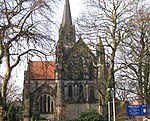 More images |
| Church of St Wilfrid | Calverley, Leeds | Church | 1154 | 25 May 1966 | SE2083437172 53°49′49″N 1°41′06″W / 53.830397°N 1.684941°W / 53.830397; -1.684941 (Church of St Wilfrid) | 1226034 | 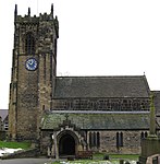 More images |
| Church of St Wilfrid | Halton, Leeds | Anglican Church | 1938 | 19 March 1981 | SE3470233680 53°47′54″N 1°28′29″W / 53.798274°N 1.474637°W / 53.798274; -1.474637 (Church of St Wilfrid) | 1256092 | 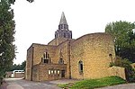 More images |
| Leeds City Varieties | Leeds | Music Hall | Late 18th century | 15 February 1960 | SE3020933721 53°47′56″N 1°32′34″W / 53.798922°N 1.542843°W / 53.798922; -1.542843 (Leeds City Varieties) | 1255972 |  More images |
| Civic Court and Attached Railings | Leeds | Drawing Office | 1879-1881 | 26 September 1963 | SE2982533908 53°48′02″N 1°32′55″W / 53.800625°N 1.548655°W / 53.800625; -1.548655 (Civic Court and Attached Railings) | 1255773 |  More images |
| Civic Hall | Leeds | Town Hall | 1933 | 5 August 1976 | SE2983434081 53°48′08″N 1°32′55″W / 53.802179°N 1.548502°W / 53.802179; -1.548502 (Civic Hall) | 1255781 |  More images |
| Denison Hall | Leeds | Villa | 1786 | 19 October 1951 | SE2909234083 53°48′08″N 1°33′35″W / 53.802239°N 1.559767°W / 53.802239; -1.559767 (Denison Hall) | 1256073 |  More images |
| East Ardsley Old Hall | East Ardsley, Leeds | House | 1632 | 3 July 1985 | SE3056825268 53°43′23″N 1°32′18″W / 53.722928°N 1.538227°W / 53.722928; -1.538227 (East Ardsley Old Hall) | 1250736 |  More images |
| First Leeds Cloth Hall | Leeds | Cloth Hall | 1711 | 16 June 1983 | SE3044733422 53°47′46″N 1°32′21″W / 53.796221°N 1.53926°W / 53.796221; -1.53926 (First Leeds Cloth Hall) | 1375042 |  More images |
| Former Flax Warehouse to Marshall's Mill | Holbeck, Leeds | Shop | 1808 | 9 March 1987 | SE2949532887 53°47′29″N 1°33′14″W / 53.791467°N 1.553763°W / 53.791467; -1.553763 (Former Flax Warehouse to Marshall's Mill) | 1375161 | 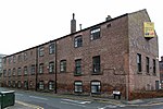 |
| Former Foundry Building for Fenton Murray and Wood Engineers | Holbeck, Leeds | Foundry | c. 1795 | 25 August 1987 | SE2960732900 53°47′30″N 1°33′07″W / 53.791578°N 1.552061°W / 53.791578; -1.552061 (Former Foundry Building for Fenton Murray and Wood Engineers) | 1375467 |  |
| Former Machine and Fitting Shops for Fenton Murray and Wood Engineers | Holbeck, Leeds | Fitters Workshop | Extension by | 25 August 1987 | SE2961232872 53°47′29″N 1°33′07″W / 53.791326°N 1.551988°W / 53.791326; -1.551988 (Former Machine and Fitting Shops for Fenton Murray and Wood Engineers) | 1375468 | |
| Former Leeds and Liverpool Canal Company Warehouse | Leeds | Fireproof Building | Mid/Late 19th century | 5 August 1976 | SE2984033030 53°47′34″N 1°32′55″W / 53.792733°N 1.548512°W / 53.792733; -1.548512 (Former Leeds and Liverpool Canal Company Warehouse) | 1255696 |  |
| Gate Lodge to Temple Mill | Holbeck, Leeds | Gate Lodge | 1843 | 19 October 1951 | SE2955032766 53°47′25″N 1°33′11″W / 53.790376°N 1.552939°W / 53.790376; -1.552939 (Gate Lodge to Temple Mill) | 1375166 |  |
| Gatehouse at Kirkstall Abbey (Abbey House Museum) | Kirkstall, Leeds | Abbey | 12th century | 26 September 1963 | SE2596136293 53°49′20″N 1°36′26″W / 53.822267°N 1.607119°W / 53.822267; -1.607119 (Gatehouse at Kirkstall Abbey (Abbey House Museum)) | 1256646 |  More images |
| Gazebo approx. 100 Metres North of Clumpcliffe Farmhouse | Methley, Leeds | Gazebo | 1708 | 5 June 1964 | SE3699026986 53°44′17″N 1°26′27″W / 53.737954°N 1.440703°W / 53.737954; -1.440703 (Gazebo approx. 100 Metres North of Clumpcliffe Farmhouse) | 1135669 | Upload Photo |
| Gledhow Hall | Gledhow, Leeds | Apartment | 18th century | 22 September 1975 | SE3156637049 53°49′44″N 1°31′19″W / 53.828752°N 1.521902°W / 53.828752; -1.521902 (Gledhow Hall) | 1256270 |  More images |
| Grand Theatre Including Former Assembly Rooms | Leeds | Assembly Rooms | 1877-1878 | 15 February 1960 | SE3032033834 53°48′00″N 1°32′28″W / 53.799931°N 1.541147°W / 53.799931; -1.541147 (Grand Theatre Including Former Assembly Rooms) | 1375219 |  More images |
| Hawksworth Hall | Hawksworth, Guiseley, Leeds | House | Early 16th century | 19 October 1962 | SE1690341692 53°52′16″N 1°44′40″W / 53.871163°N 1.744419°W / 53.871163; -1.744419 (Hawksworth Hall) | 1251067 |  More images |
| Hunslet Mill | Hunslet, Leeds | Flax Mill | c1842 (after 1838) | 10 January 1986 | SE3130432156 53°47′05″N 1°31′35″W / 53.784792°N 1.526378°W / 53.784792; -1.526378 (Hunslet Mill) | 1256253 |  More images |
| Leeds Civic Theatre and College of Music | Leeds | Municipal building | 1865-1868 | 19 October 1951 | SE2995334037 53°48′06″N 1°32′48″W / 53.801777°N 1.546699°W / 53.801777; -1.546699 (Leeds Civic Theatre and College of Music) | 1375225 |  More images |
| Leeds Club Premises and Basement Railings | Leeds | Club | 1863 | 18 May 2000 | SE3010933614 53°47′53″N 1°32′40″W / 53.797966°N 1.544372°W / 53.797966; -1.544372 (Leeds Club Premises and Basement Railings) | 1256654 |  More images |
| Marshall Mills | Holbeck, Leeds | Flax Mill | 1817 | 9 March 1987 | SE2953432799 53°47′26″N 1°33′11″W / 53.790674°N 1.553179°W / 53.790674; -1.553179 (Marshall Mills) | 1375160 |  More images |
| Memorial to Queen Victoria | Woodhouse Moor, Leeds | Commemorative Monument | 1903 | 5 August 1976 | SE2920735070 53°48′40″N 1°33′29″W / 53.811103°N 1.557928°W / 53.811103; -1.557928 (Memorial to Queen Victoria) | 1255642 |  More images |
| Mill Hill Chapel | Leeds | Church Hall | c. 1960 | 26 September 1963 | SE2996633476 53°47′48″N 1°32′48″W / 53.796734°N 1.546556°W / 53.796734; -1.546556 (Mill Hill Chapel) | 1375430 | 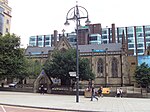 More images |
| Municipal Buildings Including City Museum, Public Library and Attached Railings | Leeds | Local Government Office | 1878-1884 | 26 September 1963 | SE2982433849 53°48′00″N 1°32′55″W / 53.800094°N 1.548676°W / 53.800094; -1.548676 (Municipal Buildings Including City Museum, Public Library and Attached Railings) | 1255783 |  More images |
| Nesbit Hall | Leeds | House | Pre 1761 | 30 June 1982 | SE2148632090 53°47′05″N 1°40′31″W / 53.784694°N 1.675388°W / 53.784694; -1.675388 (Nesbit Hall) | 1135082 |  More images |
| Newlay Bridge | Newlay, Leeds | Road Bridge | 1819 | 5 August 1976 | SE2387836940 53°49′41″N 1°38′19″W / 53.828181°N 1.638711°W / 53.828181; -1.638711 (Newlay Bridge) | 1375481 | 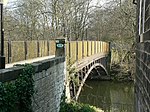 More images |
| Numbers 1-43 and Cross Arcade | Leeds | Gate | 1900 | 25 April 1974 | SE3032233653 53°47′54″N 1°32′28″W / 53.798304°N 1.541134°W / 53.798304; -1.541134 (Numbers 1-43 and Cross Arcade) | 1256197 |  |
| 16-20 Commercial St, Leeds including Leeds Library (18) | Leeds | Shop | 1808 | 19 October 1951 | SE3010433559 53°47′51″N 1°32′40″W / 53.797472°N 1.544453°W / 53.797472; -1.544453 (16-20 Commercial St, Leeds including Leeds Library (18)) | 1375154 |  More images |
| 228 and 230, Leeds Road | Lofthouse, Leeds | Farmhouse | Mid 17th century | 5 June 1964 | SE3328626124 53°43′50″N 1°29′49″W / 53.730456°N 1.496946°W / 53.730456; -1.496946 (228 and 230, Leeds Road) | 1313491 |  More images |
| Rawdon Hall | Aireborough, Leeds | House | 17th century | 19 October 1962 | SE2115639169 53°50′54″N 1°40′48″W / 53.848332°N 1.679912°W / 53.848332; -1.679912 (Rawdon Hall) | 1281301 | Upload Photo |
| Rectory Hall | Aireborough, Leeds | House | 1962 | 19 October 1962 | SE1949942092 53°52′29″N 1°42′18″W / 53.874668°N 1.704913°W / 53.874668; -1.704913 (Rectory Hall) | 1262939 | Upload Photo |
| Remains of North West Range of White Cloth Hall including Entrance | Leeds | Cloth Hall | 1776 | 19 October 1951 | SE3041733348 53°47′44″N 1°32′23″W / 53.795557°N 1.539722°W / 53.795557; -1.539722 (Remains of North West Range of White Cloth Hall including Entrance) | 1375283 |  |
| River Lock and Retaining Walls to River Aire | Leeds | River Lock | 1770-1776 | 7 December 1992 | SE2984633044 53°47′34″N 1°32′54″W / 53.792858°N 1.54842°W / 53.792858; -1.54842 (River Lock and Retaining Walls to River Aire) | 1255707 | 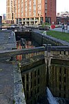 |
| Roger Stevens Building | Leeds | University | 1970 | 10 June 2010 | SE2943134378 53°48′18″N 1°33′17″W / 53.804871°N 1.554592°W / 53.804871; -1.554592 (Roger Stevens Building) | 1393836 |  More images |
| Roman Catholic Cathedral of St Anne | Leeds | Priests House | 1902-1904 | 26 September 1963 | SE2994733908 53°48′02″N 1°32′48″W / 53.800618°N 1.546803°W / 53.800618; -1.546803 (Roman Catholic Cathedral of St Anne) | 1375230 |  More images |
| Spenfield | Weetwood, Leeds | House | c. 1890 | 5 May 1975 | SE2699237568 53°50′01″N 1°35′29″W / 53.833674°N 1.591347°W / 53.833674; -1.591347 (Spenfield) | 1375329 |  More images |
| St Mary's Convent Church | Richmond Hill, Leeds | Roman Catholic Church | 1852 | 5 August 1976 | SE3130433169 53°47′38″N 1°31′35″W / 53.793896°N 1.526275°W / 53.793896; -1.526275 (St Mary's Convent Church) | 1255558 |  More images |
| St Paul's House and Attached Railings and Gates | Leeds | Gate | 1878 | 26 September 1963 | SE2956933664 53°47′54″N 1°33′09″W / 53.798446°N 1.552565°W / 53.798446; -1.552565 (St Paul's House and Attached Railings and Gates) | 1256126 |  More images |
| Stables at Temple Newsam | Temple Newsam, Leeds | Workshop | 1951 | 19 October 1951 | SE3580932186 53°47′05″N 1°27′29″W / 53.784772°N 1.458005°W / 53.784772; -1.458005 (Stables at Temple Newsam) | 1255954 |  More images |
| Stank Hall Barn | Beeston, Leeds | Chapel | 17th century | 19 October 1951 | SE2853529139 53°45′28″N 1°34′07″W / 53.757834°N 1.56868°W / 53.757834; -1.56868 (Stank Hall Barn) | 1375339 |  More images |
| Statue of the Black Prince | Leeds City Square | Statue | 1903 | 26 September 1963 | SE2989833434 53°47′47″N 1°32′51″W / 53.79636°N 1.547593°W / 53.79636; -1.547593 (Statue of the Black Prince) | 1375045 |  More images |
| The Garden Gate Public House | Leeds | Public House | 1902-1903 | 21 February 1972 | SE3120231672 53°46′50″N 1°31′41″W / 53.780448°N 1.527975°W / 53.780448; -1.527975 (The Garden Gate Public House) | 1255677 |  More images |
| The Grange | Beckett Park, Leeds | Country House | 1752 | 19 October 1951 | SE2679436689 53°49′33″N 1°35′40″W / 53.825784°N 1.594432°W / 53.825784; -1.594432 (The Grange) | 1256304 |  More images |
| The Manor House, Cad Beeston | Beeston Hill, Leeds | House | Early 19th century | 7 October 1985 | SE2922931429 53°46′42″N 1°33′29″W / 53.778378°N 1.557938°W / 53.778378; -1.557938 (The Manor House, Cad Beeston) | 1255940 | Upload Photo |
| The Nookin | Oulton, Leeds | House | 1611 | 27 May 1960 | SE3592728326 53°45′00″N 1°27′24″W / 53.750072°N 1.456662°W / 53.750072; -1.456662 (The Nookin) | 1135675 |  More images |
| The Round House (Leeds Commercial Van and Truck Rental Premises) | Leeds | Garage | C20 | 19 June 1986 | SE2878833213 53°47′40″N 1°33′52″W / 53.794436°N 1.564464°W / 53.794436; -1.564464 (The Round House (Leeds Commercial Van and Truck Rental Premises)) | 1255725 |  More images |
| Thorpe Hall | Thorpe on the Hill, Leeds | House | 1735 | 5 June 1964 | SE3161027009 53°44′19″N 1°31′20″W / 53.738514°N 1.522259°W / 53.738514; -1.522259 (Thorpe Hall) | 1135039 | Upload Photo |
| Time Ball Buildings | Leeds | House | Early 19th century | 22 March 1974 | SE3021333361 53°47′44″N 1°32′34″W / 53.795686°N 1.542818°W / 53.795686; -1.542818 (Time Ball Buildings) | 1255855 |  More images |
| Tower Works, Boiler House Chimney | Holbeck, Leeds | Chimney | 1864 | 5 August 1976 | SE2958833018 53°47′34″N 1°33′08″W / 53.792639°N 1.552338°W / 53.792639; -1.552338 (Tower Works, Boiler House Chimney) | 1256246 |  |
| Tower Works, the Giotto Tower Dust Extraction Chimney | Holbeck, Leeds | Chimney | 1899 | 5 August 1976 | SE2954832998 53°47′33″N 1°33′11″W / 53.792462°N 1.552947°W / 53.792462; -1.552947 (Tower Works, the Giotto Tower Dust Extraction Chimney) | 1256247 | 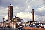 |
| Tyersal Hall | Bradford, Leeds | House | Late 16th century | 25 May 1966 | SE2004432223 53°47′09″N 1°41′50″W / 53.785947°N 1.697264°W / 53.785947; -1.697264 (Tyersal Hall) | 1135123 |  More images |
| University of Leeds School of Medicine | Thoresby Place, Leeds | Medical College | 1894 | 22 March 1974 | SE2954634053 53°48′07″N 1°33′10″W / 53.801944°N 1.552877°W / 53.801944; -1.552877 (University of Leeds School of Medicine) | 1255833 |  More images |
| Waterloo House, North East Range of White Cloth Hall with Assembly Rooms over | Leeds | Assembly Rooms | 1777 | 5 August 1976 | SE3045633370 53°47′45″N 1°32′21″W / 53.795753°N 1.539128°W / 53.795753; -1.539128 (Waterloo House, North East Range of White Cloth Hall with Assembly Rooms over) | 1375290 |  More images |
| Weetwood Hall | Weetwood, Leeds | House | 1625 | 19 October 1951 | SE2698638029 53°50′16″N 1°35′29″W / 53.837817°N 1.591398°W / 53.837817; -1.591398 (Weetwood Hall) | 1375330 |  More images |
| Whitelock's Ale House | Leeds | Pub | c.1700 | 29 September 1963 | 53°47′50″N 1°32′35″W / 53.79722°N 1.54312°W / 53.79722; -1.54312 (Whitelock's Ale House) | 1255825 |  More images |
| 99 Water Lane | Holbeck, Leeds | Garage | Late 19th century | 7 July 1995 | SE2964132901 53°47′30″N 1°33′06″W / 53.791585°N 1.551545°W / 53.791585; -1.551545 (99 Water Lane) | 1255779 | More images |
| 32–36 Commercial Street | Rothwell, Leeds | Manor House | Late 16th century or early 17th century | 5 June 1964 | SE3456728152 53°44′55″N 1°28′38″W / 53.7486°N 1.477304°W / 53.7486; -1.477304 (32–36 Commercial Street) | 1135680 |  |
Notes
- ^ The date given is the date used by Historic England as significant for the initial building or that of an important part in the structure's description.
- ^ Sometimes known as OSGB36, the grid reference is based on the British national grid reference system used by the Ordnance Survey.
- ^ The "List Entry Number" is a unique number assigned to each listed building and scheduled monument by Historic England.
- v
- t
- e
- Bedfordshire
- Berkshire
- Bristol
- Buckinghamshire
- Cambridgeshire
- Cheshire
- Cornwall
- Cumbria
- Derbyshire
- Devon
- Dorset
- Durham
- East Sussex
- East Riding of Yorkshire
- Essex
- Gloucestershire
- Greater London
- Greater Manchester
- Hampshire
- Herefordshire
- Hertfordshire
- Isle of Wight
- Kent
- Lancashire
- Leicestershire
- Lincolnshire
- Merseyside
- Norfolk
- North Yorkshire
- Northamptonshire
- Northumberland
- Nottinghamshire
- Oxfordshire
- Rutland
- Shropshire
- Somerset
- South Yorkshire
- Staffordshire
- Suffolk
- Surrey
- Tyne and Wear
- Warwickshire
- West Midlands
- West Sussex
- West Yorkshire
- Wiltshire
- Worcestershire
- Allerdale
- Amber Valley
- Ashford
- Babergh
- Barrow-in-Furness
- Basildon
- Basingstoke and Deane
- Bath and North East Somerset
- Bolsover
- Boston
- Bournemouth
- Bradford
- Braintree
- Breckland
- Brentwood
- Brighton and Hove
- Bristol
- Broadland
- Calderdale
- Cambridge
- Camden
- Canterbury
- Carlisle
- Castle Point
- Chelmsford
- Cheltenham
- Cherwell
- Cheshire East
- Cheshire West and Chester
- Chesterfield
- Chiltern
- Christchurch
- Colchester
- Copeland
- Corby
- Cotswold
- Dartford
- Daventry
- Dover
- East Cambridgeshire
- Exeter
- Mendip
- North Somerset
- North Yorkshire (district)
- Poole
- Sedgemoor
- South Somerset
- Stoke-on-Trent
- Taunton Deane
- West Somerset
- York


