Grade II* listed buildings in South Bucks
Map all coordinates using OpenStreetMap
Download coordinates as:
- KML
- GPX (all coordinates)
- GPX (primary coordinates)
- GPX (secondary coordinates)
There are over 20,000 Grade II* listed buildings in England. This page is a list of these buildings in the district of South Bucks in Buckinghamshire.
List
| Name | Location | Type | Completed [note 1] | Date designated | Grid ref.[note 2] Geo-coordinates | Entry number [note 3] | Image |
|---|---|---|---|---|---|---|---|
| Africa House, Burke Lodge | Beaconsfield, South Bucks | House | C16/C17 | 19 May 1950 | SU9460290085 51°36′06″N 0°38′08″W / 51.60167°N 0.635474°W / 51.60167; -0.635474 (Africa House, Burke Lodge) | 1124572 | |
| Boathouse at Foot of Lake at Hall Barn | Hall Barn Estate, Beaconsfield | Boat House | Early 18th century | 24 April 1985 | SU9424088968 51°35′30″N 0°38′28″W / 51.59169°N 0.640999°W / 51.59169; -0.640999 (Boathouse at Foot of Lake at Hall Barn) | 1310579 |  Upload Photo |
| Hall Barn | Hall Barn Estate, Beaconsfield | Country House | Post 1651 | 19 May 1950 | SU9434289223 51°35′38″N 0°38′22″W / 51.593966°N 0.639459°W / 51.593966; -0.639459 (Hall Barn) | 1160418 | More images |
| Obelisk at Hall Barn | Hall Barn Estate, Beaconsfield | Obelisk | Early 18th century | 24 April 1985 | SU9387089182 51°35′37″N 0°38′47″W / 51.593676°N 0.646281°W / 51.593676; -0.646281 (Obelisk at Hall Barn) | 1310581 | Upload Photo |
| Temple of Venus at Hall Barn | Hall Barn Estate, Beaconsfield | Temple | Early 18th century | 19 May 1950 | SU9391688964 51°35′30″N 0°38′44″W / 51.591709°N 0.645676°W / 51.591709; -0.645676 (Temple of Venus at Hall Barn) | 1332613 | Upload Photo |
| Hall Place | Beaconsfield | House | 18th century | 19 May 1950 | SU9441290039 51°36′05″N 0°38′18″W / 51.601289°N 0.638229°W / 51.601289; -0.638229 (Hall Place) | 1124518 | Upload Photo |
| Parish Church of St Mary and All Saints | Beaconsfield | Parish Church | Late 15th century | 19 May 1950 | SU9449090003 51°36′03″N 0°38′14″W / 51.600952°N 0.637113°W / 51.600952; -0.637113 (Parish Church of St Mary and All Saints) | 1124547 | More images |
| The Old Rectory (adjoining West Side of Churchyard) | Beaconsfield | Vicarage | 16th century | 19 May 1950 | SU9452889904 51°36′00″N 0°38′12″W / 51.600056°N 0.636591°W / 51.600056; -0.636591 (The Old Rectory (adjoining West Side of Churchyard)) | 1160916 | |
| Tomb of Edmund Waller South East of Parish Church of St Mary and All Saints | Beaconsfield | Obelisk | 1687 | 24 April 1985 | SU9452389980 51°36′03″N 0°38′12″W / 51.60074°N 0.636643°W / 51.60074; -0.636643 (Tomb of Edmund Waller South East of Parish Church of St Mary and All Saints) | 1160900 |  |
| Burnham Beeches Hotel: Entrance Gates and Curtain Walls | Burnham | Gate | 18th century | 24 April 1985 | SU9383983139 51°32′22″N 0°38′54″W / 51.539361°N 0.64834°W / 51.539361; -0.64834 (Burnham Beeches Hotel: Entrance Gates and Curtain Walls) | 1124496 | Upload Photo |
| Church of St Anne | Littleworth Common, Burnham | Church | 1866 | 23 September 1955 | SU9345086457 51°34′09″N 0°39′11″W / 51.569251°N 0.653067°W / 51.569251; -0.653067 (Church of St Anne) | 1124522 |  More images |
| Church of St Peter | Burnham | Parish Church | 13th century | 23 September 1955 | SU9305682397 51°31′58″N 0°39′35″W / 51.532821°N 0.659823°W / 51.532821; -0.659823 (Church of St Peter) | 1124528 |  More images |
| Nashdom | Burnham | House | Modern | 23 September 1955 | SU9199384292 51°33′00″N 0°40′29″W / 51.550029°N 0.674649°W / 51.550029; -0.674649 (Nashdom) | 1332673 |  More images |
| Footbridge across River Colne, to South of Denham Court | Denham Court, Denham | Footbridge | c. 1850 | 30 May 1986 | TQ0515187330 51°34′30″N 0°29′03″W / 51.575039°N 0.48404°W / 51.575039; -0.48404 (Footbridge across River Colne, to South of Denham Court) | 1200391 | Upload Photo |
| Hills House | Denham | House | Late 17th century | 23 September 1955 | TQ0424387024 51°34′21″N 0°29′50″W / 51.572457°N 0.497229°W / 51.572457; -0.497229 (Hills House) | 1332704 |  More images |
| Church of St James | Fulmer | Parish Church | 1610 | 23 September 1955 | SU9990485689 51°33′40″N 0°33′37″W / 51.561242°N 0.560195°W / 51.561242; -0.560195 (Church of St James) | 1124420 | 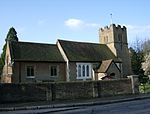 More images |
| Church of St James | Gerrards Cross | Bell Tower | 1859 | 23 September 1955 | TQ0009387924 51°34′53″N 0°33′25″W / 51.581298°N 0.556834°W / 51.581298; -0.556834 (Church of St James) | 1124389 |  More images |
| Shell House | Hedgerley | House | Late 17th century | 23 September 1955 | SU9701487673 51°34′46″N 0°36′05″W / 51.57958°N 0.601325°W / 51.57958; -0.601325 (Shell House) | 1124399 | Upload Photo |
| The Old Quaker House and Garden Wall | Hedgerley | House | 16th century | 23 September 1955 | SU9694187453 51°34′39″N 0°36′09″W / 51.577615°N 0.602439°W / 51.577615; -0.602439 (The Old Quaker House and Garden Wall) | 1317834 | Upload Photo |
| Bridgefoot House | Iver | House | Early 18th century | 23 September 1955 | TQ0408981362 51°31′18″N 0°30′04″W / 51.521594°N 0.501123°W / 51.521594; -0.501123 (Bridgefoot House) | 1332738 | Upload Photo |
| Dairy in Grounds of Elk Meadows | Iver | Cottage Ornee | Early 19th century | 26 April 1985 | TQ0396482968 51°32′10″N 0°30′09″W / 51.536052°N 0.502451°W / 51.536052; -0.502451 (Dairy in Grounds of Elk Meadows) | 1164777 | Upload Photo |
| Iver Grove | Shreding Green, Iver | House | 1722-1724 | 27 November 1954 | TQ0240681107 51°31′11″N 0°31′32″W / 51.519609°N 0.525446°W / 51.519609; -0.525446 (Iver Grove) | 1124384 |  More images |
| Entrance Gates, Lamps and Lodges to Stoke Park | Stoke Poges | Gate Lodge | c. 1800 | 26 April 1985 | SU9746682332 51°31′53″N 0°35′47″W / 51.531494°N 0.596283°W / 51.531494; -0.596283 (Entrance Gates, Lamps and Lodges to Stoke Park) | 1124347 | Upload Photo |
| Gray's Monument | Stoke Poges | Sarcophagus | 1799 | 23 September 1955 | SU9778782667 51°32′04″N 0°35′30″W / 51.534449°N 0.591564°W / 51.534449; -0.591564 (Gray's Monument) | 1124346 | 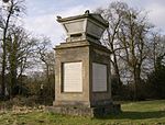 More images |
| Stoke Park Bridge | Stoke Park, Stoke Poges | Bridge | 1798 | 23 September 1955 | SU9727382636 51°32′03″N 0°35′56″W / 51.534259°N 0.59898°W / 51.534259; -0.59898 (Stoke Park Bridge) | 1124358 |  More images |
| Balustrade from the Villa Borghese, Rome, to the South of Cliveden | Taplow | Balustrade | 1618 | 23 September 1955 | SU9103585125 51°33′28″N 0°41′18″W / 51.557672°N 0.688246°W / 51.557672; -0.688246 (Balustrade from the Villa Borghese, Rome, to the South of Cliveden) | 1332434 |  |
| Shell Fountain, Cliveden | Cliveden, Taplow, South Bucks | Shell Fountain | 1897 | 26 April 1985 | SU9108385565 51°33′42″N 0°41′15″W / 51.56162°N 0.68744°W / 51.56162; -0.68744 (Shell Fountain, Cliveden) | 1125047 |  More images |
| Stable Buildings at Cliveden | Cliveden, Taplow | Loggia | 1861 | 23 September 1955 | SU9096785266 51°33′32″N 0°41′21″W / 51.558951°N 0.68919°W / 51.558951; -0.68919 (Stable Buildings at Cliveden) | 1125043 | Upload Photo |
| Langley Park including Quadrant Walls, Corner Towers, Pavilions and Orangery. | Langley Park, Wexham | Apartment | 1983 | 18 July 1972 | TQ0090981591 51°31′27″N 0°32′49″W / 51.524229°N 0.546876°W / 51.524229; -0.546876 (Langley Park including Quadrant Walls, Corner Towers, Pavilions and Orangery.) | 1125028 | 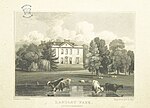 More images |
| Parish Church of St Mary | Wexham, South Bucks | Parish Church | 12th century | 26 April 1985 | SU9927181512 51°31′26″N 0°34′14″W / 51.523809°N 0.570501°W / 51.523809; -0.570501 (Parish Church of St Mary) | 1309053 |  More images |
Notes
- ^ The date given is the date used by Historic England as significant for the initial building or that of an important part in the structure's description.
- ^ Sometimes known as OSGB36, the grid reference is based on the British national grid reference system used by the Ordnance Survey.
- ^ The "List Entry Number" is a unique number assigned to each listed building and scheduled monument by Historic England.
External links
- v
- t
- e
- Bedfordshire
- Berkshire
- Bristol
- Buckinghamshire
- Cambridgeshire
- Cheshire
- Cornwall
- Cumbria
- Derbyshire
- Devon
- Dorset
- Durham
- East Sussex
- East Riding of Yorkshire
- Essex
- Gloucestershire
- Greater London
- Greater Manchester
- Hampshire
- Herefordshire
- Hertfordshire
- Isle of Wight
- Kent
- Lancashire
- Leicestershire
- Lincolnshire
- Merseyside
- Norfolk
- North Yorkshire
- Northamptonshire
- Northumberland
- Nottinghamshire
- Oxfordshire
- Rutland
- Shropshire
- Somerset
- South Yorkshire
- Staffordshire
- Suffolk
- Surrey
- Tyne and Wear
- Warwickshire
- West Midlands
- West Sussex
- West Yorkshire
- Wiltshire
- Worcestershire
- Allerdale
- Amber Valley
- Ashford
- Babergh
- Barrow-in-Furness
- Basildon
- Basingstoke and Deane
- Bath and North East Somerset
- Bolsover
- Boston
- Bournemouth
- Bradford
- Braintree
- Breckland
- Brentwood
- Brighton and Hove
- Bristol
- Broadland
- Calderdale
- Cambridge
- Camden
- Canterbury
- Carlisle
- Castle Point
- Chelmsford
- Cheltenham
- Cherwell
- Cheshire East
- Cheshire West and Chester
- Chesterfield
- Chiltern
- Christchurch
- Colchester
- Copeland
- Corby
- Cotswold
- Dartford
- Daventry
- Dover
- East Cambridgeshire
- Exeter
- Mendip
- North Somerset
- North Yorkshire (district)
- Poole
- Sedgemoor
- South Somerset
- Stoke-on-Trent
- Taunton Deane
- West Somerset
- York


