Grade I listed buildings in Plymouth
Map all coordinates using OpenStreetMap
Download coordinates as:
- KML
- GPX (all coordinates)
- GPX (primary coordinates)
- GPX (secondary coordinates)
There are over 9,000 Grade I listed buildings in England. This page is a list of these buildings in the district of Plymouth in Devon.
City of Plymouth
| Name | Location | Type | Completed [note 1] | Date designated | Grid ref.[note 2] Geo-coordinates | Entry number [note 3] | Image |
|---|---|---|---|---|---|---|---|
| Boringdon Hall | Boringdon, City of Plymouth | Great House | Medieval | 20 February 1952 | SX5393157780 50°24′06″N 4°03′24″W / 50.401696°N 4.056712°W / 50.401696; -4.056712 (Boringdon Hall) | 1330575 | 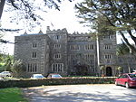 More images |
| Brewhouse, Royal William Victualling Yard | Stonehouse, Plymouth | Ordnance Factory | 1929 | 13 August 1999 | SX4601653553 50°21′42″N 4°09′59″W / 50.361687°N 4.166271°W / 50.361687; -4.166271 (Brewhouse, Royal William Victualling Yard) | 1378528 |  |
| Charles Church | City of Plymouth | Parish Church | 1640–1658 | 25 January 1954 | SX4821654605 50°22′18″N 4°08′09″W / 50.371713°N 4.135788°W / 50.371713; -4.135788 (Charles Church) | 1130021 |  More images |
| Church of St Andrew | City of Plymouth | Parish Church | Mid to Late 15th century | 25 January 1954 | SX4792054395 50°22′11″N 4°08′24″W / 50.369749°N 4.139862°W / 50.369749; -4.139862 (Church of St Andrew) | 1130012 |  More images |
| Clarence Steps, South West Quay Wall and 2 Bollards, Royal William Victualling Yard | Stonehouse, Plymouth | Gate | 1826–1831 | 13 August 1999 | SX4595153405 50°21′37″N 4°10′02″W / 50.36034°N 4.167124°W / 50.36034; -4.167124 (Clarence Steps, South West Quay Wall and 2 Bollards, Royal William Victualling Yard) | 1378526 | 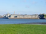 |
| Clarence Store, Royal William Victualling Yard | Stonehouse, Plymouth | Naval Storehouse | 1829–1831 | 13 August 1999 | SX4597153460 50°21′39″N 4°10′01″W / 50.360839°N 4.166865°W / 50.360839; -4.166865 (Clarence Store, Royal William Victualling Yard) | 1378527 |  |
| Devonport Column | Devonport, City of Plymouth | Column | 1824 | 25 January 1954 | SX4531654402 50°22′09″N 4°10′35″W / 50.369133°N 4.176454°W / 50.369133; -4.176454 (Devonport Column) | 1322008 |  More images |
| Devonport Guildhall and Attached Walls | Devonport, City of Plymouth | Wall | 1821–1822 | 25 January 1954 | SX4532854385 50°22′08″N 4°10′35″W / 50.368983°N 4.176279°W / 50.368983; -4.176279 (Devonport Guildhall and Attached Walls) | 1322009 | 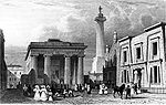 More images |
| Dock Basin Walls and 6 Associated Bollards, Royal William Victualling Yard | Stonehouse, Plymouth | Mooring Bollard | 1826–1832 | 13 August 1999 | SX4612253626 50°21′45″N 4°09′53″W / 50.362371°N 4.164812°W / 50.362371; -4.164812 (Dock Basin Walls and 6 Associated Bollards, Royal William Victualling Yard) | 1378529 |  |
| East Ropery, Formerly Spinning House (S 132), and Attached Retaining Walls | Devonport Dockyard, City of Plymouth | Fireproof Factory | Rebuilt 1813–1817 | 13 August 1999 | SX4518854215 50°22′03″N 4°10′41″W / 50.367419°N 4.178176°W / 50.367419; -4.178176 (East Ropery, Formerly Spinning House (S 132), and Attached Retaining Walls) | 1388400 |  Upload Photo |
| Main Gate, Royal William Victualling Yard | Stonehouse, Plymouth | Gate | 1829–1833 | 13 August 1999 | SX4626053635 50°21′45″N 4°09′46″W / 50.362487°N 4.162877°W / 50.362487; -4.162877 (Main Gate, Royal William Victualling Yard) | 1378530 | 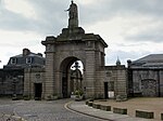 More images |
| Melville, Royal William Victualling Yard | Stonehouse, Plymouth | Fireproof Building | 1828–1832 | 13 August 1999 | SX4616253536 50°21′42″N 4°09′51″W / 50.361572°N 4.164213°W / 50.361572; -4.164213 (Melville, Royal William Victualling Yard) | 1378531 |  |
| Mills and Bakery, Royal William Victualling Yard | Stonehouse, Plymouth | Bakery | 1830–1834 | 13 August 1999 | SX4618553628 50°21′45″N 4°09′50″W / 50.362405°N 4.163928°W / 50.362405; -4.163928 (Mills and Bakery, Royal William Victualling Yard) | 1378532 | 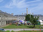 |
| North East Quay Wall and 2 Bollards, Royal William Victualling Yard | Stonehouse, Plymouth | Wall | 1826–1831 | 13 August 1999 | SX4612353659 50°21′46″N 4°09′53″W / 50.362667°N 4.164811°W / 50.362667; -4.164811 (North East Quay Wall and 2 Bollards, Royal William Victualling Yard) | 1378533 | 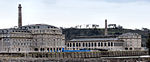 |
| Oddfellows Hall | Devonport, City of Plymouth | Oddfellows Hall | 1823 | 21 January 1954 | SX4538054413 50°22′09″N 4°10′32″W / 50.369248°N 4.17556°W / 50.369248; -4.17556 (Oddfellows Hall) | 1322006 |  More images |
| Old Cooperage, Royal William Victualling Yard | Stonehouse, Plymouth | Ordnance Factory | 1891 | 13 August 1999 | SX4604253476 50°21′40″N 4°09′57″W / 50.361002°N 4.165874°W / 50.361002; -4.165874 (Old Cooperage, Royal William Victualling Yard) | 1378536 |  |
| Plympton House (St Peter's Convent) | Plympton St Maurice | Country House | 1952 | 23 April 1952 | SX5466055896 50°23′06″N 4°02′45″W / 50.384944°N 4.045732°W / 50.384944; -4.045732 (Plympton House (St Peter's Convent)) | 1113363 |  More images |
| Police Buildings, Royal William Victualling Yard | Stonehouse, Plymouth | House | Before 1891 | 13 August 1999 | SX4625653615 50°21′44″N 4°09′47″W / 50.362307°N 4.162925°W / 50.362307; -4.162925 (Police Buildings, Royal William Victualling Yard) | 1378534 |  |
| Prysten House | City of Plymouth | Merchants House | c. 1498 | 25 January 1954 | SX4792354371 50°22′10″N 4°08′23″W / 50.369534°N 4.139811°W / 50.369534; -4.139811 (Prysten House) | 1067152 |  More images |
| Royal Albert Bridge and 17 Approach Spans | Riverside | Suspension Bridge | 1848 | 17 January 1952 | SX4351558740 50°24′28″N 4°12′13″W / 50.40764°N 4.203566°W / 50.40764; -4.203566 (Royal Albert Bridge and 17 Approach Spans) | 1159292 |  More images |
| Saltram House | Saltram Park, City of Plymouth | Country House | 18th century | 23 April 1952 | SX5203855605 50°22′54″N 4°04′57″W / 50.381675°N 4.082474°W / 50.381675; -4.082474 (Saltram House) | 1386230 |  More images |
| Slaughterhouse and Attached Yard Wall, Royal William Victualling Yard | Stonehouse, Plymouth | Wall | 1830–1831 | 13 August 1999 | SX4620853669 50°21′46″N 4°09′49″W / 50.362779°N 4.163621°W / 50.362779; -4.163621 (Slaughterhouse and Attached Yard Wall, Royal William Victualling Yard) | 1378535 | |
| The Quadrangle (n 173-177, 186-191, 203) | Devonport Dockyard, City of Plymouth | Boiler House | 1852–1861 | 13 August 1999 | SX4490255661 50°22′49″N 4°10′58″W / 50.380338°N 4.182791°W / 50.380338; -4.182791 (The Quadrangle (n 173-177, 186-191, 203)) | 1378566 |  |
| Smeaton's Tower | Hoe, City of Plymouth | Lighthouse | 1759 | 25 January 1954 | SX4776253799 50°21′52″N 4°08′31″W / 50.364352°N 4.141841°W / 50.364352; -4.141841 (Smeaton's Tower) | 1386470 |  More images |
| Plymouth Naval War Memorial | The Promenade, Plymouth | War Memorial | 1924 | 1 May 1975 | SX4774053940 50°21′56″N 4°08′32″W / 50.365614°N 4.142208°W / 50.365614; -4.142208 (Plymouth Naval War Memorial) | 1386464 | 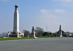 More images |
Notes
- ^ The date given is the date used by Historic England as significant for the initial building or that of an important part in the structure's description.
- ^ Sometimes known as OSGB36, the grid reference is based on the British national grid reference system used by the Ordnance Survey.
- ^ The "List Entry Number" is a unique number assigned to each listed building and scheduled monument by Historic England.
External links
- v
- t
- e
- Bedfordshire
- Berkshire
- Bristol
- Buckinghamshire
- Cambridgeshire
- Cheshire
- Cornwall
- Cumbria
- Derbyshire
- Devon
- Dorset
- Durham
- East Sussex
- East Riding of Yorkshire
- Essex
- Gloucestershire
- Greater London
- Greater Manchester
- Hampshire
- Herefordshire
- Hertfordshire
- Isle of Wight
- Kent
- Lancashire
- Leicestershire
- Lincolnshire
- Merseyside
- Norfolk
- North Yorkshire
- Northamptonshire
- Northumberland
- Nottinghamshire
- Oxfordshire
- Rutland
- Shropshire
- Somerset
- South Yorkshire
- Staffordshire
- Suffolk
- Surrey
- Tyne and Wear
- Warwickshire
- West Midlands
- West Sussex
- West Yorkshire
- Wiltshire
- Worcestershire
- Babergh
- Bath and North East Somerset
- Bradford
- Brighton and Hove
- Broadland
- Cheltenham
- Cheshire East
- Cheshire West and Chester
- Cotswold
- Craven
- Dartford
- Dover
- Forest Heath
- Forest of Dean
- Ipswich
- Maidstone
- Mendip
- Mid Suffolk
- North Somerset
- Sedgemoor
- South Gloucestershire
- South Somerset
- St Edmundsbury
- Stroud
- Suffolk Coastal
- Taunton Deane
- Tewkesbury
- Waveney
- West Somerset
- Churches
- War memorials
- 20th century


