Gschwandt
Place in Upper Austria, Austria

Coat of arms
[1]
(2018-01-01)[2]
4816
Gschwandt is a municipality in the district of Gmunden in the Austrian state of Upper Austria.
Geography
Gschwandt lies in a hilly area with a view on the Traunstein. About 18 percent of the municipality is forest, and 71 percent is farmland.
References
-
 Center of Gschwandt
 -
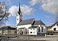 Parish church


- v
- t
- e
Municipalities in the district of Gmunden
Authority control databases | |
|---|---|
| International |
|
| National |
|
 | This Upper Austria location article is a stub. You can help Wikipedia by expanding it. |
- v
- t
- e


