Haddo Peak
Mountain peak in Banff NP, Canada


Haddo Peak
Location of Haddo Peak in Alberta
Show map of Alberta
Haddo Peak
Haddo Peak (Canada)
Show map of CanadaCanadian Rockies
Haddo Peak is a summit in Alberta, Canada.[4] Haddo Peak is located in the Lake Louise area of Banff National Park.
Haddo Peak honors the name of George Gordon, Lord Haddo.[5] Named in 1916, the name became official in 1952.
Geology
Like other mountains in Banff Park, Haddo Peak is composed of sedimentary rock laid down from the Precambrian to Jurassic periods.[6] Formed in shallow seas, this sedimentary rock was pushed east and over the top of younger rock during the Laramide orogeny.[7]
Climate
Based on the Köppen climate classification, Haddo Peak is located in a subarctic climate zone with cold, snowy winters, and mild summers.[8] Winter temperatures can drop below −20 °C (−4 °F) with wind chill factors below −30 °C (−22 °F). Weather conditions during summer months are optimum for climbing.
See also
References
- ^ a b c "Haddo Peak". Bivouac.com. Retrieved 2018-10-14.
- ^ "Topographic map of Haddo Peak". opentopomap.org. Retrieved 2023-07-25.
- ^ "Haddo Peak, Peakvisor.com". Retrieved 2023-03-03.
- ^ a b c "Haddo Peak". Geographical Names Data Base. Natural Resources Canada. Retrieved 2018-10-17.
- ^ Place-names of Alberta. Ottawa: Geographic Board of Canada. 1928. p. 61.
- ^ Belyea, Helen R. (1960). The Story of the Mountains in Banff National Park (PDF). parkscanadahistory.com (Report). Ottawa: Geological Survey of Canada. Archived (PDF) from the original on 2015-10-02. Retrieved 2019-09-13.
- ^ Gadd, Ben (2008). Geology of the Rocky Mountains and Columbias.
- ^ Peel, M. C.; Finlayson, B. L.; McMahon, T. A. (2007). "Updated world map of the Köppen−Geiger climate classification". Hydrol. Earth Syst. Sci. 11: 1633–1644. ISSN 1027-5606.
Gallery
-
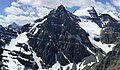 Haddo Peak (centered) seen from summit of Fairview Mountain. Mt. Aberdeen and Mt. Lefroy to right.
 -
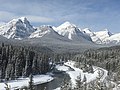
 Haddo and Mount Aberdeen reflected in Lake Herbert
 -
-
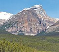 East aspect viewed from Morant's Curve


External links
- Parks Canada web site: Banff National Park


