Haverhill–Bath Covered Bridge
United States historic place
Haverhill–Bath Covered Bridge | |
 The bridge following restoration in 2004 | |
44°9′17″N 72°2′11″W / 44.15472°N 72.03639°W / 44.15472; -72.03639 | |
| Area | 0.1 acres (0.040 ha) |
|---|---|
| Built | 1829 |
| Architectural style | Town lattice truss |
| NRHP reference No. | 77000091[1] |
| Added to NRHP | April 18, 1977 |
The Haverhill–Bath Covered Bridge[a] is a historic covered bridge over the Ammonoosuc River joining Bath and Woodsville, New Hampshire. Formerly used to carry New Hampshire Route 135, the bridge was idled in 1999. Restored in 2004, it is now open to foot traffic only. It is believed to be the oldest covered bridge in the state.[2]
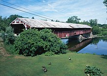
The Haverhill–Bath Bridge is located in the northwestern corner of the town of Haverhill, connecting the village of Woodsville to a rural area in the southwestern corner of Bath. The bridge was built in 1829 with funding provided by both towns. It was built by Moses Abbott and Leonard Walker after Airel Miner, the first choice to supervise the construction, stepped down. The bridge is a Town lattice truss bridge with two spans, resting on stone and concrete abutments, and a stone pier. The road bed is 256 feet 8 inches (78.23 m) long and 14 ft 4 in (4.37 m) wide, and the roof is 277 ft 8 in (84.63 m) long, covering not just the bridge but also framed entrances on both sides. There is a sidewalk (not part of the original construction) on the east (upstream) side of the bridge that is 6 ft 1 in (1.85 m) wide. The roof on that side is extended over the sidewalk, giving the roof profile that of a saltbox house. The downstream side is finished in vertical board siding, with diamond openings spaced along its length and two larger rectangular openings near the ends.[2]
The bridge has survived a number of floods, most notably in 1927, when the lattice work was pierced by a tree trunk, and a barn was carried into the structure.[2] It has been renovated multiple times, most recently in 2004. The bridge was listed on the National Register of Historic Places in 1977.[1] It is commemorated by New Hampshire Historical Marker No. 190.
See also
 New Hampshire portal

- List of bridges documented by the Historic American Engineering Record in New Hampshire
- List of bridges on the National Register of Historic Places in New Hampshire
- List of New Hampshire covered bridges
- National Register of Historic Places listings in Grafton County, New Hampshire
Notes
- ^ Haverhill–Bath per the NRHP nomination;[2] listed as Bath–Haverhill on the state's website.[3]
References
- ^ a b "National Register Information System". National Register of Historic Places. National Park Service. March 13, 2009.
- ^ a b c d "NRHP nomination for Haverhill-Bath Covered Bridge". National Park Service. 1977. Retrieved 2014-04-01.
- ^ "Bridge Name List". New Hampshire Division of Historical Resources. Retrieved July 1, 2020 – via NH.gov.
External links
Wikimedia Commons has media related to Bath-Haverhill Bridge.
- Historic American Engineering Record (HAER) No. NH-33, "Bath-Haverhill Bridge, Spanning Ammonoosuc River, bypassed section of Ammanoosuc Street (SR 135), Woodsville, Grafton County, NH", 18 photos, 3 color transparencies, 4 measured drawings, 26 data pages, 2 photo caption pages
- v
- t
- e
Landmark
- The Epic of American Civilization Murals
- Ashland Gristmill and Dam
- Canaan Street Historic District
- Central Square Historic District
- Colburn Park Historic District
- Dorchester Common Historic District
- Enfield Shaker Historic District
- Enfield Village Historic District
- Haverhill Corner Historic District
- Hebron Village Historic District
- Lyme Center Historic District
- Lyme Common Historic District
- Orford Street Historic District
- Plymouth Historic District
- Shepard Hill Historic District
- True Farm
- Webster Estate
- Abbie Greenleaf Library
- Ashland Junior High School
- Ashland Railroad Station
- Bath Covered Bridge
- Bedell Covered Bridge‡
- Boulderwood
- Brick Store
- Bristol Town Hall
- Burleigh Brae and Webster Boathouse
- Burt–Cheney Farm
- Camp Carnes
- Camp Mowglis
- Camp Ossipee
- Canaan Meetinghouse
- Centre Village Meeting House
- Chapel of the Holy Cross
- Chocorua Island Chapel
- Daniel Carr House
- Dorchester Community Church
- Dow Academy
- Edward H. Lane House
- Enfield Center Town House
- Felsengarten
- First Free Will Baptist Church and Vestry
- Frost Place
- Goodall-Woods Law Office
- Great Hollow Road Stone Arch Bridge
- Hanover Town Library
- Haverhill–Bath Covered Bridge
- Hewitt House
- Holderness Free Library
- Holderness Inn
- Jeremiah Hutchins Tavern
- Lisbon Inn
- Littleton Town Building
- Lovett's by Lafayette Brook
- Lyme–East Thetford Bridge‡
- Minot–Sleeper Library
- Morey Memorial Bridge‡
- Moses Kent House
- Norman and Marion Perry House
- North Holderness Freewill Baptist Church–Holderness Historical Society Building
- Old Grafton County Courthouse
- Owls Head
- Piermont Bridge‡
- The Rocks
- Rockywold–Deephaven Camps
- Sawyer–Medlicott House
- Sphinx Tomb
- Spring Hill Farm
- St. Mark's Episcopal Church
- Stone Arch Underpass
- Swiftwater Covered Bridge
- Thayer's Hotel
- Trinity Church
- US Post Office and Courthouse–Littleton Main
- Watch Rock Camp
- Whipple House
- Woodsville Opera Building
‡This historic property also has portions in an adjacent state.
| Authority control databases: Geographic |
|
|---|


