Hilda Peak
Mountain peak in Banff NP, Alberta, Canada


Hilda Peak
Location of Hilda Peak in Alberta
Show map of Alberta
Hilda Peak
Hilda Peak (Canada)
Show map of CanadaHilda Peak is a 3,058-metre (10,033-foot) mountain summit located at the northern extreme of Banff National Park in the Canadian Rockies of Alberta, Canada. The nearest higher peak is Mount Athabasca, 2.0 km (1.2 mi) to the southwest.[1] Hilda Peak is situated south of Sunwapta Pass and can be prominently seen from the Icefields Parkway. The Hilda Glacier lies to the south side of the peak, and the Boundary Glacier lies to the west.
History
The first ascent of the mountain was made in 1938 by E. Brooks, H. Brooks, R. Cross, and W. Marples.[1] The mountain was named Hilda Peak in 1938.[3]
The mountain's name was officially adopted in 1985 when approved by the Geographical Names Board of Canada.[2]
Geology
Like other mountains in Banff Park, Hilda Peak is composed of sedimentary rock laid down from the Precambrian to Jurassic periods.[4] Formed in shallow seas, this sedimentary rock was pushed east and over the top of younger rock during the Laramide orogeny.[5]
Climate
Based on the Köppen climate classification, Hilda Peak is located in a subarctic climate with cold, snowy winters, and mild summers.[6] Winter temperatures can drop below -20 °C with wind chill factors below -30 °C. Precipitation runoff from Hilda Peak drains east into Hilda Creek, thence Nigel Creek, tributaries of the North Saskatchewan River.
Gallery
-
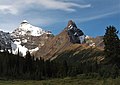
 Hilda (right) with Mt. Athabasca (left)
 -
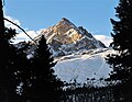 North aspect
 -
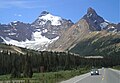 Hilda (right) seen from the Icefields Parkway
 -
 Mt. Athabasca (left) and Hilda Peak (right)
 -
 Hilda Peak (left), Mt. Athabasca (center), Mt. Andromeda (right) from the north
 -
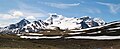
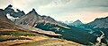 View from Parker Ridge showing Mount Athabasca (left edge), Hilda Peak, Sunwapta Pass and Icefields Parkway.


See also
References
- ^ a b c d e f g "Hilda Peak". Bivouac.com. Retrieved 2019-03-30.
- ^ a b c "Hilda Peak". Geographical Names Data Base. Natural Resources Canada. Retrieved 2019-03-30.
- ^ "Hilda Peak". cdnrockiesdatabases.ca. Retrieved 2019-09-22.
- ^ Belyea, Helen R. (1960). The Story of the Mountains in Banff National Park (PDF). parkscanadahistory.com (Report). Ottawa: Geological Survey of Canada. Archived (PDF) from the original on 2015-10-02. Retrieved 2019-09-13.
- ^ Gadd, Ben (2008). Geology of the Rocky Mountains and Columbias.
- ^ Peel, M. C.; Finlayson, B. L.; McMahon, T. A. (2007). "Updated world map of the Köppen−Geiger climate classification". Hydrol. Earth Syst. Sci. 11: 1633–1644. ISSN 1027-5606.
External links
Wikimedia Commons has media related to Hilda Peak.
- Hilda Peak weather forecast
- Parks Canada web site: Banff National Park
Places adjacent to Hilda Peak | ||||||||||||||||
|---|---|---|---|---|---|---|---|---|---|---|---|---|---|---|---|---|
| ||||||||||||||||


- v
- t
- e
- Ball
- Bare
- Beaverfoot
- Blue
- Bow
- Crowsnest
- Elk
- Fairholme
- Fiddle
- Flathead
- Foothills
- High Rock
- Kananaskis
- Livingstone
- Lizard
- Maligne
- Massive
- Misty
- Morrissey
- Palliser
- President
- Queen Elizabeth
- Rainbow
- Ram
- Sawback
- Sentinel
- Slate
- South Jasper
- Sundance
- Terminal
- Tower of London
- Vermilion
- Victoria Cross
- Waputik
- Winston Churchill
- Continental Ranges
- Hart Ranges
- Muskwa Ranges
- Alberta
- Andromeda
- Assiniboine
- Athabasca
- Brazeau
- Bryce
- Cascade
- Castle
- Castleguard
- Clemenceau
- Columbia
- Cory
- Edith Cavell
- Forbes
- Hector
- Hosmer
- Hungabee
- Joffre
- Kitchener
- Lyell
- Heart
- Pilot
- Pyramid
- Resplendent
- Robson
- Rundle
- Sarbach
- Saskatchewan
- Smythe
- Snow Dome
- Stanley Peak
- Sulphur
- Temple
- Three Sisters
- Trinity
- Twin
- Ulysses
- Unnamed Alberta–BC mountain (formerly Mount Pétain)
- Whymper
see List of rivers of the Canadian Rockies and Category:Rivers of the Canadian Rockies
- Mountain Stoney
- Mountain Metis
| International | |
|---|---|
| National |
|
| Provincial (AB) |
|
| Provincial (BC) |
- See also
- Geography portal
- Canada portal


