Hmangin, Banmauk
24°11′N 95°54′E / 24.183°N 95.900°E / 24.183; 95.900Country  Burma
BurmaRegion Sagaing Region District Katha District Township Banmauk Township Time zone UTC+6.30 (MST)
 Banmauk Township of the Sagaing Region
Settlements 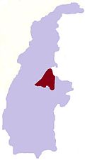
 Burma
BurmaHmangin is a village in Banmauk Township, Katha District, in the Sagaing Region of northern-central Burma.[1]
| Type: | Populated place - a city, town, village, or other agglomeration of buildings where people live and work |
|---|---|
| Mindat.org Region: | Homalin Township, Hkamti District, Sagaing Region, Myanmar |
| Region: | Homalin, Hkamti District, Sagaing Region, Myanmar |
| Latitude: | 24° 42' 11" N |
| Longitude: | 94° 55' 18" E |
| Lat/Long (dec): | 24.70319,94.92172 |
| Köppen climate type: | Cwa : Monsoon-influenced humid subtropical climate |
| Mindat Feature ID: | 1324412 |
| Long-form Identifier: | mindat:2:6:1324412:7 |
| GUID: | 6ba85bae-65fb-44fe-88e6-03cab1fa43a9 |
References
- ^ https://www.google.com/maps/place//@24.183333,95.9,12z/data=!4m2!3m1!1s0x0:0x0!5m1!1e4?hl=en
External links
- Maplandia World Gazetteer
- v
- t
- e
 Banmauk Township of the Sagaing Region
Capital: Banmauk
- Alegan
- Anauktaw
- Banmauk
- Budaung
- Chaungbya
- Chaungzon
- Dayu
- Gaunggaik
- Hawyaw
- Hechein
- Hmangin
- Hmawbon
- Htandaw
- Hteinson
- Htidawgaing
- Hwemaukkan
- Hwesokchi
- Inbauk
- Inbin
- Kalat
- Kandaw
- Kangon
- Kangyi
- Kanni
- Kanthaya
- Kazaukpa
- Kezin
- Khamo
- Khaungton
- Khopyin
- Kyaiktonda
- Kyainggyi
- Kyakat
- Kyauk-aing
- Kyauktan
- Kyaungle
- Kyikazet
- Kyundaw
- Kyungon
- Kywegawgyi
- Legyin
- Leiksaw
- Lemi
- Letpan
- Letpangyin
- Le-u
- Le-u
- Lwegyaung
- Lwin-u
- Magyigon
- Magyigon
- Magyigon
- Magyigon
- Mahaw
- Mangon
- Manhton
- Mankat
- Manna
- Mansein
- Mansi
- Mantun
- Manyu
- Mingon
- Mingon
- Mode
- Mutha
- Mutthein
- Mwe-te
- Nakha
- Namakauk
- Namalut
- Namdaw
- Namhedaung
- Namhkin
- Namkasa
- Nasinkut
- Natmogaung-aleywa
- Natonna
- Naunghmi
- Naungkan
- Naungkut
- Naungkut
- Naunglon
- Naungmalin
- Naungmelon
- Naungmo
- Naungpat
- Nyaungchedauk
- Onhmin
- Pakaw
- Pamon
- Pandaw
- Pandin
- Payindaung
- Pegon
- Pegon
- Peinnebin
- Peta
- Pinbon
- Pinkha
- Pinlon
- Pinmana
- Pula
- Sakhan
- Segyi
- Settaw
- Se-u
- Shwegyaung
- Shwegyaung
- Shwegyaung
- Shwegyin
- Shwehnit
- Simaw
- Sinchidaing
- Sondaw
- Takye
- Tamaing
- Tamakyaing
- Taungchiyin
- Taunggon
- Taungle
- Taunglwe
- Taungyagon
- Tenpadit
- Thangyaw-in
- Thaunggyi
- Thayagon
- Thayagon
- Thayetkon
- Thayetkon
- Thayetkon
- Thinganda
- Tonbok
- Tonbon
- Tongyaung
- Tonkaw
- Tonmun
- Tonpin
- Yeshin
- Ywathitkon

  | This Katha District location article is a stub. You can help Wikipedia by expanding it. |
- v
- t
- e


