Hrádek (Klatovy District)
Municipality in Plzeň, Czech Republic
Flag
Coat of arms
 Czech Republic
 (2024-01-01)[1]
342 01
Hrádek is a municipality and village in Klatovy District in the Plzeň Region of the Czech Republic. It has about 1,400 inhabitants.
Hrádek lies approximately 22 kilometres (14 mi) south-east of Klatovy, 55 km (34 mi) south of Plzeň, and 114 km (71 mi) south-west of Prague.
Administrative parts
The villages of Čejkovy, Čermná, Kašovice, Odolenov, Tedražice and Zbynice are administrative parts of Hrádek.
Demographics
| Year | Pop. | ±% |
|---|---|---|
| 1869 | 2,724 | — |
| 1880 | 2,614 | −4.0% |
| 1890 | 2,772 | +6.0% |
| 1900 | 2,624 | −5.3% |
| 1910 | 2,567 | −2.2% |
| 1921 | 2,556 | −0.4% |
| 1930 | 2,468 | −3.4% |
| 1950 | 1,906 | −22.8% |
| 1961 | 1,901 | −0.3% |
| 1970 | 1,678 | −11.7% |
| 1980 | 1,451 | −13.5% |
| 1991 | 1,331 | −8.3% |
| 2001 | 1,327 | −0.3% |
| 2011 | 1,360 | +2.5% |
| 2021 | 1,307 | −3.9% |
| Source: Censuses[2][3] | ||
Gallery
-
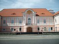 Hrádek Castle
 -
 Area in front of the castle
 -
 Church of Saint Lawrence


References
- ^ "Population of Municipalities – 1 January 2024". Czech Statistical Office. 2024-05-17.
- ^ "Historický lexikon obcí České republiky 1869–2011 – Okres Klatovy" (in Czech). Czech Statistical Office. 2015-12-21. pp. 9–10.
- ^ "Population Census 2021: Population by sex". Public Database. Czech Statistical Office. 2021-03-27.
External links
Wikimedia Commons has media related to Hrádek (Klatovy District).
- Official website
- v
- t
- e
- Běhařov
- Běšiny
- Bezděkov
- Biřkov
- Bolešiny
- Břežany
- Budětice
- Bukovník
- Čachrov
- Černíkov
- Červené Poříčí
- Chanovice
- Chlistov
- Chudenice
- Chudenín
- Číhaň
- Čímice
- Dešenice
- Dlažov
- Dlouhá Ves
- Dobršín
- Dolany
- Domoraz
- Dražovice
- Frymburk
- Hamry
- Hartmanice
- Hejná
- Hlavňovice
- Hnačov
- Horažďovice
- Horská Kvilda
- Hrádek
- Hradešice
- Janovice nad Úhlavou
- Javor
- Ježovy
- Kašperské Hory
- Kejnice
- Klatovy
- Klenová
- Kolinec
- Kovčín
- Křenice
- Kvášňovice
- Lomec
- Malý Bor
- Maňovice
- Měčín
- Mezihoří
- Mlýnské Struhadlo
- Mochtín
- Modrava
- Mokrosuky
- Myslív
- Myslovice
- Nalžovské Hory
- Nehodiv
- Nezamyslice
- Nezdice na Šumavě
- Nýrsko
- Obytce
- Olšany
- Ostřetice
- Pačejov
- Petrovice u Sušice
- Plánice
- Podmokly
- Poleň
- Prášily
- Předslav
- Rabí
- Rejštejn
- Slatina
- Soběšice
- Srní
- Strašín
- Strážov
- Sušice
- Svéradice
- Švihov
- Tužice
- Týnec
- Újezd u Plánice
- Velhartice
- Velké Hydčice
- Velký Bor
- Vřeskovice
- Vrhaveč
- Zavlekov
- Zborovy
- Železná Ruda
- Žichovice
- Žihobce
Authority control databases | |
|---|---|
| International |
|
| National |
|
 | This Plzeň Region location article is a stub. You can help Wikipedia by expanding it. |
- v
- t
- e


