Transportation corridor encircling the city of Chennai
 2 |
|---|
 |
| Route information |
|---|
| Length | 25.2 km (15.7 mi) |
|---|
| Major junctions |
|---|
| North end | SH 104 in Manali |
|---|
| Major intersections | NH 5 in Madhavaram
NH 205 at Padi Junction
SH 112 in Thirumangalam
NH 4 at Koyambedu Junction
SH 113 in Vadapalani
NH 32 at Kathipara Junction |
|---|
| South end | SH 49A in Thiruvanmiyur |
|---|
| |
|---|
| Location |
|---|
| Country | India |
|---|
| |
|---|
| Highway system |
|---|
| |
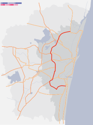
The Inner Ring Road (IRR), also known as Jawaharlal Nehru Salai or 100-Feet road or State Highway 2, is a major transportation corridor encircling the city of Chennai. It was developed by the Chennai Metropolitan Development Authority (CMDA). It is 25.2 km long with three distinct arms viz., Northern arm, Central arm and Southern arm, connecting SH 49A (Rajiv Gandhi Salai) in Tiruvanmiyur, Velachery main road at Vijayanagar, NH 32 (GST road) at Kathipara, NH 4 at Koyambedu, NH 205 at Padi, NH 5 at Madhavaram and joining SH 104 (TPP Road) at Manali.[1]
Details of the corridor
The IRR is a 6-lane road with three arms. The northern arm of IRR starts from Padi Junction and joins SH 104 (TPP) near Manali. It connects NH5 at Madhavaram Junction. The central arm extends from Kathipara Junction and ends at Padi Junction. It connects NH 32 at Kathipara Junction, NH4 at Koyambedu Junction and NH 205 at Padi Junction. The northern and central arms together form State Highway 2. The southern arm of IRR extends from IT corridor in the form of Taramani Link Road and joins NH 32 at Officers Training Academy before ending at Kathipara Junction.[2] The Chennai RBTW is being planned along the Taramani Link Road.
See also
 India portal
References
Wikimedia Commons has media related to Inner Ring Road, Chennai.
- ^ "Waiting for completion of work on Inner Ring Road". The Hindu. 10 July 2006. Archived from the original on 15 July 2006.
- ^ R. Srikanth (15 May 2008). "Inner Ring Road southern extension taking shape". The Hindu. Archived from the original on 22 May 2008.
|
|---|
| Early history (pre-1500) | |
|---|
| Colonial period (1500–1900) | |
|---|
| Modern period (1900–present) | |
|---|
| Writers and historians | |
|---|
|
|
|
|---|
| Regions | |
|---|
| Waterways | |
|---|
| Lakes | |
|---|
| Islands | |
|---|
| Zoological parks | |
|---|
| Reserve Forests | |
|---|
| Marshlands | |
|---|
Heritage
monuments | |
|---|
| Statues | |
|---|
| Memorials | |
|---|
|
|
|
|---|
| Districts | |
|---|
| Taluks | |
|---|
| Constituencies | | Parliamentary | - Chennai Central
- Chennai North
- Chennai South
- Sriperumbudur
- Thiruvallur
|
|---|
| Assembly | - Alandur
- Ambattur
- Anna Nagar
- Avadi
- Chengalpattu
- Chepauk
- Egmore
- Harbour
- Kolathur
- Madhavaram
- Maduravoyal
- Mylapore
- Pallavaram
- Perambur
- Ponneri
- Poonamallee
- RK Nagar
- Royapuram
- Saidapet
- Sholinganallur
- Sriperumbudur
- T.Nagar
- Tambaram
- Thiru. Vi. Ka. Nagar
- Thiruvottiyur
- Thousand Lights
- Tiruvallur
- Villivakkam
- Virugambakkam
- Velachery
|
|---|
|
|---|
| Nodal agencies | |
|---|
|
|
|
|---|
Business
districts | |
|---|
| SEZ | |
|---|
Companies and
institutions | |
|---|
| Industry | |
|---|
|
|
|
|
|
|---|
| Air | |
|---|
| Sea | |
|---|
| Rail | |
|---|
| Road | Roads and
expressways | |
|---|
Grade separators
and flyovers | |
|---|
| Others | |
|---|
|
|---|
|
|
|
|---|
| Venues | |
|---|
| Teams | | Badminton | |
|---|
| Cricket | |
|---|
| Field hockey | |
|---|
| Football | |
|---|
| Kabaddi | |
|---|
| Tennis | |
|---|
| Table tennis | |
|---|
| Volleyball | |
|---|
|
|---|
| Others | |
|---|
|
|
|
|
 Category Category- India portal
 WikiProject WikiProject
|
|
|---|
| Transport by cities | |
|---|
| Air and space | | International airports | |
|---|
| Customs airports | |
|---|
| Domestic airports | |
|---|
| Military bases | |
|---|
| Spaceport | |
|---|
|
|---|
| Rail | | Rail networks | |
|---|
| Major stations | |
|---|
|
|---|
| Road | | National Highways | |
|---|
| State Highways | - SH 4
- SH 6
- SH 9
- SH 10
- SH 15
- SH 22
- SH 49
- SH 49A
- SH 58
- SH 68
- SH 81
- SH 134
- SH 156
|
|---|
| Major roads | |
|---|
| Public transport | |
|---|
|
|---|
| Water | |
|---|


