Kuje
Local government area in Federal Capital Territory, Nigeria
8°52′56″N 7°13′13″E / 8.88222°N 7.22028°E / 8.88222; 7.22028 Nigeria
 (2022 est)[1]

Kuje is a local government area in the Federal Capital Territory in Nigeria.[2]
It has an area of 1,644 km2 and a population of 97,367 at the ct 2006 census.
The postal code of the area is 905.[3]
Attractions
Kuje is a busy market city with a range of roadside stores selling pharmaceuticals, provisions, building materials, ironmongery, tools, phone cards, music CDs. It is also home to several "independent" petrol stations.
Education
Kuje has several state and private schools including Government Secondary School, Kuje Science Primary School, the Capital Science Academy, DFGS Glorious Shining Star Academy and Nigeria-Ghana International College, Kingdom Heritage Model School, Glory and Praise Schools, New Hope Academy, Creative Brains Academy, Astute Monttesorri schools and Aflon Digital Academy. It is also home to a few tertiary institutions like Prime University, Philomath University, Illa College of Health Sciences and Technology among others.
Market
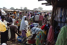


In the centre of Kuje is a colourful market held every 4 days with stalls selling fruit, vegetables, very fresh meat, other provisions, household goods, fabric, shoes, clothing, smoked fish and posters displaying European footballers pictured alongside their houses, wives and cars.[4] Farming is another important economic activity. The region grows crops such maize, potatoes, onions, and groundnuts. Making crafts and working with wood are two more significant economic activity that Kuje LGA citizens engage in. In addition, Kuje LGA is home to several government buildings, motels, and banks.[5]
Expansion
Kuje is seeing a rapid expansion in residential building because of its proximity to Abuja and because of the removal of informal settlements along the airport road.[citation needed] There is a network of well tarred roads serving zones of as yet unbuilt housing whilst the existing residential areas are linked by often impassable, potholed dirt roads.
Geography

Kuje LGA has an average temperature of 30 degrees Celsius and a total area of 1,644 square kilometers. The dry and rainy seasons are the two distinct seasons that the LGA encounters. In Kuje LGA, the annual precipitation total is estimated to be 1250 mm, with an average humidity of 41%.[5]
Climate

The two main seasons in Kuje are the hot summer (June to October), with average highs below 84°F, and the chilly winter (October to December), with lows below 63°F.[6][7][8]
Average Temperature


The average daily maximum temperature during the 2.6-month hot season, which runs from January 27 to April 14, is above 92°F. March is the hottest month in Kuje with an average high temperature of 94°F and low temperature of 73°F. The average daily maximum temperature during the 3.4-month cool season, which runs from June 23 to October 4, is below 84°F. December is the coldest month in Kuje with an average high temperature of 89°F and low temperature of 63°F.[6]
References
- ^ "Federal Capital Territory : Subdivision". www.citypopulation.de. Retrieved 2024-02-05.
- ^ "Kuje District Guide | Land & Houses". Villa Afrika Realty. Retrieved 2019-03-31.
- ^ "Post Offices- with map of LGA". NIPOST. Archived from the original on 2012-11-26. Retrieved 2009-10-20.
- ^ "List of 2 Bedroom Joint Venture Flats in Cloud 9 Estate, Kuje, Abuja". nigeriapropertycentre.com. Retrieved 2021-05-18.
- ^ a b "Kuje Local Government Area". www.manpower.com.ng. Retrieved 2024-08-25.
- ^ a b "Kuje Climate, Weather By Month, Average Temperature (Nigeria) - Weather Spark". weatherspark.com. Retrieved 2023-09-10.
- ^ "Kuje climate: Temperature Kuje & Weather By Month". en.climate-data.org. Retrieved 2023-09-10.
- ^ Atlas, Weather. "Yearly & Monthly weather - Kuje, Nigeria". Weather Atlas. Retrieved 2023-09-10.
External links
Wikimedia Commons has media related to Kuje.
- Official Website
- v
- t
- e
Federal Capital TerritoryCapital: Abuja
- Abaji
- Abuja
- Bwari
- Gwagwalada
- Kuje
- Kwali


