La Couronne, Bouches-du-Rhône
Village in France

La Couronne is a village in the south of France on the Côte Bleue on the Mediterranean coast, notable for its ancient quarries and lighthouses.
Description
La Couronne, formerly known as Queyroun,[1] is a village in the commune of Martigues in the Bouches-du-Rhône département in the south of France. It is situated on the Côte Bleue on the Mediterranean coast. Primarily a bathing resort, on the small coastal railway line connecting Martigues and Marseille, it is also known for the ancient quarries and lighthouses on nearby Cap Couronne.
Cap Couronne was well known to seafarers in antiquity as the most extreme promontory between the Bay of Marseille and the Bay of Fos-sur-Mer. The first staffed square lighthouse, 11.6 m high, was constructed in 1867 and dismantled in 1963, following the construction of an automated circular lighthouse, 33 m high, in 1959.
The stone quarries were already mentioned by the Greek historian Strabo; their remains can now be seen on the shoreline, due to rises in the sea level. Archaeological excavations of an Iron Age village suggest that quarrying began in the sixth century BC. The molasse stone was used in Hellenistic Massalia for both the quays and the ramparts.[2]
Gallery
-
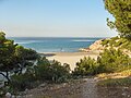
 The beach of Le Verdon
 -
 Overview of the beach of Le Verdon
 -
 Overview of the beach of Le Verdon from the village
 -
 Beach of Verdon on the west
 -
 Beach of La Saulce
 -
 Beach of Sainte-Croix
 -
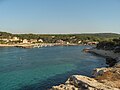 Tamaris harbour


Notes
References
- Provence, Guide Vert, Michelin (1998) ISBN 2-06-137503-0
- James Bromwich, The Roman Remains of Southern France: A Guidebook, Routledge (1993) ISBN 0-415-00837-9
- Albert Dauzat, La toponymie francaise (1939).
- Fabienne Gateau and Michel Provost, Carte archéologique de la Gaule 13/1. Étang de Berre, Editions MSH (1996) ISBN 2-87754-041-3
External links
- Base Mérimée: Phare de Cap Couronne, Ministère français de la Culture. (in French)
- Photos of the beach at le Verdon
- The Côte Bleue Marine Reservation
- The railway station at La Couronne
- Diving on the Côte Bleue
43°20′11″N 5°3′8″E / 43.33639°N 5.05222°E / 43.33639; 5.05222


