List of Category A listed buildings in Orkney

Map all coordinates using OpenStreetMap
Download coordinates as:
- KML
- GPX (all coordinates)
- GPX (primary coordinates)
- GPX (secondary coordinates)
This is a list of Category A listed buildings in the Orkney council area in central Scotland.
In Scotland, the term listed building refers to a building or other structure officially designated as being of "special architectural or historic interest".[1] Category A structures are those considered to be buildings of "national or international importance, either architecturally or historically".[1] Listing was begun by a provision in the Town and Country Planning (Scotland) Act 1947, and the current legislative basis for listing is the Planning (Listed Buildings and Conservation Areas) (Scotland) Act 1997.[1] The authority for listing rests with Historic Environment Scotland, an executive agency of the Scottish Government, which inherited this role from the Scottish Development Department in 1991. Once listed, severe restrictions are imposed on the modifications allowed to a building's structure or its fittings. Listed building consent must be obtained from local authorities prior to any alteration to such a structure. There are approximately 47,000 listed buildings in Scotland, of which around 8 percent (some 3,800) are Category A.[1]
The council area of Orkney comprises an archipelago of around 70 islands, including 20 inhabited islands with a total population of around 20,000. There are 20 Category A listed buildings on the islands.
Listed buildings
| Name | Location | Date Listed | Grid Ref. [note 1] | Geo-coordinates | Notes | LB Number [note 2] | Image |
|---|---|---|---|---|---|---|---|
| Dennis Head Old Beacon, including remains of Keepers' Houses | North Ronaldsay | 8/12/1971 | HY7901255392 | 59°23′03″N 2°22′16″W / 59.384257°N 2.371185°W / 59.384257; -2.371185 (Dennis Head Old Beacon, including remains of Keepers' Houses) | 5891 | 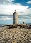 Upload another image | |
| Italian Chapel, including statue | Lamb Holm | 4/6/1987 | HY4876300594 | 58°53′23″N 2°53′27″W / 58.889619°N 2.890695°W / 58.889619; -2.890695 (Italian Chapel, including statue) | 12728 |  Upload another image | |
| Hoy Sound High Lighthouse including Keepers' Houses, Boundary Walls and Gatepiers | Graemsay | 9/12/1977 | HY2680906078 | 58°56′08″N 3°16′24″W / 58.93567°N 3.273316°W / 58.93567; -3.273316 (Hoy Sound High Lighthouse including Keepers' Houses, Boundary Walls and Gatepiers) | 12736 |  Upload another image | |
| Sule Skerry Lighthouse | Sule Skerry | 8/12/1971 | HY6219124420 | 59°06′18″N 2°39′43″W / 59.104967°N 2.661834°W / 59.104967; -2.661834 (Sule Skerry Lighthouse) | 18598 | 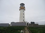 Upload another image | |
| Balfour Castle | Shapinsay | 8/12/1971 | HY4747716435 | 59°01′54″N 2°55′00″W / 59.031704°N 2.916772°W / 59.031704; -2.916772 (Balfour Castle) | 18615 | 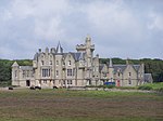 Upload another image | |
| Skaill House | Skara Brae, Mainland | 8/12/1971 | HY2341918614 | 59°02′51″N 3°20′12″W / 59.047625°N 3.336549°W / 59.047625; -3.336549 (Skaill House) | 18704 |  Upload another image | |
| Melsetter House | Hoy | 8/12/1971 | ND2707189360 | 58°47′08″N 3°15′48″W / 58.785614°N 3.263284°W / 58.785614; -3.263284 (Melsetter House) | 18712 |  Upload another image | |
| Rysa Lodge | Hoy | 9/12/1977 | ND3060796227 | 58°50′52″N 3°12′15″W / 58.847855°N 3.204269°W / 58.847855; -3.204269 (Rysa Lodge) | 18714 |  Upload Photo | |
| North Kirk (St Peter's) and Kirkyard | South Ronaldsay | 8/12/1971 | ND4707190844 | 58°48′07″N 2°55′04″W / 58.801864°N 2.917727°W / 58.801864; -2.917727 (North Kirk (St Peter's) and Kirkyard) | 18718 |  Upload another image | |
| Pentland Skerries Lighthouses | Muckle Skerry | 8/12/1971 | ND4649678415 | 58°41′25″N 2°55′29″W / 58.690186°N 2.924709°W / 58.690186; -2.924709 (Pentland Skerries Lighthouses) | 18728 |  Upload another image | |
| Hall of Clestrain | Orphir, Mainland | 8/12/1971 | HY2965807329 | 58°56′51″N 3°13′27″W / 58.94738°N 3.224231°W / 58.94738; -3.224231 (Hall of Clestrain) | 19892 |  Upload another image | |
| Sandwick Kirk (St. Peter's) | Sandwick, Mainland | 9/12/1977 | HY2345419874 | 59°03′32″N 3°20′11″W / 59.058943°N 3.336379°W / 59.058943; -3.336379 (Sandwick Kirk (St. Peter's)) | 19904 |  Upload another image | |
| St Magnus Cathedral | Kirkwall, Broad Street | 8/12/1971 | HY4492110872 | 58°58′53″N 2°57′36″W / 58.981431°N 2.959903°W / 58.981431; -2.959903 (St Magnus Cathedral) | 36668 |  Upload another image | |
| Orkney Museum | Kirkwall, Broad Street | 8/12/1971 | HY4485010869 | 58°58′53″N 2°57′40″W / 58.981395°N 2.961137°W / 58.981395; -2.961137 (Orkney Museum) | 36677 |  Upload another image | |
| Sheep Dyke and associated punds | North Ronaldsay | 16/9/1999 | HY7649954021 | 59°22′19″N 2°24′55″W / 59.371812°N 2.415267°W / 59.371812; -2.415267 (Sheep Dyke and associated punds) | 46400 |  Upload another image | |
| Melsetter House, Chapel | Hoy | 8/12/1971 | ND2703589349 | 58°47′08″N 3°15′50″W / 58.78551°N 3.263903°W / 58.78551; -3.263903 (Melsetter House, Chapel) | 48359 |  Upload another image | |
| Melsetter House, Kitchen Garden including Tea-House and Doocot, Rookery Walls and Gatepiers | Hoy | 8/12/1971 | ND2703689273 | 58°47′05″N 3°15′50″W / 58.784827°N 3.263861°W / 58.784827; -3.263861 (Melsetter House, Kitchen Garden including Tea-House and Doocot, Rookery Walls and Gatepiers) | 48362 | Upload Photo | |
| Scapa Flow Visitor Centre, former Steam Pumping Station and Oil Storage Tank | Hoy | 21/7/2006 | ND3101294647 | 58°50′01″N 3°11′48″W / 58.833734°N 3.196763°W / 58.833734; -3.196763 (Scapa Flow Visitor Centre, former Steam Pumping Station and Oil Storage Tank) | 50533 | 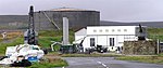 Upload another image | |
| Churchill Barrier No 3 Glimps Holm to Burray[2] | Glimps Holm to Burray | 18/11/2016 | 52392 | ![Churchill Barrier No 3 Glimps Holm to Burray[2]](http://upload.wikimedia.org/wikipedia/commons/thumb/e/eb/Churchill-Barrier-3.jpg/150px-Churchill-Barrier-3.jpg) Upload another image | |||
| Churchill Barrier No 4 Burray to South Ronaldsay[3] | Burray to South Ronaldsay | 18/11/2016 | 52417 | ![Churchill Barrier No 4 Burray to South Ronaldsay[3]](http://upload.wikimedia.org/wikipedia/commons/thumb/5/5b/Churchill-Barrier-4.jpg/150px-Churchill-Barrier-4.jpg) Upload another image |
See also
Notes
- ^ Sometimes known as OSGB36, the grid reference (where provided) is based on the British national grid reference system used by the Ordnance Survey.
• "Guide to National Grid". Ordnance Survey. Retrieved 12 December 2007.
• "Get-a-map". Ordnance Survey. Retrieved 17 December 2007. - ^ Historic Environment Scotland assign a unique alphanumeric identifier to each designated site in Scotland, for listed buildings this always begins with "LB", for example "LB12345".
References
- ^ a b c d Scotland's Listed Buildings 2016. Historic Environment Scotland. 2016. Retrieved 20 February 2017.
- ^ "Churchill Barrier No 3, Glimps Holm to Burray, excluding concrete edge beam, crash barriers, and modern road surfacing, Orkney Islands". Historic Environment Scotland. Retrieved 29 November 2016.
- ^ "Churchill Barrier No 4, Burray to South Ronaldsay, excluding concrete edge beam, crash barriers, modern road surfacing, car parking area and toilet block to northeast, Orkney Islands Islands". Historic Environment Scotland. Retrieved 29 November 2016.
External links
![]() Media related to Category A listed buildings in the Orkney Islands at Wikimedia Commons
Media related to Category A listed buildings in the Orkney Islands at Wikimedia Commons
- v
- t
- e
- City of Aberdeen
- Aberdeenshire
- Angus
- Argyll and Bute
- Clackmannanshire
- Dumfries and Galloway
- City of Dundee
- East Ayrshire
- East Dunbartonshire
- East Lothian
- East Renfrewshire
- City of Edinburgh
- Falkirk
- Fife
- City of Glasgow
- Highland
- Inverclyde
- Midlothian
- Moray
- North Ayrshire
- North Lanarkshire
- Orkney
- Perth and Kinross
- Renfrewshire
- Scottish Borders
- Shetland
- South Ayrshire
- South Lanarkshire
- Stirling
- West Dunbartonshire
- West Lothian
- Western Isles (na h-Eileanan Siar)


