List of Grade I listed buildings in Salisbury
There are 38 buildings and structures listed as Grade I by Historic England in the city of Salisbury, Wiltshire, England.
Twenty-one are within the Cathedral Close. Elsewhere there are:
- 3 churches
- 2 residences
- 2 inns
- 6 buildings that had an institutional or community use when constructed
- 3 river bridges
- an ancient ruin.
| Name | Location | Type | Completed [note 1] | Date designated | Grid ref.[note 2] Geo-coordinates | Entry number [note 3] | Image |
|---|---|---|---|---|---|---|---|
| Myles Place, 68 The Close | The Close, Salisbury | Clergy House | 16th century | 28 February 1952 | SU1411529412 51°03′50″N 1°48′00″W / 51.063873°N 1.79995°W / 51.063873; -1.79995 (Myles Place, 68 The Close) | 1261304 |  More images |
| 91 Crane Street | Crane Street, Salisbury | House | 15th century | 28 February 1952 | SU1422529797 51°04′02″N 1°47′54″W / 51.067332°N 1.798365°W / 51.067332; -1.798365 (91 Crane Street) | 1355821 |  More images |
| Ayleswade Bridge (Old Harnham Bridge) | Aylswade Road, Salisbury | Bridge | 1244 | 28 February 1952 | SU1436229096 51°03′40″N 1°47′47″W / 51.061025°N 1.796438°W / 51.061025; -1.796438 (Ayleswade Bridge (Old Harnham Bridge)) | 1273133 |  More images |
| Bishop's Gate | Exeter Street, Salisbury | House | C14-C15 | 28 February 1952 | SU1451729429 51°03′50″N 1°47′39″W / 51.064016°N 1.794213°W / 51.064016; -1.794213 (Bishop's Gate) | 1355830 |  More images |
| Braybrooke House | The Close, Salisbury | House | C13/C14 | 28 February 1952 | SU1413529697 51°03′59″N 1°47′59″W / 51.066435°N 1.799654°W / 51.066435; -1.799654 (Braybrooke House) | 1023622 |  More images |
| Cathedral Church of St Mary | The Close, Salisbury | Cathedral | 1270–1279 | 28 February 1952 | SU1430029478 51°03′52″N 1°47′50″W / 51.064462°N 1.797307°W / 51.064462; -1.797307 (Cathedral Church of St Mary) | 1023581 |  More images |
| Salisbury Cathedral School | The Close, Salisbury | Bishops Palace | Early 13th century | 28 February 1952 | SU1438529398 51°03′49″N 1°47′46″W / 51.06374°N 1.796098°W / 51.06374; -1.796098 (Salisbury Cathedral School) | 1251561 | 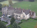 More images |
| Church House incorporating Audley House | Crane Street, Salisbury | House | C15-C16 | 28 February 1952 | SU1416229803 51°04′03″N 1°47′57″W / 51.067387°N 1.799264°W / 51.067387; -1.799264 (Church House incorporating Audley House) | 1023638 |  More images |
| Church of St Lawrence | Stratford-sub-Castle | Church | Early 13th century | 12 October 1972 | SU1303032620 51°05′34″N 1°48′55″W / 51.092745°N 1.815319°W / 51.092745; -1.815319 (Church of St Lawrence) | 1272953 |  More images |
| Church of St Martin | St Martin's Church Street, Salisbury | Church | 13th century | 28 February 1952 | SU1502629597 51°03′56″N 1°47′13″W / 51.065513°N 1.786942°W / 51.065513; -1.786942 (Church of St Martin) | 1259041 | 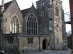 More images |
| Church of St Thomas | St Thomas's Square, Salisbury | Parish Church | founded 1220 | 28 February 1952 | SU1433229985 51°04′08″N 1°47′49″W / 51.06902°N 1.796831°W / 51.06902; -1.796831 (Church of St Thomas) | 1273123 |  More images |
| The King's House | The Close, Salisbury | House | C13/C14 | 28 February 1952 | SU1410129455 51°03′51″N 1°48′01″W / 51.06426°N 1.800148°W / 51.06426; -1.800148 (The King's House) | 1355814 | 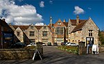 More images |
| Crane Bridge | Crane Bridge Road, Salisbury | Bridge | 15th century | 28 February 1952 | SU1414829835 51°04′04″N 1°47′58″W / 51.067676°N 1.799463°W / 51.067676; -1.799463 (Crane Bridge) | 1240793 |  More images |
| Forecourt Walls, Gate Piers and Gates of Nos 39 to 46 | The Close, Salisbury | Gate | 12 October 1972 | SU1426829724 51°04′00″N 1°47′52″W / 51.066674°N 1.797755°W / 51.066674; -1.797755 (Forecourt Walls, Gate Piers and Gates of Nos 39 to 46) | 1253963 |  More images | |
| Hemingsby House | The Close, Salisbury | Clergy House | Early 14th century | 28 February 1952 | SU1416629737 51°04′00″N 1°47′57″W / 51.066794°N 1.79921°W / 51.066794; -1.79921 (Hemingsby House) | 1355811 | 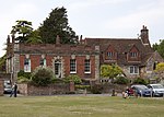 More images |
| John Halle's Hall (Entrance to the Odeon Cinema) | The New Canal, Salisbury | House | 1881 | 28 February 1952 | SU1447229911 51°04′06″N 1°47′41″W / 51.068351°N 1.794836°W / 51.068351; -1.794836 (John Halle's Hall (Entrance to the Odeon Cinema)) | 1258229 |  More images |
| Joiners' Hall | St Ann's Street, Salisbury | Timber Framed House | Early 17th century | 28 February 1952 | SU1480629667 51°03′58″N 1°47′24″W / 51.066148°N 1.790079°W / 51.066148; -1.790079 (Joiners' Hall) | 1258872 |  More images |
| King's Arms | St John's Street, Salisbury | Inn | C15/C16 | 28 February 1952 | SU1457829661 51°03′58″N 1°47′36″W / 51.0661°N 1.793333°W / 51.0661; -1.793333 (King's Arms) | 1273159 |  More images |
| Leaden Hall | The Close, Salisbury | Clergy House | 1717 | 28 February 1952 | SU1411229321 51°03′47″N 1°48′00″W / 51.063054°N 1.799996°W / 51.063054; -1.799996 (Leaden Hall) | 1355816 |  More images |
| Malmesbury House | The Close, Salisbury | House | 1416 | 28 February 1952 | SU1454529642 51°03′57″N 1°47′38″W / 51.06593°N 1.793805°W / 51.06593; -1.793805 (Malmesbury House) | 1252102 |  More images |
| Milford Mill Bridge | Milford Mill Road and Laverstock | Bridge | Late C15/early 16th century | 28 February 1952 | SU1575929764 51°04′01″N 1°46′35″W / 51.066995°N 1.776475°W / 51.066995; -1.776475 (Milford Mill Bridge) | 1242884 |  More images |
| Mill House and Old Mill | West Harnham, Salisbury | Mill House | Early 19th century | 28 February 1952 | SU1353429413 51°03′50″N 1°48′30″W / 51.063896°N 1.808241°W / 51.063896; -1.808241 (Mill House and Old Mill) | 1272956 | 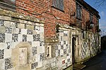 More images |
| Mompesson House | The Close, Salisbury | House | 1704 | 28 February 1952 | SU1422829731 51°04′00″N 1°47′54″W / 51.066738°N 1.798325°W / 51.066738; -1.798325 (Mompesson House) | 1355808 | 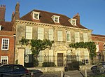 More images |
| North Gate | High Street, Salisbury | Gate | Modern | 28 February 1952 | SU1427329754 51°04′01″N 1°47′52″W / 51.066944°N 1.797682°W / 51.066944; -1.797682 (North Gate) | 1023612 |  More images |
| Remains of Old Sarum Castle and Cathedral | Castle Road, Salisbury | Castle | Norman | 12 October 1972 | SU1376532703 51°05′37″N 1°48′17″W / 51.093474°N 1.80482°W / 51.093474; -1.80482 (Remains of Old Sarum Castle and Cathedral) | 1248682 |  More images |
| Retaining Wall, Screen Railings, Piers and Gates to Front Garden of No 68, The Close | The Close, Salisbury | Gate | c. 1720 | 12 October 1972 | SU1414229407 51°03′50″N 1°47′58″W / 51.063827°N 1.799565°W / 51.063827; -1.799565 (Retaining Wall, Screen Railings, Piers and Gates to Front Garden of No 68, The Close) | 1023629 | More images |
| School of Arts Annexe | Crane Street, Salisbury | House | 18th century | 28 February 1952 | SU1451729781 51°04′02″N 1°47′39″W / 51.067181°N 1.794199°W / 51.067181; -1.794199 (School of Arts Annexe) | 1366014 |  More images |
| Screen Wall, Rails, Piers, Gates and Overthrow in front of Mompesson House | The Close, Salisbury | Gate | 12 October 1972 | SU1422329721 51°04′00″N 1°47′54″W / 51.066649°N 1.798397°W / 51.066649; -1.798397 (Screen Wall, Rails, Piers, Gates and Overthrow in front of Mompesson House) | 1253989 | More images | |
| South or Harnham Gate and South Gate House | De Vaux Place, Salisbury | Gate | 14th century | 28 February 1952 | SU1427129247 51°03′45″N 1°47′52″W / 51.062385°N 1.79773°W / 51.062385; -1.79773 (South or Harnham Gate and South Gate House) | 1240556 | 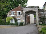 More images |
| St Anne's Gate | St John's Street, Salisbury | Gate | c. 1331 | 28 February 1952 | SU1455029638 51°03′57″N 1°47′37″W / 51.065894°N 1.793733°W / 51.065894; -1.793733 (St Anne's Gate) | 1355835 |  More images |
| The Close Wall | Exeter Street, Salisbury | Wall | 1331 | 28 February 1952 | SU1453929534 51°03′54″N 1°47′38″W / 51.064959°N 1.793895°W / 51.064959; -1.793895 (The Close Wall) | 1251543 |  |
| The Matrons' College | High Street, Salisbury | House | Established 1682 | 28 February 1952 | SU1428029706 51°03′59″N 1°47′51″W / 51.066512°N 1.797584°W / 51.066512; -1.797584 (The Matrons' College) | 1355846 |  More images |
| The Old George Inn | High Street, Salisbury | Timber Framed House | 14th century and later | 28 February 1952 | SU1430329852 51°04′04″N 1°47′50″W / 51.067825°N 1.79725°W / 51.067825; -1.79725 (The Old George Inn) | 1242383 | 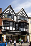 More images |
| The Poultry Cross | Minster Street, Salisbury | Shelter | 14th century | 28 February 1952 | SU1438029956 51°04′08″N 1°47′46″W / 51.068758°N 1.796147°W / 51.068758; -1.796147 (The Poultry Cross) | 1243148 |  More images |
| The Walton Canonry | The Close, Salisbury | House | Earlier house | 28 February 1952 | SU1411829379 51°03′49″N 1°48′00″W / 51.063576°N 1.799909°W / 51.063576; -1.799909 (The Walton Canonry) | 1261267 |  More images |
| Theological College (Sarum College) | The Close, Salisbury | Theological College | Late 17th century | 28 February 1952 | SU1443529670 51°03′58″N 1°47′43″W / 51.066185°N 1.795373°W / 51.066185; -1.795373 (Theological College (Sarum College)) | 1023595 |  More images |
| Trinity Almshouses, Trinity Hospital | Trinity Street, Salisbury | Almshouses | Founded 1379 | 28 February 1952 | SU1466529753 51°04′01″N 1°47′32″W / 51.066925°N 1.792088°W / 51.066925; -1.792088 (Trinity Almshouses, Trinity Hospital) | 1243305 |  More images |
| Wren Hall | The Close, Salisbury | House | Rebuilt 1714 | 28 February 1952 | SU1415929711 51°04′00″N 1°47′58″W / 51.06656°N 1.799311°W / 51.06656; -1.799311 (Wren Hall) | 1023620 |  More images |
See also
Notes
- ^ The date given is the date used by Historic England as significant for the initial building or that of an important part in the structure's description.
- ^ Sometimes known as OSGB36, the grid reference is based on the British national grid reference system used by the Ordnance Survey.
- ^ The "List Entry Number" is a unique number assigned to each listed building and scheduled monument by Historic England.


