List of Indiana state historical markers in Lake County
This is a list of the Indiana state historical markers in Lake County.
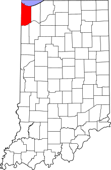
This is intended to be a complete list of the official state historical markers placed in Lake County, Indiana, United States by the Indiana Historical Bureau. The locations of the historical markers and their latitude and longitude coordinates are included below when available, along with their names, years of placement and topics as recorded by the Historical Bureau. There are 14 historical markers located in Lake County.[1]
Map all coordinates using OpenStreetMap
Download coordinates as:
- KML
- GPX (all coordinates)
- GPX (primary coordinates)
- GPX (secondary coordinates)
Historical markers
| Marker title | Image | Year placed | Location | Topics |
|---|---|---|---|---|
| First Physician[2] | 1949 | 2985 West 73rd Place in Merrillville 41°29′6″N 87°22′23″W / 41.48500°N 87.37306°W / 41.48500; -87.37306 (First Physician) | Science, Medicine, and Inventions, Underground Railroad, African American | |
| Great Sauk (Sac) Trail (east–west through this point)[3] | 1966 | Along Van Buren Street at its junction with West 73rd Avenue/Old U.S. Route 30/Lincoln Highway on a traffic median east of Calumet Cemetery and west of Broadway (State Road 53) in Merrillville 41°29′9″N 87°20′46.2″W / 41.48583°N 87.346167°W / 41.48583; -87.346167 (Great Sauk (Sac) Trail (east–west through this point)) | Transportation, American Indian/Native American | |
| St. John's Lutheran Church Tolleston[4] | 1976 | 2235 West 10th Avenue in Gary 41°35′34″N 87°21′57″W / 41.59278°N 87.36583°W / 41.59278; -87.36583 (St. John's Lutheran Church Tolleston) | Religion, Immigration and Ethnic Groups | |
| Dutch in the Calumet Region[5] | 1992 | 8941 Kleinman Road in Highland 41°33′2″N 87°26′14″W / 41.55056°N 87.43722°W / 41.55056; -87.43722 (Dutch in the Calumet Region) | Immigration and Ethnic Groups, Agriculture | |
| St. John Township School, District #2[6] | 1995 | 1515 Joliet Street/Lincoln Highway/U.S. Route 30, east of St. John Road at the St. John Township Community Center in Schererville 41°29′27.6″N 87°29′17.4″W / 41.491000°N 87.488167°W / 41.491000; -87.488167 (St. John Township School, District #2) | Education | |
| The Lincoln Highway – The "Ideal Section"[7] | 1996 | Northeastern corner of the junction of Joliet Street/U.S. Route 30 and Janice Drive in Schererville 41°29′27.6″N 87°28′52.5″W / 41.491000°N 87.481250°W / 41.491000; -87.481250 (The Lincoln Highway The "Ideal Section") | Transportation | |
| Froebel School[8] | 2014 | 15th Avenue and Madison Street in Gary 41°35′16.9″N 87°20′29.9″W / 41.588028°N 87.341639°W / 41.588028; -87.341639 (Forebel School) | Education | |
| Stewart Settlement House[9] | 2014 | 1501 East Massachusetts Street in Gary 41°35′16.0″N 87°20′06.2″W / 41.587778°N 87.335056°W / 41.587778; -87.335056 (Stewart Settlement House) | African American | |
| Rep. Katie Hall (1938-2012), Origin of Dr MLK Day Law[10] |  | 2019 | 1927 Madison St., Gary 41°35′00″N 87°20′29″W / 41.58333°N 87.34139°W / 41.58333; -87.34139 (Rep. Katie Hall Marker) | African American; Politics |
| City Church[11] | 2019 | 577 Washington St., Gary 41°36′01″N 87°20′18″W / 41.60028°N 87.33833°W / 41.60028; -87.33833 (City Church) | Religion, African American, Immigration, Business, Industry and Labor | |
| Mt Zion MB Church[12] | 2019 | 1047 Kenwood St., Hammond 41°35′56″N 87°30′08″W / 41.59889°N 87.50222°W / 41.59889; -87.50222 (Mt Zion MB Church) | Religion, African American | |
| Gary Roosevelt High School[13] | 2020 | 730 W 25th Ave, Gary 41°34′24.3″N 87°20′42.5″W / 41.573417°N 87.345139°W / 41.573417; -87.345139 (Gary Roosevelt High School) | Education, African American | |
| Indiana University Northwest[14] |  | 2021 | Indiana University Northwest, Anderson Library Conference Center, 3400 Broadway, Gary 41°33′20″N 87°20′17″W / 41.55556°N 87.33806°W / 41.55556; -87.33806 (Indiana University Northwest) | Education & Library |
| Hagenbeck-Wallace Circus / 1918 Circus Train Wreck[15] |  | 2022 | Ivanhoe South Nature Preserve, Colfax St., just off US 12/20 near Cline Avenue, Gary 41°35′51.8″N 87°24′48″W / 41.597722°N 87.41333°W / 41.597722; -87.41333 (Hagenbeck-Wallace Circus / 1918 Circus Train Wreck) | Transportation; Arts & Culture |
See also
- List of Indiana state historical markers
- National Register of Historic Places listings in Lake County, Indiana
References
- ^ "Indiana Historical Markers by County". State of Indiana. Retrieved 2012-03-15.
- ^ First Physician, Indiana Historical Bureau, n.d. Accessed 2012-03-14.
- ^ Great Sauk (Sac) Trail (east–west through this point), Indiana Historical Bureau, n.d. Accessed 2012-03-14.
- ^ St. John's Lutheran Church Tolleston, Indiana Historical Bureau, n.d. Accessed 2012-03-14.
- ^ Dutch in the Calumet Region, Indiana Historical Bureau, n.d. Accessed 2012-03-14.
- ^ St. John Township School, District #2, Indiana Historical Bureau, n.d. Accessed 2012-03-14.
- ^ The Lincoln Highway – The "Ideal Section", Indiana Historical Bureau, n.d. Accessed 2012-03-14.
- ^ Froebel School, Indiana Historical Bureau, n.d. Accessed 2016-10-15.
- ^ Stewart Settlement House, Indiana Historical Bureau, n.d. Accessed 2016-10-15.
- ^ IHB (2020-12-16). "Origin of Dr MLK Day Law". IHB. Retrieved 2024-03-18.
- ^ IHB (2020-12-16). "City Church". IHB. Retrieved 2024-03-18.
- ^ IHB (2020-12-16). "Mt Zion MB Church". IHB. Retrieved 2024-03-18.
- ^ IHB (2020-12-16). "Gary Roosevelt High School". IHB. Retrieved 2024-03-18.
- ^ IHB (2022-07-05). "Indiana University Northwest". IHB. Retrieved 2024-03-18.
- ^ IHB (2022-07-06). "Hagenbeck-Wallace Circus / 1918 Circus Train Wreck". IHB. Retrieved 2024-03-18.
External links
- Indiana Historical Marker Program
- Indiana Historical Bureau
- v
- t
- e
Municipalities and communities of Lake County, Indiana, United States
County seat: Crown Point

communities
‡This populated place also has portions in an adjacent county or counties.
- Indiana portal
- United States portal


