List of historic places in Gloucester County, New Brunswick

This article is a list of historic places in Gloucester County, New Brunswick entered on the Canadian Register of Historic Places, whether they are federal, provincial, or municipal.
Map all coordinates using OpenStreetMap
Download coordinates as:
- KML
- GPX (all coordinates)
- GPX (primary coordinates)
- GPX (secondary coordinates)
List of historic places
| Name | Address | Coordinates | Government recognition (CRHP №) | Image | |
|---|---|---|---|---|---|
| Captain Albert House | 26 Des Robins Street Caraquet NB | 47°47′37″N 64°56′02″W / 47.7937°N 64.9339°W / 47.7937; -64.9339 (Captain Albert House) | Caraquet municipality (8013) |  | |
| Albertine Basque House | 502 Georges Street West Tracadie-Sheila NB | 47°30′57″N 64°54′59″W / 47.5158°N 64.9163°W / 47.5158; -64.9163 (Albertine Basque House) | Tracadie-Sheila municipality (5982) |  Upload Photo | |
| Arseneau House | 3459 Albert Street Tracadie-Sheila NB | 47°31′06″N 64°54′50″W / 47.5182°N 64.9139°W / 47.5182; -64.9139 (Arseneau House) | Tracadie-Sheila municipality (6638) | Upload Photo | |
| Rosa Assaff Building | 470 Main Street Bathurst NB | 47°37′06″N 65°38′45″W / 47.6182°N 65.6459°W / 47.6182; -65.6459 (Rosa Assaff Building) | Bathurst municipality (10407) | Upload Photo | |
| Assumption Academy | 1255 Rough Water Drive Bathurst NB | 47°36′35″N 65°37′59″W / 47.6097°N 65.633°W / 47.6097; -65.633 (Assumption Academy) | Bathurst municipality (5237) | Upload Photo | |
| Baldwin House | 393 King Avenue Bathurst NB | 47°37′06″N 65°39′09″W / 47.6183°N 65.6524°W / 47.6183; -65.6524 (Baldwin House) | Bathurst municipality (15125) | Upload Photo | |
| Bathurst Curling Club | 209 St. Andrew Street Bathurst NB | 47°37′06″N 65°39′08″W / 47.6183°N 65.6522°W / 47.6183; -65.6522 (Bathurst Curling Club) | Bathurst municipality (5443) | Upload Photo | |
| Théotime Blanchard House | 279 St-Pierre-Ouest Boulevard Caraquet NB | 47°47′08″N 64°58′25″W / 47.7856°N 64.9737°W / 47.7856; -64.9737 (Théotime Blanchard House) | Caraquet municipality (8000) | 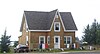 More images | |
| Block Wharf | De La Block Street Tracadie-Sheila NB | 47°31′41″N 64°53′37″W / 47.528°N 64.8935°W / 47.528; -64.8935 (Block Wharf) | Tracadie-Sheila municipality (10500) | Upload Photo | |
| Boîte à Fleurs | 3375 Principale Street Tracadie-Sheila NB | 47°31′22″N 64°54′39″W / 47.5228°N 64.9108°W / 47.5228; -64.9108 (Boîte à Fleurs) | Tracadie-Sheila municipality (5980) |  | |
| Dr. Bourgeois House | 3572 Principale Street Tracadie-Sheila NB | 47°30′50″N 64°54′38″W / 47.5139°N 64.9106°W / 47.5139; -64.9106 (Dr. Bourgeois House) | Tracadie-Sheila municipality (8173) | Upload Photo | |
| Café Royal | 248 J. D. Gauthier Boulevard Shippagan NB | 47°44′37″N 64°42′26″W / 47.7435°N 64.7072°W / 47.7435; -64.7072 (Café Royal) | Shippagan municipality (14745) |  | |
| Caraquet Convent | Saint-Pierre-Ouest Boulevard Caraquet NB | 47°47′24″N 64°57′55″W / 47.7899°N 64.9654°W / 47.7899; -64.9654 (Caraquet Convent) | Caraquet municipality (7946) |  | |
| Causeway Park | Main Street running into Queen Street Bathurst NB | 47°37′13″N 65°39′32″W / 47.6202°N 65.6589°W / 47.6202; -65.6589 (Causeway Park) | Bathurst municipality (12184) | Upload Photo | |
| Château d'Acadie | 3559 Principale Street Tracadie-Sheila NB | 47°30′52″N 64°54′41″W / 47.5144°N 64.9114°W / 47.5144; -64.9114 (Château d'Acadie) | Tracadie-Sheila municipality (7111) |  More images | |
| Collège de Caraquet Site | 220 St-Pierre-Ouest Boulevard Caraquet NB | 47°47′21″N 64°57′52″W / 47.7892°N 64.9645°W / 47.7892; -64.9645 (Collège de Caraquet Site) | Caraquet municipality (8012) |  More images | |
| Corner Store | 4261 Principale Street Tracadie-Sheila NB | 47°28′48″N 64°55′12″W / 47.4801°N 64.9199°W / 47.4801; -64.9199 (Corner Store) | Tracadie-Sheila municipality (7118) | Upload Photo | |
| Daly Point Nature Reserve | 2105 Carron Drive Bathurst NB | 47°38′21″N 65°36′42″W / 47.6392°N 65.6117°W / 47.6392; -65.6117 (Daly Point Nature Reserve) | Bathurst municipality (5437) | Upload Photo | |
| DeGrâce Residence | 111 DeGrace Street Shippagan NB | 47°44′48″N 64°42′44″W / 47.7468°N 64.7121°W / 47.7468; -64.7121 (DeGrâce Residence) | Shippagan municipality (12186) | Upload Photo | |
| Flavien Doucet Residence | 548 King Avenue Bathurst NB | 47°36′58″N 65°39′08″W / 47.6161°N 65.6522°W / 47.6161; -65.6522 (Flavien Doucet Residence) | Bathurst municipality (6705) | Upload Photo | |
| Nazaire Dugas House | 690 St-Pierre-Ouest Boulevard Caraquet NB | 47°46′13″N 65°01′46″W / 47.7703°N 65.0294°W / 47.7703; -65.0294 (Nazaire Dugas House) | Caraquet municipality (8025) | 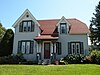 More images | |
| Duguay Residence | 205 J. D. Gauthier Boulevard Shippagan NB | 47°44′41″N 64°42′48″W / 47.7446°N 64.7132°W / 47.7446; -64.7132 (Duguay Residence) | Shippagan municipality (12188) | Upload Photo | |
| Église Saint-Pierre-aux-Liens | 213 St-Pierre Boulevard West Caraquet NB | 47°47′24″N 64°57′51″W / 47.79°N 64.9642°W / 47.79; -64.9642 (Église Saint-Pierre-aux-Liens) | New Brunswick (2147) |  More images | |
| Elhatton's Funeral Home | 187 St. George Street Bathurst NB | 47°37′09″N 65°39′15″W / 47.6193°N 65.6541°W / 47.6193; -65.6541 (Elhatton's Funeral Home) | Bathurst municipality (15121) | Upload Photo | |
| Entreprises Shippagan | 262 J. D. Gauthier Boulevard Shippagan NB | 47°44′36″N 64°42′18″W / 47.7433°N 64.7051°W / 47.7433; -64.7051 (Entreprises Shippagan) | Shippagan municipality (12189) |  | |
| Father Lafrance Monument | Principale Street Tracadie-Sheila NB | 47°30′46″N 64°54′43″W / 47.5129°N 64.912°W / 47.5129; -64.912 (Father Lafrance Monument) | Tracadie-Sheila municipality (6030) | 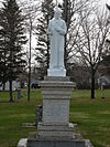 More images | |
| Alcide Ferguson House | 4246 Principal Street Tracadie-Sheila NB | 47°28′52″N 64°55′10″W / 47.4811°N 64.9195°W / 47.4811; -64.9195 (Alcide Ferguson House) | Tracadie-Sheila municipality (8203) | Upload Photo | |
| Former Bank of Montreal Building | 200 Main Street Shippagan NB | 47°37′15″N 65°39′13″W / 47.6209°N 65.6536°W / 47.6209; -65.6536 (Former Bank of Montreal Building) | Shippagan municipality (10408) | Upload Photo | |
| Former École des Mallet | 276 J. D. Gauthier Boulevard Shippagan NB | 47°44′30″N 64°42′13″W / 47.7417°N 64.7036°W / 47.7417; -64.7036 (Former École des Mallet) | Shippagan municipality (12191) |  | |
| Former Foster Mill Site | 994 des Chalets Street Tracadie-Sheila NB | 47°28′22″N 64°55′33″W / 47.4729°N 64.9257°W / 47.4729; -64.9257 (Former Foster Mill Site) | Tracadie-Sheila municipality (6032) | Upload Photo | |
| Former Head Office of the Fédération des Caisses populaires acadiennes | 221 St-Pierre-Ouest Boulevard Caraquet NB | 47°47′22″N 64°57′57″W / 47.7895°N 64.9658°W / 47.7895; -64.9658 (Former Head Office of the Fédération des Caisses populaires acadiennes) | Caraquet municipality (8010) | More images | |
| Founders' Cemetery | Saulnier Est Street Tracadie-Sheila NB | 47°30′30″N 64°54′15″W / 47.5084°N 64.9042°W / 47.5084; -64.9042 (Founders' Cemetery) | Tracadie-Sheila municipality (7131) | Upload Photo | |
| Founding Families Monument | 3585 Principale Street Tracadie-Sheila NB | 47°30′50″N 64°54′41″W / 47.5139°N 64.9113°W / 47.5139; -64.9113 (Founding Families Monument) | Tracadie-Sheila municipality (8172) |  More images | |
| Fransblow Buildings | 3481 and 3485 Albert Street Tracadie-Sheila NB | 47°31′02″N 64°54′47″W / 47.5173°N 64.913°W / 47.5173; -64.913 (Fransblow Buildings) | Tracadie-Sheila municipality (7574) | Upload Photo | |
| Gabriel Giraud Site | Parc des Fondateurs on Saint-Paul Street Bas-Caraquet NB | 47°47′57″N 64°52′38″W / 47.7993°N 64.8773°W / 47.7993; -64.8773 (Gabriel Giraud Site) | New Brunswick (6641) |  More images | |
| Gloucester Hotel | 100 Main Street Bathurst NB | 47°37′12″N 65°39′23″W / 47.62°N 65.6564°W / 47.62; -65.6564 (Gloucester Hotel) | Bathurst municipality (5233) | Upload Photo | |
| Herman J. Good V.C Branch No.18 Royal Canadian Legion War Museum | 575 St. Peter Ave Bathurst NB | 47°37′47″N 65°40′02″W / 47.6297°N 65.6672°W / 47.6297; -65.6672 (Herman J. Good V.C Branch No.18 Royal Canadian Legion War Museum) | Bathurst municipality (5457) | Upload Photo | |
| Greco Restaurant | 211 J.-D.-Gauthier Boulevard Shippagan NB | 47°44′41″N 64°42′45″W / 47.7446°N 64.7124°W / 47.7446; -64.7124 (Greco Restaurant) | Shippagan municipality (12181) | Upload Photo | |
| J. Harper and Gwendolyn Kent Home | 695 Murray Avenue Bathurst NB | 47°36′54″N 65°38′52″W / 47.615°N 65.6478°W / 47.615; -65.6478 (J. Harper and Gwendolyn Kent Home) | Bathurst municipality (9992) | Upload Photo | |
| Heritage Trail | Principale Street Tracadie-Sheila NB | 47°30′40″N 64°54′24″W / 47.5111°N 64.9068°W / 47.5111; -64.9068 (Heritage Trail) | Tracadie-Sheila municipality (9902) | 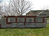 More images | |
| Holy Family Cemetery | 430 St. Peter Avenue Bathurst NB | 47°37′43″N 65°39′48″W / 47.6286°N 65.6633°W / 47.6286; -65.6633 (Holy Family Cemetery) | Bathurst municipality (9695) | Upload Photo | |
| Hotel Dieu Hospital | 645 Murray Ave Bathurst NB | 47°36′55″N 65°38′49″W / 47.6153°N 65.6469°W / 47.6153; -65.6469 (Hotel Dieu Hospital) | Bathurst municipality (5236) | Upload Photo | |
| Hotel Paulin | 143 St-Pierre-Ouest Boulevard Caraquet NB | 47°47′28″N 64°57′14″W / 47.791°N 64.954°W / 47.791; -64.954 (Hotel Paulin) | Caraquet municipality (7926) | 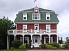 More images | |
| Joseph Kent Farm | 1270 Riverside Dr Bathurst NB | 47°36′33″N 65°40′16″W / 47.6091°N 65.6711°W / 47.6091; -65.6711 (Joseph Kent Farm) | Bathurst municipality (5234) | Upload Photo | |
| Loggie's Buildings | 3494 Dr Victor LeBlanc Blvd., 3497 and 3493 Albert Street Tracadie-Sheila NB | 47°31′01″N 64°54′46″W / 47.517°N 64.9127°W / 47.517; -64.9127 (Loggie's Buildings) | Tracadie-Sheila municipality (8163) | Upload Photo | |
| A & R Loggie's | 3490 Principale Street Tracadie-Sheila NB | 47°31′03″N 64°54′41″W / 47.5176°N 64.9115°W / 47.5176; -64.9115 (A & R Loggie's) | Tracadie-Sheila municipality (7121) | Upload Photo | |
| W. A. Losier House | 3668 Principale Street Tracadie-Sheila NB | 47°30′36″N 64°54′33″W / 47.51°N 64.9093°W / 47.51; -64.9093 (W. A. Losier House) | Tracadie-Sheila municipality (8211) | Upload Photo | |
| Louis Mailloux Monument | Des Patriotes Street Caraquet NB | 47°47′30″N 64°56′41″W / 47.7916°N 64.9447°W / 47.7916; -64.9447 (Louis Mailloux Monument) | Caraquet municipality (8011) | 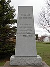 More images | |
| Maison de la fondue | 3613 Luce Street Tracadie-Sheila NB | 47°30′44″N 64°54′39″W / 47.5121°N 64.9108°W / 47.5121; -64.9108 (Maison de la fondue) | Tracadie-Sheila municipality (7112) | Upload Photo | |
| John Meahan House | 666 King Avenue Bathurst NB | 47°36′53″N 65°39′07″W / 47.6147°N 65.6519°W / 47.6147; -65.6519 (John Meahan House) | Bathurst municipality (6707) | Upload Photo | |
| Miscou Island Lighthouse National Historic Site of Canada | Miscou Island NB | 48°00′22″N 64°29′27″W / 48.0061°N 64.4909°W / 48.0061; -64.4909 (Miscou Island Lighthouse National Historic Site of Canada) | Federal (16125, (9728) |  More images | |
| Nepisiguit Centennial Museum/Cultural Centre | 360 Douglas Ave Bathurst NB | 47°37′04″N 65°39′22″W / 47.6179°N 65.656°W / 47.6179; -65.656 (Nepisiguit Centennial Museum/Cultural Centre) | Bathurst municipality (5480) | Upload Photo | |
| Northern Light | 355 King Avenue Bathurst NB | 47°37′07″N 65°39′09″W / 47.6186°N 65.6525°W / 47.6186; -65.6525 (Northern Light) | Bathurst municipality (5460) | Upload Photo | |
| O'Brien House | 324 St. Patrick Street Bathurst NB | 47°37′03″N 65°38′52″W / 47.6174°N 65.6477°W / 47.6174; -65.6477 (O'Brien House) | Bathurst municipality (10421) | Upload Photo | |
| Officers' Mess | 555 Murray Avenue Bathurst NB | 47°37′00″N 65°38′55″W / 47.6166°N 65.6485°W / 47.6166; -65.6485 (Officers' Mess) | Bathurst municipality (10376) | Upload Photo | |
| Old Bathurst Post Office | 96 Main Street Bathurst NB | 47°37′13″N 65°39′26″W / 47.6202°N 65.6571°W / 47.6202; -65.6571 (Old Bathurst Post Office) | New Brunswick (2282) | 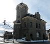 More images | |
| Denis Ouellet House | 4239 Principale Street Tracadie-Sheila NB | 47°28′53″N 64°55′12″W / 47.4813°N 64.92°W / 47.4813; -64.92 (Denis Ouellet House) | Tracadie-Sheila municipality (8194) | Upload Photo | |
| Pallen House | 210-214 King Avenue Bathurst NB | 47°37′14″N 65°39′14″W / 47.6205°N 65.6539°W / 47.6205; -65.6539 (Pallen House) | Bathurst municipality (10604) | Upload Photo | |
| Simonne Paulin House | 1020 Ste-Marie Street Sainte-Marie-Saint-Raphael NB | 47°46′32″N 64°34′43″W / 47.7755°N 64.5787°W / 47.7755; -64.5787 (Simonne Paulin House) | Sainte-Marie-Saint-Raphael municipality (19987) | Upload Photo | |
| Pavillon Irène Léger | 218 J. D. Gauthier Boulevard Shippagan NB | 47°44′46″N 64°42′30″W / 47.746°N 64.7083°W / 47.746; -64.7083 (Pavillon Irène Léger) | Shippagan municipality (12183) | 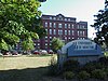 | |
| Petite école | 276 St-Pierre-Ouest Boulevard Caraquet NB | 47°47′09″N 64°58′22″W / 47.7857°N 64.9727°W / 47.7857; -64.9727 (Petite école) | Caraquet municipality (7995) | Upload Photo | |
| Pointe-aux-Pères Site | 150-154 Youghall Drive Bathurst NB | 47°38′51″N 65°39′41″W / 47.6474°N 65.6614°W / 47.6474; -65.6614 (Pointe-aux-Pères Site) | New Brunswick (2668) | Upload Photo | |
| Protestant Cemetery | Principale Street Tracadie-Sheila NB | 47°30′34″N 64°54′32″W / 47.5094°N 64.909°W / 47.5094; -64.909 (Protestant Cemetery) | Tracadie-Sheila municipality (7114) | Upload Photo | |
| Religious Hospitallers of St. Joseph Cemetery | Couvent Street Tracadie-Sheila NB | 47°30′45″N 64°54′30″W / 47.5126°N 64.9082°W / 47.5126; -64.9082 (Religious Hospitallers of St. Joseph Cemetery) | Tracadie-Sheila municipality (5974) |  More images | |
| Clovis T. Richard Home | 262 Main Street Bathurst NB | 47°37′12″N 65°39′06″W / 47.62°N 65.6517°W / 47.62; -65.6517 (Clovis T. Richard Home) | Bathurst municipality (10607) | Upload Photo | |
| Rioux Residence | 223 J. D. Gauthier Boulevard Shippagan NB | 47°44′39″N 64°42′37″W / 47.7443°N 64.7104°W / 47.7443; -64.7104 (Rioux Residence) | Shippagan municipality (12187) | Upload Photo | |
| Edmund Roussel House | 4251 Principale Street Tracadie-Sheila NB | 47°28′51″N 64°55′12″W / 47.4807°N 64.92°W / 47.4807; -64.92 (Edmund Roussel House) | Tracadie-Sheila municipality (8187) | Upload Photo | |
| Sacred Heart Cathedral | 123 St. Andrews Street Bathurst NB | 47°37′04″N 65°39′19″W / 47.6178°N 65.6553°W / 47.6178; -65.6553 (Sacred Heart Cathedral) | Bathurst municipality (5225) |  | |
| Sainte-Anne Chapel | 579 St-Pierre-Ouest Boulevard Caraquet NB | 47°46′25″N 65°00′44″W / 47.7737°N 65.0123°W / 47.7737; -65.0123 (Sainte-Anne Chapel) | Caraquet municipality (8014) | Upload Photo | |
| Sainte-Famille Academy | 399 du Couvent Street Tracadie-Sheila NB | 47°30′46″N 64°54′33″W / 47.5129°N 64.9092°W / 47.5129; -64.9092 (Sainte-Famille Academy) | New Brunswick (6240), Tracadie-Sheila municipality (7113) | 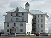 More images | |
| St. George's Anglican Cemetery | 255 Douglas Avenue Bathurst NB | 47°37′10″N 65°39′21″W / 47.6194°N 65.6558°W / 47.6194; -65.6558 (St. George's Anglican Cemetery) | Bathurst municipality (6450) | Upload Photo | |
| St. George's Anglican Church | 432 King Avenue Bathurst NB | 47°37′02″N 65°39′10″W / 47.6172°N 65.6528°W / 47.6172; -65.6528 (St. George's Anglican Church) | Bathurst municipality (5969) | Upload Photo | |
| Saint-Isidore Church | 3915 Fondateurs Blvd. Hautes-Terres NB | 47°33′13″N 65°03′13″W / 47.5535°N 65.0535°W / 47.5535; -65.0535 (Saint-Isidore Church) | New Brunswick (2494) | Upload Photo | |
| Saint John's United Church | 260 J. D. Gauthier Boulevard Shippagan NB | 47°44′35″N 64°42′21″W / 47.743°N 64.7059°W / 47.743; -64.7059 (Saint John's United Church) | Shippagan municipality (12185) |  | |
| St-Joseph et St-Jean-Baptiste Church | 3475. Principale Street Tracadie-Sheila NB | 47°30′48″N 64°54′44″W / 47.5134°N 64.9121°W / 47.5134; -64.9121 (St-Joseph et St-Jean-Baptiste Church) | Tracadie-Sheila municipality (7206) |  More images | |
| St. Joseph Shrine | 3427 de la Chapelle Street Tracadie-Sheila NB | 47°31′17″N 64°54′12″W / 47.5215°N 64.9032°W / 47.5215; -64.9032 (St. Joseph Shrine) | Tracadie-Sheila municipality (7132) |  More images | |
| St. Luke's Cemetery | 390 St. Luke Court Bathurst NB | 47°37′36″N 65°39′56″W / 47.6267°N 65.6656°W / 47.6267; -65.6656 (St. Luke's Cemetery) | Bathurst municipality (10005) | Upload Photo | |
| Sainte-Rose-De-Lima Church | 1981, Route 355 Sainte-Rose NB | 47°37′27″N 64°59′05″W / 47.6241°N 64.9847°W / 47.6241; -64.9847 (Sainte-Rose-De-Lima Church) | New Brunswick (2322) | Upload Photo | |
| Salon de Couture Modifique | 3491 Albert Street Tracadie-Sheila NB | 47°31′02″N 64°54′46″W / 47.5171°N 64.9128°W / 47.5171; -64.9128 (Salon de Couture Modifique) | Tracadie-Sheila municipality (5972) | Upload Photo | |
| Schryer House | 615 Murray Avenue Bathurst NB | 47°36′57″N 65°38′53″W / 47.6158°N 65.6481°W / 47.6158; -65.6481 (Schryer House) | Bathurst municipality (10377) | Upload Photo | |
| Dr. Smith House | 3708 Principale Street Tracadie-Sheila NB | 47°30′30″N 64°54′33″W / 47.5082°N 64.9093°W / 47.5082; -64.9093 (Dr. Smith House) | Tracadie-Sheila municipality (8216) | Upload Photo | |
| Tabagie Centre-ville | 219 J. D. Gauthier Boulevard Shippagan NB | 47°44′40″N 64°42′40″W / 47.7444°N 64.7111°W / 47.7444; -64.7111 (Tabagie Centre-ville) | Shippagan municipality (12182) | Upload Photo | |
| Tower | Entrance to Shippagan Gulley Shippagan NB | 47°43′16″N 64°40′02″W / 47.7211°N 64.6673°W / 47.7211; -64.6673 (Tower (Big Shippagan Light)) | Federal (4741) |  | |
| Village Historique Acadien | Route 11, 14311-2 New Bandon-Salmon Beach NB | 47°47′49″N 65°06′05″W / 47.797°N 65.1014°W / 47.797; -65.1014 (Village Historique Acadien) | New Brunswick (6222) |  | |
| Wade Surplus d'Armée | 4254 Principale Street Tracadie-Sheila NB | 47°28′50″N 64°55′10″W / 47.4805°N 64.9194°W / 47.4805; -64.9194 (Wade Surplus d'Armée) | Tracadie-Sheila municipality (6686) | Upload Photo | |
| Walker Trading Establishment | 1500 Queen Elizabeth Drive Bathurst NB | 47°39′25″N 65°37′22″W / 47.657°N 65.6228°W / 47.657; -65.6228 (Walker Trading Establishment) | New Brunswick (2544) | Upload Photo | |
| Willis Farmhouse | 635 Youghall Drive Bathurst NB | 47°39′13″N 65°39′18″W / 47.6537°N 65.655°W / 47.6537; -65.655 (Willis Farmhouse) | Bathurst municipality (10449) | Upload Photo |
See also
Wikimedia Commons has media related to Cultural heritage monuments in Gloucester County, New Brunswick.


