List of listed buildings in Caddonfoot, Scottish Borders
This is a list of listed buildings in the parish of Caddonfoot in the Scottish Borders, Scotland.
Map all coordinates using OpenStreetMap
Download coordinates as:
- KML
- GPX (all coordinates)
- GPX (primary coordinates)
- GPX (secondary coordinates)
List
| Name | Location | Date Listed | Grid Ref. [note 1] | Geo-coordinates | Notes | LB Number [note 2] | Image |
|---|---|---|---|---|---|---|---|
| Ashiesteel Bridge | 55°36′22″N 2°53′33″W / 55.606039°N 2.892536°W / 55.606039; -2.892536 (Ashiesteel Bridge) | Category A | 1903 |  Upload another image | |||
| Ashiesteel | 55°36′24″N 2°54′21″W / 55.606545°N 2.905707°W / 55.606545; -2.905707 (Ashiesteel) | Category A | 1902 |  Upload Photo | |||
| Torwoodlee | 55°37′57″N 2°50′26″W / 55.632483°N 2.840483°W / 55.632483; -2.840483 (Torwoodlee) | Category A | 135 |  Upload another image | |||
| Peel Hospital | 55°36′13″N 2°54′05″W / 55.603657°N 2.901291°W / 55.603657; -2.901291 (Peel Hospital) | Category A | 1904 |  Upload another image | |||
| Torwoodlee Tower | 55°37′49″N 2°50′53″W / 55.630364°N 2.848125°W / 55.630364; -2.848125 (Torwoodlee Tower) | Category B | 1910 | Upload Photo | |||
| Old Fairnlee | 55°35′21″N 2°51′56″W / 55.589088°N 2.86548°W / 55.589088; -2.86548 (Old Fairnlee) | Category B | 1898 | Upload Photo | |||
| Yair Bridge | 55°35′01″N 2°51′40″W / 55.583602°N 2.861124°W / 55.583602; -2.861124 (Yair Bridge) | Category A | 1901 | 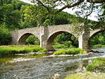 Upload another image | |||
| Elibank House | 55°37′14″N 2°57′39″W / 55.62053°N 2.960764°W / 55.62053; -2.960764 (Elibank House) | Category B | 1906 | Upload Photo | |||
| Clovenfords Hotel | 55°37′07″N 2°52′36″W / 55.618608°N 2.876674°W / 55.618608; -2.876674 (Clovenfords Hotel) | Category B | 1907 | Upload Photo | |||
| Statue Of Sir Walter Scott Bart, Clovenfords | 55°37′06″N 2°52′36″W / 55.618455°N 2.876686°W / 55.618455; -2.876686 (Statue Of Sir Walter Scott Bart, Clovenfords) | Category B | 1908 | Upload Photo | |||
| Caddonfoot Parish Church (Church Of Scotland) Including Graveyard, Boundary Walls, Gatepiers And Gates | 55°36′12″N 2°52′24″W / 55.603355°N 2.873397°W / 55.603355; -2.873397 (Caddonfoot Parish Church (Church Of Scotland) Including Graveyard, Boundary Walls, Gatepiers And Gates) | Category B | 18 | Upload Photo | |||
| Fairnilee | 55°35′21″N 2°51′52″W / 55.589221°N 2.864579°W / 55.589221; -2.864579 (Fairnilee) | Category B | 1897 | Upload Photo | |||
| Yair House | 55°35′10″N 2°52′10″W / 55.586239°N 2.869495°W / 55.586239; -2.869495 (Yair House) | Category A | 1899 |  Upload another image | |||
| Caddonfoot Parish Church, War Memorial | 55°36′12″N 2°52′23″W / 55.60324°N 2.873173°W / 55.60324; -2.873173 (Caddonfoot Parish Church, War Memorial) | Category C(S) | 45778 | Upload Photo | |||
| Elibank Castle | 55°37′00″N 2°57′33″W / 55.616607°N 2.959033°W / 55.616607; -2.959033 (Elibank Castle) | Category B | 1905 | Upload Photo | |||
| Old Post Office, Clovenfords | 55°37′05″N 2°52′38″W / 55.618173°N 2.877204°W / 55.618173; -2.877204 (Old Post Office, Clovenfords) | Category B | 1909 | Upload Photo | |||
| Stables Yair House | 55°35′07″N 2°52′10″W / 55.585287°N 2.869426°W / 55.585287; -2.869426 (Stables Yair House) | Category B | 1900 | Upload Photo |
Key
The scheme for classifying buildings in Scotland is:
- Category A: "buildings of national or international importance, either architectural or historic; or fine, little-altered examples of some particular period, style or building type."[1]
- Category B: "buildings of regional or more than local importance; or major examples of some particular period, style or building type, which may have been altered."[1]
- Category C: "buildings of local importance; lesser examples of any period, style, or building type, as originally constructed or moderately altered; and simple traditional buildings which group well with other listed buildings."[1]
In March 2016 there were 47,288 listed buildings in Scotland. Of these, 8% were Category A, and 50% were Category B, with the remaining 42% being Category C.[2]
Notes
- ^ Sometimes known as OSGB36, the grid reference (where provided) is based on the British national grid reference system used by the Ordnance Survey.
• "Guide to National Grid". Ordnance Survey. Retrieved 12 December 2007.
• "Get-a-map". Ordnance Survey. Retrieved 17 December 2007. - ^ Historic Environment Scotland assign a unique alphanumeric identifier to each designated site in Scotland, for listed buildings this always begins with "LB", for example "LB12345".
References
- All entries, addresses and coordinates are based on data from Historic Scotland. This data falls under the Open Government Licence
- ^ a b c "What is Listing?". Historic Environment Scotland. Retrieved 29 May 2018.
- ^ Scotland's Historic Environment Audit 2016 (PDF). Historic Environment Scotland and the Built Environment Forum Scotland. pp. 15–16. Retrieved 29 May 2018.
- v
- t
- e
- Abbey St Bathans
- Ancrum
- Ashkirk
- Ayton
- Bedrule
- Bowden
- Broughton, Glenholm and Kilbucho
- Bunkle and Preston
- Caddonfoot
- Castleton
- Cavers
- Channelkirk
- Chirnside
- Cockburnspath
- Coldingham
- Coldstream
- Crailing
- Cranshaws
- Drumelzier
- Duns
- Earlston
- Eccles
- Eckford
- Eddleston
- Ednam
- Edrom
- Ettrick
- Eyemouth
- Fala and Soutra
- Fogo
- Foulden
- Galashiels
- Gordon
- Greenlaw
- Hawick
- Heriot
- Hobkirk
- Hownam
- Hume
- Hutton
- Innerleithen
- Jedburgh
- Kelso
- Kirkhope
- Kirkurd
- Ladykirk
- Langton
- Lauder
- Legerwood
- Lilliesleaf
- Linton
- Longformacus
- Lyne
- Makerstoun
- Manor
- Maxton
- Melrose
- Mertoun
- Minto
- Mordington
- Morebattle
- Nenthorn
- Newlands
- Oxnam
- Peebles
- Penicuik
- Polwarth
- Roberton
- Roxburgh
- Selkirk
- Skirling
- Smailholm
- Southdean
- Sprouston
- St Boswells
- Stichill
- Stobo
- Stow
- Swinton
- Teviothead
- Traquair
- Tweedsmuir
- Westruther
- Whitsome
- Yarrow
- Yetholm


