Listed buildings in Sheffield S5
The S5 district lies within the City of Sheffield, South Yorkshire, England. The district contains 18 listed buildings that are recorded in the National Heritage List for England. Of these, one is listed at Grade II*, the middle grade, and the others are at Grade II, the lowest grade. The district is in the north of the city of Sheffield, and includes the areas of Firth Park, Fir Vale, Longley, Parson Cross, Shirecliffe, Shiregreen, Southey Green and Wadsley Bridge.
For neighbouring areas, see listed buildings in S3, listed buildings in S4, listed buildings in S6, listed buildings in S9, listed buildings in S35 and listed buildings in Rotherham (Keppel Ward).
Key
Map all coordinates using OpenStreetMap
Download coordinates as:
- KML
- GPX (all coordinates)
- GPX (primary coordinates)
- GPX (secondary coordinates)
| Grade | Criteria[1] |
|---|---|
| II* | Particularly important buildings of more than special interest |
| II | Buildings of national importance and special interest |
Buildings
| Name and location | Street | Photograph | Date | Notes | Grade |
|---|---|---|---|---|---|
| 2 Hatfield House Court 53°25′27″N 1°27′02″W / 53.42428°N 1.45060°W / 53.42428; -1.45060 (2, HATFIELD HOUSE COURT) | Hatfield House Croft |  | Late 16th century | II | |
| Concord Park Barn 53°25′33″N 1°26′23″W / 53.42584°N 1.43966°W / 53.42584; -1.43966 (BARN AT WEST ENTRANCE TO CONCORD PARK) | Oaks Lane | 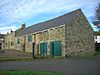 | Early 17th century | II | |
| Abbey Grange Nursing Home 53°24′40″N 1°26′51″W / 53.41105°N 1.44739°W / 53.41105; -1.44739 (ABBEYGRANGE NURSING HOME AND ADJOINING FORMER STABLE ENTRANCE) | Cammel Road |  | Late 18th century | Formerly Page Hall | II |
| 1–7 Hatfield House Croft 53°25′28″N 1°27′01″W / 53.42446°N 1.45029°W / 53.42446; -1.45029 (1-7, HATFIELD HOUSE CROFT) | Hatfield House Croft |  | Late 18th century | II | |
| Longley Hall 53°24′54″N 1°27′40″W / 53.41510°N 1.46119°W / 53.41510; -1.46119 (LONGLEY HALL) | Longley Lane | 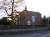 | Late 18th century | II | |
| Goddard Hall 53°24′30″N 1°27′28″W / 53.40834°N 1.45791°W / 53.40834; -1.45791 (GODDARD HALL) | Herries Road |  | Early 19th century | Now part of the Northern General Hospital | II |
| Wincobank Chapel 53°25′02″N 1°26′03″W / 53.41728°N 1.43420°W / 53.41728; -1.43420 (WINCOBANK UNDENOMINATIONAL CHAPEL AND ADJOINING SCHOOLROOM) | Wincobank Avenue |  | 1841 | II | |
| Five Arches 53°24′46″N 1°29′35″W / 53.41264°N 1.49306°W / 53.41264; -1.49306 (RAILWAY VIADUCT) | Herries Road | 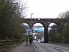 | 1845 | Designed by Joseph Locke | II |
| Firth Park Lodge and Pavilion 53°24′47″N 1°26′40″W / 53.41317°N 1.44447°W / 53.41317; -1.44447 (SHEFFIELD CITY COUNCIL SPORT AND DEVELOPMENT SECTION DISTRICT OFFICE) | Firth Park Road |  | Mid 19th century | II | |
| Norwood Grange Cottage, Barn, Coach House and Stables 53°24′42″N 1°27′52″W / 53.41177°N 1.46435°W / 53.41177; -1.46435 (Cottage, barn, coach house and stables, Norwood Grange) | Longley Lane | Mid 19th century | II | ||
| Sewer Gas Lamp 53°25′06″N 1°26′04″W / 53.41843°N 1.43446°W / 53.41843; -1.43446 (SEWER GAS LAMP AT JUNCTION WITH MONCKTON ROAD) | Shiregreen Lane |  | Late-19th century | At junction with Monckton Road | II |
| Fir Vale Trinity Methodist Church 53°24′29″N 1°27′00″W / 53.40805°N 1.44994°W / 53.40805; -1.44994 (Trinity Fir Vale Methodist Church) | Firth Park Road | 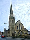 | About 1890 | II | |
| Chesterman House and Wycliffe House 53°24′28″N 1°27′28″W / 53.40779°N 1.45765°W / 53.40779; -1.45765 (Chesterman House, Wycliffe House, main outbuilding range and boundary walls) | Herries Road | 1894 | Designed by C. J. Innocent | II | |
| St Cuthbert 53°24′28″N 1°27′06″W / 53.40784°N 1.45154°W / 53.40784; -1.45154 (CHURCH OF ST CUTHBERT) | Barnsley Road |  | 1904 | Designed by John Dodsley Webster and Son | II |
| Firth Park Methodist Church 53°25′07″N 1°26′54″W / 53.41851°N 1.44830°W / 53.41851; -1.44830 (FIRTH PARK METHODIST CHURCH, ADJOINING MEETING ROOM AND BOUNDARY WALL) | Stubbin Lane |  | 1911 | Designed by F. W. Chapman and J. Mansell Jenkinson | II |
| St James and St Christopher 53°25′43″N 1°26′32″W / 53.42871°N 1.44233°W / 53.42871; -1.44233 (CHURCH OF ST JAMES AND ST CHRISTOPHER) | Bellhouse Road |  | 1941 | II | |
| St James and St Christopher Wall and Gates 53°25′43″N 1°26′31″W / 53.42865°N 1.44203°W / 53.42865; -1.44203 (BOUNDARY WALL AND GATES TO CHURCH OF ST JAMES AND ST CHRISTOPHER) | Bellhouse Road |  | 1941 | II | |
| St Paul 53°25′59″N 1°28′09″W / 53.43317°N 1.46930°W / 53.43317; -1.46930 (CHURCH OF ST PAUL) | Wordsworth Avenue |  | 1959 | Designed by Basil Spence | II* |
References
- [1] – A list of all the listed buildings within Sheffield City Council's boundary is available to download from this page.
Sources
- Historic England. "Listed Buildings". Retrieved 26 July 2022.
- v
- t
- e
- Abbeydale Industrial Hamlet Housing
- Arts Tower and Library
- Beauchief Abbey
- Beauchief Hall
- Beehive Works
- Bishops' House
- Botanical Gardens Glasshouses
- Broom Hall
- Butchers Wheel
- City Hall
- Cornish Place
- Cutlers' Hall
- Darnall Works
- Ecclesfield Priory
- Endcliffe Hall
- Fair House Farmhouse
- General Cemetery
- Globe Works
- Green Lane Works Gateway
- Heritage House
- King Edward VII Upper School
- Leah's Yard
- Little Matlock Rolling Mill
- Loxley United Reformed Church
- Lyceum Theatre
- Manor Lodge Turret House
- Mappin Art Gallery
- The Mount
- Mount Pleasant
- Norton Hall
- Oakes Park
- Old Hall Farmhouse
- Old Queen's Head
- Onesacre Hall
- Paradise Square
- Park Hill Flats
- St James, Midhopestones
- St James, Norton
- St John, Ranmoor
- St Mary, Bramall Lane
- St Mary the Virgin, Beighton
- St Paul, Wordsworth Avenue
- Sharrow Mills
- Victoria Quays Terminal Warehouse
- War Memorial
- Well Meadow Street Crucible Furnace
- Whitley Hall Hotel
- Wicker Arches


