Meall Ghaordaidh
| Meall Ghaordaidh | |
|---|---|
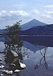
 Meall Ghaordaidh (centre) from An Grianan looking over Glen Lyon, with Stronuich Reservoir (bottom left) | |
| Highest point | |
| Elevation | 1,039 m (3,409 ft)[1] |
| Prominence | 492 m (1,614 ft) |
| Listing | Munro, Marilyn |
| Naming | |
| English translation | Possibly derived from gairdean (shoulder, hand or arm) |
| Language of name | Gaelic |
| Geography | |
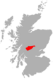
| Location | Stirlingshire, Scotland |
| Parent range | Grampians |
| OS grid | NN514397 |
| Topo map | OS Landranger 51 |
Meall Ghaordaidh is a mountain in the Southern Highlands of Scotland, approximately 10 km north-west of Killin.
The mountain can be ascended via Glen Lochay starting to the north-west of the Allt Dhùin Croisg near Duncroisk, via an eroded path leading north-west through peat bogs to the summit; alternatively, an ascent can be made from Glen Lyon starting at Stronuich via one of two spurs that lead to the summit (Creag an Tulabhain or Creag Laoghain). The summit is marked by a large circular rock windbreak, within which there is a trig point.
References
- ^ "walkhighlands Meall Ghaordaidh". walkhighlands.co.uk. 2013. Retrieved 26 October 2013.
- v
- t
- e
Munros of Scotland: Loch Rannoch to Loch Tay
- An Stùc
- Beinn Achaladair
- Beinn Challuim
- Beinn a' Chreachain
- Beinn Dòrain
- Beinn an Dòthaidh
- Beinn Ghlas
- Beinn Heasgarnich
- Ben Lawers
- Beinn Mhanach
- Càrn Gorm
- Càrn Mairg
- Creag Mhòr
- Meall Corranaich
- Meall nan Aighean
- Meall Buidhe
- Meall a' Choire Leith
- Meall Ghaordaidh
- Meall Garbh (Càrn Mairg Group)
- Meall Garbh (Lawers Group)
- Meall Glas
- Meall Greigh
- Meall nan Tarmachan
- Schiehallion
- Sgiath Chùil
- Stuchd an Lochain
56°31′33″N 4°25′02″W / 56.52577°N 4.41735°W / 56.52577; -4.41735


