Megchelen
Buurtschap in Gelderland, Netherlands
51°50′16″N 6°23′34″E / 51.83778°N 6.39278°E / 51.83778; 6.39278 (2007)
Megchelen is a village in the Dutch province of Gelderland. It is a tiny hook of land surrounded on three sides by the German border in the municipality of Oude IJsselstreek, about 7 km southeast of the town of Ulft on the Zwanenburgseweg.[1]
List of Rijksmonuments in Megchelen
Megchelen is home to 7 rijksmonuments.
| Description | Original function? | Built | Architect | Location | Coordinates? | No.? | Image
|
|---|---|---|---|---|---|---|---|
| Dutch reformed church |  Kerk en kerkonderdeel Kerk en kerkonderdeel | 1411 | Koninginneweg 14 | 51°50′14″N 6°23′39″E / 51.83712°N 6.39418°E / 51.83712; 6.39418 (RM16071 - Koninginneweg 14) | 16071 | 
| |
| Landfort, main building | Kasteel, buitenplaats | 1825-1827 | Landfortseweg 4 | 51°51′11″N 6°24′25″E / 51.85315°N 6.40683°E / 51.85315; 6.40683 (RM512220 - Landfortseweg 4) | 512220 | 
| |
| Landfort, court and park | Tuin, park en plantsoen | Landfortseweg bij 4 | 51°51′10″N 6°24′10″E / 51.85267°N 6.40280°E / 51.85267; 6.40280 (RM512223 - Landfortseweg bij 4) | 512223 | 
| ||
| Landfort, bridge | Tuin, park en plantsoen | 1903 | Landfortseweg bij 4 | 51°51′10″N 6°24′10″E / 51.85267°N 6.40280°E / 51.85267; 6.40280 (RM512224 - Landfortseweg bij 4) | 512224 | 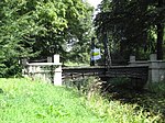
| |
| Landfort, dovecote | Tuin, park en plantsoen | 1825 | Landfortseweg bij 4 | 51°51′10″N 6°24′10″E / 51.85267°N 6.40280°E / 51.85267; 6.40280 (RM512225 - Landfortseweg bij 4) | 512225 | 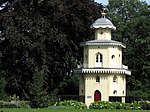
| |
| Landfort, garden wall | Tuin, park en plantsoen | Landfortseweg bij 4 | 51°51′10″N 6°24′10″E / 51.85267°N 6.40280°E / 51.85267; 6.40280 (RM512226 - Landfortseweg bij 4) | 512226 | 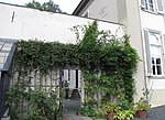
| ||
| Landfort, iron bridge | Tuin, park en plantsoen | 1872 | Landfortseweg bij 4 | 51°51′10″N 6°24′10″E / 51.85267°N 6.40280°E / 51.85267; 6.40280 (RM512227 - Landfortseweg bij 4) | 512227 |  |
References
- ^ ANWB Topografische Atlas Nederland, Topografische Dienst and ANWB, 2005.
- Gemeente Oude IJsselstreek website
- v
- t
- e
Populated places in the municipality of Oude IJsselstreek
- Terborg
- Ulft
- Bontebrug
- Breedenbroek
- Etten
- Gendringen
- Megchelen
- Netterden
- Silvolde
- Sinderen
- Varsselder
- Varsseveld
- Westendorp [nl]
51°50′16″N 6°23′34″E / 51.83778°N 6.39278°E / 51.83778; 6.39278
 | This Gelderland location article is a stub. You can help Wikipedia by expanding it. |
- v
- t
- e


