Mount Aetna, Pennsylvania
Census-designated place in Pennsylvania, United States
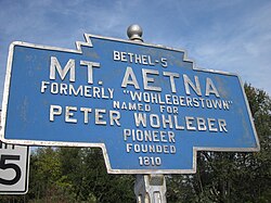
Keystone Marker
[1]
(2020)[2]
19544
Mount Aetna is a census-designated place[3] in Tulpehocken Township, Berks County, Pennsylvania, United States. It is located along Pennsylvania Route 501 near the border of Lebanon County. The community is named after the active volcano, Mount Etna, in Sicily. As of the 2010 census, the population was 354 residents.[4]
Demographics
| Census | Pop. | Note | %± |
|---|---|---|---|
| 2020 | 489 | — | |
| U.S. Decennial Census[5] | |||
References
- ^ "ArcGIS REST Services Directory". United States Census Bureau. Retrieved October 12, 2022.
- ^ "Census Population API". United States Census Bureau. Retrieved October 12, 2022.
- ^ "By Decade".
- ^ https://www.census.gov/# [not specific enough to verify]
- ^ "Census of Population and Housing". Census.gov. Retrieved June 4, 2016.
See also
 Media related to Mount Aetna, Pennsylvania at Wikimedia Commons
Places adjacent to Mount Aetna, Pennsylvania | ||||||||||||||||
|---|---|---|---|---|---|---|---|---|---|---|---|---|---|---|---|---|
| ||||||||||||||||


- v
- t
- e
Municipalities and communities of Berks County, Pennsylvania, United States
County seat: Reading

- Albany
- Alsace
- Amity
- Bern
- Bethel
- Brecknock
- Caernarvon
- Centre
- Colebrookdale
- Cumru
- District
- Douglass
- Earl
- Exeter
- Greenwich
- Heidelberg
- Hereford
- Jefferson
- Longswamp
- Lower Alsace
- Lower Heidelberg
- Maidencreek
- Marion
- Maxatawny
- Muhlenberg
- North Heidelberg
- Oley
- Ontelaunee
- Penn
- Perry
- Pike
- Richmond
- Robeson
- Rockland
- Ruscombmanor
- South Heidelberg
- Spring
- Tilden
- Tulpehocken
- Union
- Upper Bern
- Upper Tulpehocken
- Washington
- Windsor
- Alleghenyville
- Alsace Manor
- Amity Gardens
- Baumstown
- Bethel
- Blandon
- Bowers
- Colony Park
- Dauberville
- Douglassville
- Dryville
- Edenburg
- Flying Hills
- Fox Chase
- Frystown
- Gibraltar
- Gouglersville
- Greenfields
- Grill
- Hereford
- Hyde Park
- Jacksonwald
- Kempton
- Kutztown University
- Lincoln Park
- Lorane
- Maxatawny
- Mertztown
- Mohrsville
- Montrose Manor
- Morgantown‡
- Mount Aetna
- Muhlenberg Park
- New Berlinville
- New Jerusalem
- New Schaefferstown
- Oley
- Penn State Berks
- Pennside
- Pennwyn
- Rehrersburg
- Reiffton
- Riverview Park
- Schubert
- Shartlesville
- South Temple
- Spring Ridge
- Springmont
- Stony Creek Mills
- Stouchsburg
- Strausstown
- Temple
- Virginville
- Walnuttown
- West Hamburg
- West Lawn
- West Wyomissing
- Whitfield
communities
- Albany
- Amityville
- Barto
- Basket
- Beckersville
- Berne
- Boyers Junction
- Breezy Corner
- Brownsville
- Cacoosing
- Chapel‡
- Clayton
- Dale
- Earlville
- Dreibelbis
- Eagle Point
- Eckville
- Eshbach
- Evansville
- Five Points
- Fredericksville
- Fritztown
- Geigertown
- Greenawald
- Green Hills
- Grimville
- Hancock
- Harlem
- Henningsville
- Hinterleiter
- Host
- Huffs Church
- Jalappa
- Joanna
- Joanna Heights
- Kempville
- Kirbyville
- Klinesville
- Knauers
- Krumsville
- Kulptown
- Landis Store
- Leinbachs
- Limekiln
- Lobachsville
- Longswamp
- Maiden Creek
- Manatawny
- Maple Grove
- Molltown
- Monocacy Station
- Montello
- Monterey
- Morysville
- Moselem
- Moselem Springs
- New Hensingersville
- Pikeville
- Pine Forge
- Pleasant Valley
- Pleasantville
- Plowville
- Pricetown
- Quaker City
- Rittenhouse Gap
- Sally Ann
- Scarlets Mill
- Seisholtzville
- State Hill
- Stony Run
- Trexler
- Tuckerton
- Unionville
- Vinemont
- Weavertown
- Windsor Castle
- Wintersville
- Woodchoppertown
- Wyomissing Hills
- Yellow House
‡This populated place also has portions in an adjacent county or counties
- Pennsylvania portal
- United States portal
40°25′09″N 76°17′43″W / 40.41917°N 76.29528°W / 40.41917; -76.29528
Authority control databases | |
|---|---|
| International |
|
| National |
|
| Other |
|
 | This Berks County, Pennsylvania state location article is a stub. You can help Wikipedia by expanding it. |
- v
- t
- e


