Mount Lefroy
Mountain in Alberta/BC, Canada


Mount Lefroy
Location on Alberta/B.C. border
Show map of Alberta
Mount Lefroy
Mount Lefroy (British Columbia)
Show map of British Columbia- Banff National Park
- Yoho National Park
Mount Lefroy is a mountain on the Continental Divide, at the border of Alberta and British Columbia in western Canada. The mountain is located on the eastern side of Abbot Pass which separates Lake Louise in Banff National Park from Lake O'Hara in Yoho National Park. Mount Victoria lies immediately on the western side of the pass.
The mountain was named by George M. Dawson in 1894 for Sir John Henry Lefroy (1817–1890), an astronomer who had travelled over 8,800 kilometres (5,470 mi) in Canada's north between 1842 and 1844 making meteorological and magnetic observations.[1]
The mountain is the site of the first fatal accident in modern mountaineering in Canada. In 1896 during a failed summit bid, Philip Stanley Abbot slipped on rocks after just coming off an icy section and plummeted down the rock face to his death.[1]
The first successful ascent was made in 1897 by J. Norman Collie, Arthur Michael, H. Dixon; Charles Fay, Peter Sarbach, R. Vanderlip, C. Noyes, Charles Thompson, and H. Parker.[3]
A prominent painting by Canadian Group of 7 artist Lawren Harris, was painted at this site.[5]
Geology
Mount Lefroy is composed of sedimentary rock laid down during the Cambrian period. Formed in shallow seas, this sedimentary rock was pushed east and over the top of younger rock during the Laramide orogeny.[6]
Climate
Based on the Köppen climate classification, Mount Lefroy is located in a subarctic climate zone with cold, snowy winters, and mild summers.[7] Winter temperatures can drop below −20 °C with wind chill factors below −30 °C.
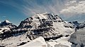
Gallery
-
 North aspect, with The Mitre to left
 -
 Northeast aspect
 -
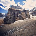 Mount Lefroy north aspect, and Victoria Glacier
 -

-
 Northwest aspect
 -

-
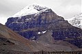
 Mt. Lefroy and Mt. Victoria (right)
 -


References
- ^ a b c d "Mount Lefroy". cdnrockiesdatabases.ca. Retrieved 2019-08-17.
- ^ "Topographic map of Mount Lefroy". opentopomap.org. Retrieved 2023-07-23.
- ^ a b c "Mount Lefroy". Bivouac.com. Retrieved 2008-10-05.
- ^ a b "Mount Lefroy". BC Geographical Names. Retrieved 2012-08-08.
- ^ "Lawren S. Harris, Mt. Lefroy, 1930". Art!Facts. McMichael Canadian Art Collection. 2006. Archived from the original on 2013-01-15. Retrieved 2010-08-11.
- ^ Gadd, Ben (2008). Geology of the Rocky Mountains and Columbias.
- ^ Peel, M. C.; Finlayson, B. L.; McMahon, T. A. (2007). "Updated world map of the Köppen−Geiger climate classification". Hydrol. Earth Syst. Sci. 11: 1633–1644. ISSN 1027-5606.
External links
- Mount Lefroy weather: Mountain Forecast
- Parks Canada web site: Banff National Park
- v
- t
- e
- Ball
- Bare
- Beaverfoot
- Blue
- Bow
- Crowsnest
- Elk
- Fairholme
- Fiddle
- Flathead
- Foothills
- High Rock
- Kananaskis
- Livingstone
- Lizard
- Maligne
- Massive
- Misty
- Morrissey
- Palliser
- President
- Queen Elizabeth
- Rainbow
- Ram
- Sawback
- Sentinel
- Slate
- South Jasper
- Sundance
- Terminal
- Tower of London
- Vermilion
- Victoria Cross
- Waputik
- Winston Churchill
- Continental Ranges
- Hart Ranges
- Muskwa Ranges
- Alberta
- Andromeda
- Assiniboine
- Athabasca
- Brazeau
- Bryce
- Cascade
- Castle
- Castleguard
- Clemenceau
- Columbia
- Cory
- Edith Cavell
- Forbes
- Hector
- Hosmer
- Hungabee
- Joffre
- Kitchener
- Lyell
- Heart
- Pilot
- Pyramid
- Resplendent
- Robson
- Rundle
- Sarbach
- Saskatchewan
- Smythe
- Snow Dome
- Stanley Peak
- Sulphur
- Temple
- Three Sisters
- Trinity
- Twin
- Ulysses
- Unnamed Alberta–BC mountain (formerly Mount Pétain)
- Whymper
see List of rivers of the Canadian Rockies and Category:Rivers of the Canadian Rockies
- Mountain Stoney
- Mountain Metis
| International | |
|---|---|
| National |
|
| Provincial (AB) |
|
| Provincial (BC) |
- See also
- Geography portal
- Canada portal


