National Register of Historic Places listings in Boundary County, Idaho

This is a list of the National Register of Historic Places listings in Boundary County, Idaho.
This is intended to be a complete list of the properties and districts on the National Register of Historic Places in Boundary County, Idaho, United States. Latitude and longitude coordinates are provided for many National Register properties and districts; these locations may be seen together in a map.[1]
There are 9 properties and districts listed on the National Register in the county. More may be added; properties and districts nationwide are added to the Register weekly.[2]
This National Park Service list is complete through NPS recent listings posted August 30, 2024.[3]
Map all coordinates using OpenStreetMap
Download coordinates as:
- KML
- GPX (all coordinates)
- GPX (primary coordinates)
- GPX (secondary coordinates)
Current listings
| [4] | Name on the Register[5] | Image | Date listed[6] | Location | City or town | Description |
|---|---|---|---|---|---|---|
| 1 | Boundary County Courthouse | 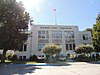 | September 27, 1987 (#87001581) | Kootenai St. 48°41′45″N 116°18′50″W / 48.695884°N 116.313877°W / 48.695884; -116.313877 (Boundary County Courthouse) | Bonners Ferry | |
| 2 | Fry's Trading Post |  | September 7, 1984 (#84001104) | Off U.S. Route 95 48°42′00″N 116°18′59″W / 48.7°N 116.316389°W / 48.7; -116.316389 (Fry's Trading Post) | Bonners Ferry | Destroyed by fire.[7] |
| 3 | Harvey Mountain Quarry | 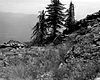 | June 23, 1978 (#78001053) | Address restricted[8] | Bonners Ferry | |
| 4 | North Side School | 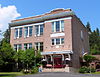 | May 5, 1992 (#92000417) | 218 W. Comanche St. 48°42′11″N 116°18′56″W / 48.702990°N 116.315493°W / 48.702990; -116.315493 (North Side School) | Bonners Ferry | |
| 5 | Snyder Guard Station Historical District | Upload image | August 19, 1983 (#83000283) | South of Eastport on United States Forest Service Road 211 48°53′04″N 116°10′12″W / 48.884456°N 116.169994°W / 48.884456; -116.169994 (Snyder Guard Station Historical District) | Eastport | |
| 6 | Russell and Pearl Soderling House |  | January 15, 1998 (#97001650) | 217 W. Madison St. 48°41′28″N 116°19′09″W / 48.691166°N 116.319133°W / 48.691166; -116.319133 (Russell and Pearl Soderling House) | Bonners Ferry | |
| 7 | Spokane & International Railroad Construction Camp | Upload image | June 23, 1994 (#94000630) | East of U.S. Route 95 along the Spokane International railroad tracks, 2 miles (3.2 km) south of the Canada–US border 48°57′58″N 116°10′12″W / 48.966111°N 116.17°W / 48.966111; -116.17 (Spokane & International Railroad Construction Camp) | Eastport | |
| 8 | U.S. Inspection Station – Porthill, Idaho | 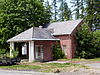 | May 22, 2014 (#14000252) | Idaho Highway 1 48°59′59″N 116°29′54″W / 48.999730°N 116.498369°W / 48.999730; -116.498369 (U.S. Inspection Station – Porthill, Idaho) | Porthill | |
| 9 | U.S. Post Office – Bonners Ferry Main | 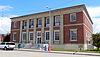 | March 16, 1989 (#89000129) | 7167 1st St. 48°41′47″N 116°18′47″W / 48.696447°N 116.312952°W / 48.696447; -116.312952 (U.S. Post Office – Bonners Ferry Main) | Bonners Ferry |
See also
Wikimedia Commons has media related to National Register of Historic Places in Boundary County, Idaho.
References
- ^ The latitude and longitude information provided in this table was derived originally from the National Register Information System, which has been found to be fairly accurate for about 99% of listings. Some locations in this table may have been corrected to current GPS standards.
- ^ "National Register of Historic Places: Weekly List Actions". National Park Service. Retrieved March 29, 2009.
- ^ National Park Service, United States Department of the Interior, "National Register of Historic Places: Weekly List Actions", retrieved August 30, 2024.
- ^ Numbers represent an alphabetical ordering by significant words. Various colorings, defined here, differentiate National Historic Landmarks and historic districts from other NRHP buildings, structures, sites or objects.
- ^ "National Register Information System". National Register of Historic Places. National Park Service. April 24, 2008.
- ^ The eight-digit number below each date is the number assigned to each location in the National Register Information System database, which can be viewed by clicking the number.
- ^ Boundary County (July 21, 2008), Boundary County Comprehensive Plan, sec. 7.3.2, archived from the original on March 17, 2015, retrieved May 22, 2017.
- ^ Federal and state laws and practices restrict general public access to information regarding the specific location of this resource. In some cases, this is to protect archeological sites from vandalism, while in other cases it is restricted at the request of the owner. See: Knoerl, John; Miller, Diane; Shrimpton, Rebecca H. (1990), Guidelines for Restricting Information about Historic and Prehistoric Resources, National Register Bulletin, National Park Service, U.S. Department of the Interior, OCLC 20706997.
- v
- t
- e
- Ada
- Adams
- Bannock
- Bear Lake
- Benewah
- Bingham
- Blaine
- Boise
- Bonner
- Bonneville
- Boundary
- Butte
- Camas
- Canyon
- Caribou
- Cassia
- Clark
- Clearwater
- Custer
- Elmore
- Franklin
- Fremont
- Gem
- Gooding
- Idaho
- Jefferson
- Jerome
- Kootenai
- Latah
- Lemhi
- Lewis
- Lincoln
- Madison
- Minidoka
- Nez Perce
- Oneida
- Owyhee
- Payette
- Power
- Shoshone
- Teton
- Twin Falls
- Valley
- Washington

| |
|---|---|
| Topics | |
| Lists by state |
|
| Lists by insular areas | |
| Lists by associated state | |
| Other areas | |
| Related | |
| |


Municipalities and communities of Boundary County, Idaho, United States | ||
|---|---|---|
County seat: Bonners Ferry | ||
| Cities |  | |
| Unincorporated communities | ||
| Indian reservation | ||
| ||


