National Register of Historic Places listings in Mitchell County, Kansas
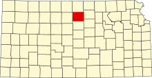
This is a list of the National Register of Historic Places listings in Mitchell County, Kansas.
This is intended to be a complete list of the properties and districts on the National Register of Historic Places in Mitchell County, Kansas, United States. The locations of National Register properties and districts for which the latitude and longitude coordinates are included below, may be seen in a map.[1]
There are 13 properties and districts listed on the National Register in the county.
This National Park Service list is complete through NPS recent listings posted August 30, 2024.[2]
Map all coordinates using OpenStreetMap
Download coordinates as:
- KML
- GPX (all coordinates)
- GPX (primary coordinates)
- GPX (secondary coordinates)
Current listings
| [3] | Name on the Register[4] | Image | Date listed[5] | Location | City or town | Description |
|---|---|---|---|---|---|---|
| 1 | Antelope Creek Masonry Arch Bridge |  | July 25, 2014 (#14000437) | Mile 1000 on County Road 210 39°22′01″N 98°17′02″W / 39.367029°N 98.283808°W / 39.367029; -98.283808 (Antelope Creek Masonry Arch Bridge) | Tipton | |
| 2 | Brown's Creek Tributary Masonry Arch Bridge |  | July 25, 2014 (#14000438) | Mile 2300 on County Road B 39°33′13″N 98°14′32″W / 39.553595°N 98.242211°W / 39.553595; -98.242211 (Brown's Creek Tributary Masonry Arch Bridge) | Glen Elder | |
| 3 | Cather Farm |  | June 27, 2007 (#07000611) | 4 miles north of the junction of K-15 and K-24 39°32′27″N 98°06′55″W / 39.540834°N 98.115391°W / 39.540834; -98.115391 (Cather Farm) | Beloit | |
| 4 | Abram Click Farmstead | 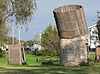 | June 25, 2013 (#13000432) | 2030 Independence Avenue 39°28′51″N 98°06′59″W / 39.48084°N 98.11642°W / 39.48084; -98.11642 (Abram Click Farmstead) | Beloit | |
| 5 | E. W. Norris Service Station |  | December 12, 1976 (#76000832) | Market and Main Sts. 39°29′56″N 98°18′24″W / 39.498889°N 98.306667°W / 39.498889; -98.306667 (E. W. Norris Service Station) | Glen Elder | |
| 6 | F. H. Hart House | 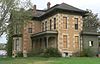 | January 29, 1973 (#73000769) | 304 E. Main St. 39°27′31″N 98°06′26″W / 39.458686°N 98.107235°W / 39.458686; -98.107235 (F. H. Hart House) | Beloit | |
| 7 | Mitchell County Courthouse |  | November 23, 1977 (#77000591) | Main St. and Hersey Ave. 39°27′31″N 98°06′30″W / 39.458649°N 98.108463°W / 39.458649; -98.108463 (Mitchell County Courthouse) | Beloit | |
| 8 | North Rock Creek Masonry Arch Bridge | 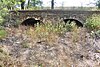 | July 25, 2014 (#14000439) | V Rd., .4 mi. E. of 190th Rd. 39°15′48″N 98°18′50″W / 39.263213°N 98.313822°W / 39.263213; -98.313822 (North Rock Creek Masonry Arch Bridge) | Hunter | |
| 9 | Old Cawker City Library | 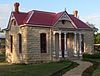 | March 7, 1973 (#73000770) | 7th and Lake Sts. 39°30′39″N 98°25′58″W / 39.510806°N 98.432839°W / 39.510806; -98.432839 (Old Cawker City Library) | Cawker City | |
| 10 | C. A. Perdue House | 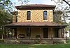 | December 12, 1976 (#76000831) | 422 W. 8th St. 39°28′01″N 98°06′56″W / 39.467003°N 98.115582°W / 39.467003; -98.115582 (C. A. Perdue House) | Beloit | |
| 11 | Porter Hotel |  | July 23, 2004 (#04000725) | 209 E. Main St. 39°27′33″N 98°06′30″W / 39.459275°N 98.108342°W / 39.459275; -98.108342 (Porter Hotel) | Beloit | |
| 12 | St. John the Baptist Catholic Church | 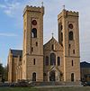 | April 14, 1975 (#75000717) | 701 E. Court St. 39°27′31″N 98°06′09″W / 39.458595°N 98.102369°W / 39.458595; -98.102369 (St. John the Baptist Catholic Church) | Beloit | |
| 13 | Wisconsin Street Historic District | 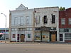 | June 11, 1986 (#86001324) | 700 block of Wisconsin St. 39°30′37″N 98°25′58″W / 39.510278°N 98.432778°W / 39.510278; -98.432778 (Wisconsin Street Historic District) | Cawker City |
See also
Wikimedia Commons has media related to National Register of Historic Places in Mitchell County, Kansas.
- List of National Historic Landmarks in Kansas
- National Register of Historic Places listings in Kansas
References
- ^ The latitude and longitude information provided in this table was derived originally from the National Register Information System, which has been found to be fairly accurate for about 99% of listings. Some locations in this table may have been corrected to current GPS standards.
- ^ National Park Service, United States Department of the Interior, "National Register of Historic Places: Weekly List Actions", retrieved August 30, 2024.
- ^ Numbers represent an alphabetical ordering by significant words. Various colorings, defined here, differentiate National Historic Landmarks and historic districts from other NRHP buildings, structures, sites or objects.
- ^ "National Register Information System". National Register of Historic Places. National Park Service. March 13, 2009.
- ^ The eight-digit number below each date is the number assigned to each location in the National Register Information System database, which can be viewed by clicking the number.
- v
- t
- e

- Allen
- Anderson
- Atchison
- Barber
- Barton
- Bourbon
- Brown
- Butler
- Chase
- Chautauqua
- Cherokee
- Cheyenne
- Clark
- Clay
- Cloud
- Coffey
- Comanche
- Cowley
- Crawford
- Decatur
- Dickinson
- Doniphan
- Douglas
- Edwards
- Elk
- Ellis
- Ellsworth
- Finney
- Ford
- Franklin
- Geary
- Gove
- Graham
- Grant
- Gray
- Greeley
- Greenwood
- Hamilton
- Harper
- Harvey
- Haskell
- Hodgeman
- Jackson
- Jefferson
- Jewell
- Johnson
- Kearny
- Kingman
- Kiowa
- Labette
- Lane
- Leavenworth
- Lincoln
- Linn
- Logan
- Lyon
- Marion
- McPherson
- Meade
- Miami
- Mitchell
- Montgomery
- Morris
- Morton
- Nemaha
- Neosho
- Ness
- Norton
- Osage
- Osborne
- Ottawa
- Pawnee
- Phillips
- Pottawatomie
- Pratt
- Rawlins
- Reno
- Republic
- Rice
- Riley
- Rooks
- Rush
- Russell
- Saline
- Scott
- Sedgwick
- Seward
- Shawnee
- Sheridan
- Sherman
- Smith
- Stafford
- Stanton
- Stevens
- Sumner
- Thomas
- Trego
- Wabaunsee
- Wallace
- Washington
- Wichita
- Wilson
- Woodson
- Wyandotte
- Archaeological sites
- National Historic Landmarks
 Category
 NRHP portal


Municipalities and communities of Mitchell County, Kansas, United States | ||
|---|---|---|
County seat: Beloit | ||
| Cities |  | |
| CDP | ||
| Unincorporated community | ||
| Ghost towns | ||
| Townships |
| |
| Footnotes | ‡This community also has portions in an adjacent county or counties. | |
| ||


