National Register of Historic Places listings in Montgomery County, Virginia

This is a list of the National Register of Historic Places listings in Montgomery County, Virginia.
This is intended to be a complete list of the properties and districts on the National Register of Historic Places in Montgomery County, Virginia, United States. The locations of National Register properties and districts for which the latitude and longitude coordinates are included below, may be seen in an online map.[1]
There are 71 properties and districts listed on the National Register in the county. Another 4 properties were once listed but have been removed.
This National Park Service list is complete through NPS recent listings posted May 31, 2024.[2]
Map all coordinates using OpenStreetMap
Download coordinates as:
- KML
- GPX (all coordinates)
- GPX (primary coordinates)
- GPX (secondary coordinates)
Current listings
| [3] | Name on the Register[4] | Image | Date listed[5] | Location | City or town | Description |
|---|---|---|---|---|---|---|
| 1 | Alleghany Springs Springhouse | 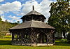 | November 13, 1989 (#89001807) | Alleghany Spring Rd. 37°07′40″N 80°15′51″W / 37.127778°N 80.264028°W / 37.127778; -80.264028 (Alleghany Springs Springhouse) | Alleghany Springs | |
| 2 | Amiss-Palmer House |  | November 13, 1989 (#89001804) | Mountain View Dr. and Penn St. off Eakin St. 37°13′36″N 80°24′26″W / 37.226667°N 80.407222°W / 37.226667; -80.407222 (Amiss-Palmer House) | Blacksburg | |
| 3 | Barnett House |  | November 13, 1989 (#89001810) | U.S. Routes 11/460, 0.3 miles (0.48 km) south of their junction with Brake Rd. 37°12′39″N 80°14′00″W / 37.210972°N 80.233333°W / 37.210972; -80.233333 (Barnett House) | Elliston | |
| 4 | William Barnett House |  | November 13, 1989 (#89001806) | Off Alleghany Spring Rd., 0.1 miles (0.16 km) north of Georges Run Rd. 37°08′36″N 80°16′02″W / 37.143333°N 80.267222°W / 37.143333; -80.267222 (William Barnett House) | Alleghany Springs | |
| 5 | Barracks No. 1 |  | November 19, 2014 (#14000947) | 280 Alumni Mall 37°13′51″N 80°25′11″W / 37.23083°N 80.419722°W / 37.23083; -80.419722 (Barracks No. 1) | Blacksburg | Lane Hall on the Virginia Tech campus |
| 6 | Big Spring Baptist Church | 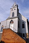 | November 13, 1989 (#89001809) | Brake Rd., 0.1 miles (0.16 km) east of U.S. Routes 11/460 37°12′56″N 80°13′29″W / 37.215556°N 80.224861°W / 37.215556; -80.224861 (Big Spring Baptist Church) | Elliston | |
| 7 | Bishop House |  | November 13, 1989 (#89001812) | 0.1 miles (0.16 km) north of the junction of Graysontown and Lead Mine Rds. 37°02′17″N 80°33′19″W / 37.038056°N 80.555278°W / 37.038056; -80.555278 (Bishop House) | Graysontown | |
| 8 | Blacksburg Historic District |  | January 31, 1991 (#90002165) | Roughly the area north of the junction of Main and Jackson Sts., including sections out along Lee and Progress Sts. 37°13′51″N 80°24′48″W / 37.230833°N 80.413333°W / 37.230833; -80.413333 (Blacksburg Historic District) | Blacksburg | |
| 9 | Blacksburg Motor Company, Inc. |  | February 21, 2008 (#08000074) | 400 S. Main St. 37°13′37″N 80°24′42″W / 37.226944°N 80.411667°W / 37.226944; -80.411667 (Blacksburg Motor Company, Inc.) | Blacksburg | |
| 10 | Blankenship Farm |  | November 13, 1989 (#89001808) | 0.4 miles (0.64 km) south of the junction of Ellett and Sweeny Rds. 37°11′05″N 80°21′51″W / 37.184722°N 80.364167°W / 37.184722; -80.364167 (Blankenship Farm) | Ellett | |
| 11 | Bowstring Truss Bridge |  | January 2, 2013 (#12001136) | Ironto Rest Area on Interstate 81 37°14′21″N 80°13′28″W / 37.23921°N 80.22444°W / 37.23921; -80.22444 (Bowstring Truss Bridge) | Ironto | |
| 12 | Bowyer-Trollinger Farm | 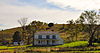 | February 1, 1991 (#90002167) | Tyler Rd., north of its junction with Childress Rd. 37°04′02″N 80°30′24″W / 37.067361°N 80.506667°W / 37.067361; -80.506667 (Bowyer-Trollinger Farm) | Childress | |
| 13 | Pompey Callaway House | 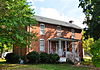 | November 13, 1989 (#89001811) | Calloway St., 0.2 miles (0.32 km) east of U.S. Routes 11/460 37°13′00″N 80°13′48″W / 37.216667°N 80.230000°W / 37.216667; -80.230000 (Pompey Callaway House) | Elliston | |
| 14 | Cambria Freight Station | 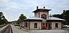 | December 12, 1985 (#85003351) | 630 Depot St. 37°08′29″N 80°24′17″W / 37.141389°N 80.404722°W / 37.141389; -80.404722 (Cambria Freight Station) | Christiansburg | |
| 15 | Cambria Historic District |  | January 10, 1991 (#90002002) | 500-600 blocks of Depot St., the 500-600 blocks of Montgomery St., the 900-1000 blocks of Cambria St., and railroad depots 37°08′35″N 80°24′19″W / 37.143056°N 80.405278°W / 37.143056; -80.405278 (Cambria Historic District) | Christiansburg | |
| 16 | James Charlton Farm |  | November 13, 1989 (#89001816) | Mud Pike east of State Route 177 37°05′50″N 80°29′49″W / 37.097361°N 80.496944°W / 37.097361; -80.496944 (James Charlton Farm) | Radford | |
| 17 | Christiansburg Downtown Historic District |  | May 28, 2013 (#13000340) | E. and W. Main St., and N. and S. Franklin St. 37°07′47″N 80°24′31″W / 37.129722°N 80.408611°W / 37.129722; -80.408611 (Christiansburg Downtown Historic District) | Christiansburg | Thirty-two contributing buildings, one contributing site, and two contributing objects.[6] |
| 18 | Christiansburg Presbyterian Church |  | January 30, 1978 (#78003031) | 107 W. Main St. 37°07′43″N 80°24′39″W / 37.128611°N 80.410833°W / 37.128611; -80.410833 (Christiansburg Presbyterian Church) | Christiansburg | |
| 19 | Crockett Springs Cottage |  | November 13, 1989 (#89001814) | 1 mile (1.6 km) south of the junction of Alleghany Spring and Fishers View Rds. 37°05′38″N 80°15′07″W / 37.093889°N 80.251944°W / 37.093889; -80.251944 (Crockett Springs Cottage) | Piedmont | |
| 20 | Cromer House |  | November 13, 1989 (#89001893) | Off Dry Valley Rd., 0.25 miles (0.40 km) east of Childress Rd. 37°03′07″N 80°31′34″W / 37.051944°N 80.526111°W / 37.051944; -80.526111 (Cromer House) | Childress | |
| 21 | Currie House |  | September 14, 1994 (#94000549) | 1105 Highland Circle 37°13′26″N 80°23′38″W / 37.223889°N 80.393889°W / 37.223889; -80.393889 (Currie House) | Blacksburg | |
| 22 | Earhart House |  | November 13, 1989 (#89001801) | Lusters Gate Rd., 0.3 miles (0.48 km) north of Sweeny Rd. 37°11′45″N 80°21′58″W / 37.195833°N 80.366111°W / 37.195833; -80.366111 (Earhart House) | Ellett | |
| 23 | George Earhart House |  | November 13, 1989 (#89001886) | Lusters Gate Rd., just north of Taylor Hollow Rd. 37°12′26″N 80°21′43″W / 37.207222°N 80.362083°W / 37.207222; -80.362083 (George Earhart House) | New Ellett | |
| 24 | East Main Street Historic District |  | January 10, 1991 (#90002008) | E. Main St. from Roanoke and Pepper Sts. to the old high school, and Park St. from E. Main to Lester St. 37°07′58″N 80°24′19″W / 37.132778°N 80.405278°W / 37.132778; -80.405278 (East Main Street Historic District) | Christiansburg | |
| 25 | Edgemont Church |  | November 13, 1989 (#89001902) | Mud Pike, 1 mile (1.6 km) east of Violet Dr. 37°06′28″N 80°28′44″W / 37.107778°N 80.478889°W / 37.107778; -80.478889 (Edgemont Church) | Christiansburg | |
| 26 | Evans House No. 2 |  | November 13, 1989 (#89001890) | Prices Fork Rd., 0.5 miles (0.80 km) west of Merrimac Rd. 37°12′50″N 80°28′41″W / 37.213889°N 80.478194°W / 37.213889; -80.478194 (Evans House No. 2) | Prices Fork | |
| 27 | Fotheringay |  | November 12, 1969 (#69000262) | South of the junction of U.S. Route 11 and Brake Rd. 37°11′45″N 80°13′51″W / 37.195833°N 80.230833°W / 37.195833; -80.230833 (Fotheringay) | Elliston | |
| 28 | Nealy Gordon Farm |  | November 13, 1989 (#89001805) | Off Thacler Rd., 0.5 miles (0.80 km) south of the junction with North Fork Rd. 37°11′40″N 80°18′07″W / 37.194444°N 80.301806°W / 37.194444; -80.301806 (Nealy Gordon Farm) | Brush Harbor | |
| 29 | John Grayson House |  | November 13, 1989 (#89001896) | 0.5 miles (0.80 km) northeast of the Graysontown Rd. bridge over the Little River 37°02′53″N 80°33′27″W / 37.047917°N 80.557500°W / 37.047917; -80.557500 (John Grayson House) | Graysontown | |
| 30 | Grayson-Gravely House | 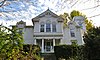 | November 13, 1989 (#89001813) | Graysontown Rd. at the Little River bridge 37°02′36″N 80°33′45″W / 37.043333°N 80.562500°W / 37.043333; -80.562500 (Grayson-Gravely House) | Graysontown | |
| 31 | Graysontown Methodist Church | 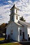 | November 13, 1989 (#89001889) | Graysontown Rd. 37°02′14″N 80°33′38″W / 37.037222°N 80.560556°W / 37.037222; -80.560556 (Graysontown Methodist Church) | Graysontown | |
| 32 | Guerrant House |  | November 13, 1989 (#89001815) | High Rock Hill Rd. at Old Pike Rd. 37°03′15″N 80°21′29″W / 37.054028°N 80.358056°W / 37.054028; -80.358056 (Guerrant House) | Pilot | |
| 33 | Thomas Hall House |  | November 13, 1989 (#89001898) | Tyler Rd., 0.5 miles (0.80 km) southeast of Stanley Rd. 37°04′40″N 80°30′43″W / 37.077778°N 80.511944°W / 37.077778; -80.511944 (Thomas Hall House) | Childress | |
| 34 | Hornbarger Store |  | November 13, 1989 (#89001888) | Vicker Switch Rd., 0.1 miles (0.16 km) east of Switchback Rd. 37°09′50″N 80°29′09″W / 37.163889°N 80.485833°W / 37.163889; -80.485833 (Hornbarger Store) | Vicker | |
| 35 | Howard-Bell-Feather House |  | November 13, 1989 (#89001887) | Union Valley Rd. at Elliott Creek 37°04′01″N 80°24′32″W / 37.0670833°N 80.408889°W / 37.0670833; -80.408889 (Howard-Bell-Feather House) | Riner | |
| 36 | Keister House |  | November 13, 1989 (#89001880) | 607 Giles Rd. 37°14′25″N 80°25′01″W / 37.240278°N 80.416944°W / 37.240278; -80.416944 (Keister House) | Blacksburg | |
| 37 | Kentland Farm Historic and Archeological District |  | July 3, 1991 (#91000833) | At the end of Whitethorne Rd. along the New River; also the western terminus of Whitethorne Rd. 37°11′42″N 80°34′46″W / 37.195000°N 80.579444°W / 37.195000; -80.579444 (Kentland Farm Historic and Archeological District) | Blacksburg | Whitethorne Road represents a boundary increase of September 6, 2006 |
| 38 | Michael Kinzer House |  | November 13, 1989 (#89001901) | Linwood Ln. 37°14′02″N 80°27′31″W / 37.233750°N 80.458611°W / 37.233750; -80.458611 (Michael Kinzer House) | Blacksburg | |
| 39 | Lafayette Historic District |  | January 10, 1991 (#90002005) | Roughly High St. from Main to Washington Sts., Main from High to Water Sts., and Church St. from Main to Washington 37°14′07″N 80°12′39″W / 37.235278°N 80.210833°W / 37.235278; -80.210833 (Lafayette Historic District) | Lafayette | |
| 40 | Frank Lawrence House |  | November 13, 1989 (#89001897) | High Rock Hill Rd., 0.2 miles (0.32 km) east of Tanbark Rd. 37°03′08″N 80°19′05″W / 37.052361°N 80.318056°W / 37.052361; -80.318056 (Frank Lawrence House) | Basham | |
| 41 | Linkous-Kipps House |  | November 13, 1989 (#89001885) | Merrimac Rd. 37°12′27″N 80°27′31″W / 37.207500°N 80.458611°W / 37.207500; -80.458611 (Linkous-Kipps House) | Merrimac | |
| 42 | Edgar A. Long Building |  | March 5, 2001 (#01000149) | 140 Scattergood Dr. 37°08′33″N 80°25′03″W / 37.142500°N 80.417500°W / 37.142500; -80.417500 (Edgar A. Long Building) | Christiansburg | |
| 43 | Madison Farm Historic and Archeological District |  | January 25, 1991 (#90002190) | Eastern and western sides of U.S. Route 460 north of the junction with Dark Run Rd. 37°11′01″N 80°14′06″W / 37.183611°N 80.235000°W / 37.183611; -80.235000 (Madison Farm Historic and Archeological District) | Elliston | |
| 44 | Joseph McDonald Farm |  | February 1, 1991 (#90002166) | Walnut Spring Rd., northwest of the junction with Prices Fork Rd., at the end of a spur road 37°13′36″N 80°28′27″W / 37.226667°N 80.474167°W / 37.226667; -80.474167 (Joseph McDonald Farm) | Prices Fork | |
| 45 | Miller-Southside Residential Historic District |  | January 11, 1991 (#90002110) | Roughly bounded by Miller St., S. Main St., Airport Rd., and Preston Ave. 37°13′18″N 80°24′26″W / 37.221667°N 80.407222°W / 37.221667; -80.407222 (Miller-Southside Residential Historic District) | Blacksburg | |
| 46 | Montgomery Primitive Baptist Church |  | November 13, 1989 (#89001803) | Triangle St., southwest of the junction with U.S. Route 460 Business 37°11′02″N 80°24′39″W / 37.183750°N 80.410833°W / 37.183750; -80.410833 (Montgomery Primitive Baptist Church) | Merrimac | |
| 47 | North Fork Valley Rural Historic District |  | February 1, 1991 (#90002169) | Along the North Fork of the Roanoke River from the Roanoke County line south to Lusters Gate 37°15′51″N 80°19′49″W / 37.264167°N 80.330278°W / 37.264167; -80.330278 (North Fork Valley Rural Historic District) | Blacksburg | |
| 48 | The Oaks | 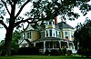 | July 15, 1994 (#94000709) | 311 E. Main St. 37°08′00″N 80°24′16″W / 37.133472°N 80.404444°W / 37.133472; -80.404444 (The Oaks) | Christiansburg | |
| 49 | Odd Fellows Hall |  | July 27, 2005 (#05000770) | 203 Gilbert St. 37°14′04″N 80°25′15″W / 37.234306°N 80.420833°W / 37.234306; -80.420833 (Odd Fellows Hall) | Blacksburg | |
| 50 | Old Christiansburg Industrial Institute |  | April 6, 1979 (#79003056) | 570 High St. 37°08′21″N 80°24′20″W / 37.139167°N 80.405556°W / 37.139167; -80.405556 (Old Christiansburg Industrial Institute) | Christiansburg | |
| 51 | Phillips-Ronald House | 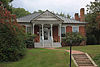 | November 13, 1989 (#89001904) | Draper Rd. at Washington St. 37°13′37″N 80°24′49″W / 37.226944°N 80.413611°W / 37.226944; -80.413611 (Phillips-Ronald House) | Blacksburg | |
| 52 | Phlegar Building | 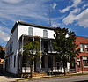 | November 13, 1989 (#89001892) | 2 S. Franklin St. 37°07′46″N 80°24′29″W / 37.129583°N 80.408056°W / 37.129583; -80.408056 (Phlegar Building) | Christiansburg | |
| 53 | Piedmont Camp Meeting Grounds Historic District | 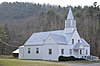 | January 10, 1991 (#90002003) | Junction of Jewell Dr. and Miles Rd. 37°06′13″N 80°13′00″W / 37.103611°N 80.216667°W / 37.103611; -80.216667 (Piedmont Camp Meeting Grounds Historic District) | Piedmont | |
| 54 | Pilot School | Upload image | February 7, 2024 (#100009956) | 4449 Brush Creek Road /Route 617 37°03′02″N 80°21′43″W / 37.0506°N 80.3620°W / 37.0506; -80.3620 (Pilot School) | Pilot | |
| 55 | Prices Fork Historic District |  | January 10, 1991 (#90002004) | Prices Fork Rd. from Thomas Lane roughly to Brooksfield Rd.; also Prices Fork Rd. 37°12′35″N 80°29′27″W / 37.209722°N 80.490833°W / 37.209722; -80.490833 (Prices Fork Historic District) | Prices Fork | Second location represents a boundary increase of August 25, 2014 |
| 56 | Rife House |  | November 13, 1989 (#89001900) | U.S. Routes 11/460 at Dark Run Rd. 37°10′38″N 80°14′12″W / 37.177361°N 80.236667°W / 37.177361; -80.236667 (Rife House) | Shawsville | |
| 57 | Riner Historic District |  | January 10, 1991 (#90002006) | Roughly east and south of the junction of Main and Franklin Sts. 37°04′00″N 80°26′24″W / 37.066667°N 80.440000°W / 37.066667; -80.440000 (Riner Historic District) | Riner | |
| 58 | Shawsville Historic District |  | January 10, 1991 (#90002009) | Main St. east and west of the junction with Alleghany Spring Rd. 37°10′08″N 80°15′16″W / 37.168889°N 80.254444°W / 37.168889; -80.254444 (Shawsville Historic District) | Shawsville | |
| 59 | Slusser-Ryan Farm |  | August 28, 2017 (#100001514) | 2028 Mt. Tabor Rd. 37°17′03″N 80°23′16″W / 37.284028°N 80.387778°W / 37.284028; -80.387778 (Slusser-Ryan Farm) | Blacksburg | |
| 60 | Smithfield |  | November 12, 1969 (#69000261) | West of Blacksburg 37°13′05″N 80°25′55″W / 37.218056°N 80.432083°W / 37.218056; -80.432083 (Smithfield) | Blacksburg | |
| 61 | Solitude |  | May 5, 1989 (#89000363) | Greenhouse Rd. on the Virginia Tech campus 37°13′34″N 80°25′37″W / 37.226111°N 80.426944°W / 37.226111; -80.426944 (Solitude) | Blacksburg | |
| 62 | South Franklin Street Historic District |  | January 10, 1991 (#90002007) | 100-308 S. Franklin St. 37°07′40″N 80°24′22″W / 37.127778°N 80.406111°W / 37.127778; -80.406111 (South Franklin Street Historic District) | Christiansburg | |
| 63 | Surface House |  | November 13, 1989 (#89001883) | High St., east of Depot St. 37°08′21″N 80°24′29″W / 37.139028°N 80.408056°W / 37.139028; -80.408056 (Surface House) | Christiansburg | |
| 64 | Trinity United Methodist Church |  | November 13, 1989 (#89001894) | Ellett Rd., 0.1 miles (0.16 km) south of Sweeny Rd. 37°11′19″N 80°22′06″W / 37.188611°N 80.368333°W / 37.188611; -80.368333 (Trinity United Methodist Church) | Ellett | |
| 65 | US Post Office-Christiansburg |  | February 1, 1991 (#90002168) | Northwestern corner of the public square 37°07′49″N 80°24′33″W / 37.130278°N 80.409167°W / 37.130278; -80.409167 (US Post Office-Christiansburg) | Christiansburg | |
| 66 | Virginian Railway Underpass |  | November 13, 1989 (#89001903) | Junction of the Norfolk Southern railroad tracks and Lusters Gate Rd., south of New Ellett 37°11′58″N 80°21′50″W / 37.199583°N 80.363889°W / 37.199583; -80.363889 (Virginian Railway Underpass) | New Ellett | |
| 67 | Adam Wall House |  | November 13, 1989 (#89001891) | Merrimac Rd., 0.5 miles (0.80 km) south of Prices Fork Rd. 37°12′28″N 80°28′03″W / 37.207778°N 80.467500°W / 37.207778; -80.467500 (Adam Wall House) | Prices Fork | |
| 68 | Walnut Grove Farm |  | January 17, 1991 (#89001899) | Boners Run Rd., 0.2 miles (0.32 km) southeast of U.S. Routes 11/U.S. Route 460 37°10′06″N 80°14′49″W / 37.168333°N 80.246944°W / 37.168333; -80.246944 (Walnut Grove Farm) | Shawsville | |
| 69 | Walnut Spring |  | November 13, 1989 (#89001878) | Glade Rd., 0.5 miles (0.80 km) east of the junction with Brooksfield Rd. 37°13′41″N 80°29′22″W / 37.228194°N 80.489444°W / 37.228194; -80.489444 (Walnut Spring) | Kanodes Mill | |
| 70 | Whitethorn |  | November 13, 1989 (#89001879) | Tall Oaks Dr. 37°12′30″N 80°27′04″W / 37.208472°N 80.451111°W / 37.208472; -80.451111 (Whitethorn) | Blacksburg | |
| 71 | Yellow Sulphur Springs |  | September 20, 1979 (#79003057) | North of Christiansburg on Yellow Sulphur Rd. 37°10′44″N 80°23′52″W / 37.178889°N 80.397778°W / 37.178889; -80.397778 (Yellow Sulphur Springs) | Christiansburg |
Former listings
| [3] | Name on the Register | Image | Date listed | Date removed | Location | City or town | Description |
|---|---|---|---|---|---|---|---|
| 1 | Bridge over North Fork of Roanoke River | Upload image | January 10, 1991 (#89001802) | March 19, 2001 | South of the junction of VA 637 and 603 over North Fork of Roanoke River | Ironto | Bridge removed in 1995 |
| 2 | Harrison-Hancock Hardware Company Building | Upload image | November 13, 1989 (#89001877) | March 19, 2001 | 24 E. Main St | Christiansburg | Demolished in 1995 |
| 3 | Montgomery White Sulphur Springs Cottage | Upload image | November 13, 1989 (#89001884) | March 19, 2001 | Depot and New Streets | Christiansburg | Demolished in 1995 |
| 4 | Elijah Murdock Farm | Upload image | November 13, 1989 (#89001882) | March 19, 2001 | Off VA 643, 1 mile (1.6 km) north of US 460 | Yellow Sulphur | Demolished |
See also
Wikimedia Commons has media related to National Register of Historic Places in Montgomery County, Virginia.
- List of National Historic Landmarks in Virginia
- National Register of Historic Places listings in Virginia
- National Register of Historic Places listings in Radford, Virginia
References
- ^ The latitude and longitude information provided in this table was derived originally from the National Register Information System, which has been found to be fairly accurate for about 99% of listings. Some locations in this table may have been corrected to current GPS standards.
- ^ National Park Service, United States Department of the Interior, "National Register of Historic Places: Weekly List Actions", retrieved May 31, 2024.
- ^ a b Numbers represent an alphabetical ordering by significant words. Various colorings, defined here, differentiate National Historic Landmarks and historic districts from other NRHP buildings, structures, sites or objects.
- ^ "National Register Information System". National Register of Historic Places. National Park Service. April 24, 2008.
- ^ The eight-digit number below each date is the number assigned to each location in the National Register Information System database, which can be viewed by clicking the number.
- ^ NPS
- v
- t
- e
by county
- Accomack
- Albemarle
- Alleghany
- Amelia
- Amherst
- Appomattox
- Arlington
- Augusta
- Bath
- Bedford
- Bland
- Botetourt
- Brunswick
- Buchanan
- Buckingham
- Campbell
- Caroline
- Carroll
- Charles City
- Charlotte
- Chesterfield
- Clarke
- Craig
- Culpeper
- Cumberland
- Dickenson
- Dinwiddie
- Essex
- Fairfax
- Fauquier
- Floyd
- Fluvanna
- Franklin
- Frederick
- Giles
- Gloucester
- Goochland
- Grayson
- Greene
- Greensville
- Halifax
- Hanover
- Henrico
- Henry
- Highland
- Isle Of Wight
- James City
- King and Queen
- King George
- King William
- Lancaster
- Lee
- Loudoun
- Louisa
- Lunenburg
- Madison
- Mathews
- Mecklenburg
- Middlesex
- Montgomery
- Nelson
- New Kent
- Northampton
- Northumberland
- Nottoway
- Orange
- Page
- Patrick
- Pittsylvania
- Powhatan
- Prince Edward
- Prince George
- Prince William
- Pulaski
- Rappahannock
- Richmond
- Roanoke
- Rockbridge
- Rockingham
- Russell
- Scott
- Shenandoah
- Smyth
- Southampton
- Spotsylvania
- Stafford
- Surry
- Sussex
- Tazewell
- Warren
- Washington
- Westmoreland
- Wise
- Wythe
- York

by city
- Alexandria
- Bristol
- Buena Vista
- Charlottesville
- Chesapeake
- Colonial Heights
- Covington
- Danville
- Emporia
- Fairfax
- Falls Church
- Franklin
- Fredericksburg
- Galax
- Hampton
- Harrisonburg
- Hopewell
- Lexington
- Lynchburg
- Manassas
- Manassas Park
- Martinsville
- Newport News
- Norfolk
- Norton
- Petersburg
- Poquoson (no listings)
- Portsmouth
- Radford
- Richmond
- Roanoke
- Salem
- Staunton
- Suffolk
- Virginia Beach
- Waynesboro
- Williamsburg
- Winchester
Municipalities and communities of Montgomery County, Virginia, United States | ||
|---|---|---|
County seat: Christiansburg | ||
| Towns |  | |
| CDPs | ||
| Unincorporated communities | ||
| Footnotes | ‡This populated place also has portions in an adjacent county or counties | |
| ||


