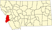
National Register of Historic Places listings in Ravalli County, Montana
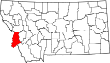
This is a list of the National Register of Historic Places listings in Ravalli County, Montana.
This is intended to be a complete list of the properties and districts on the National Register of Historic Places in Ravalli County, Montana, United States. There are 92 properties and districts listed on the National Register in the county.
This National Park Service list is complete through NPS recent listings posted September 13, 2024.[1]
Map all coordinates using OpenStreetMap
Download coordinates as:
- KML
- GPX (all coordinates)
- GPX (primary coordinates)
- GPX (secondary coordinates)
Current listings
| [2] | Name on the Register | Image | Date listed[3] | Location | City or town | Description |
|---|---|---|---|---|---|---|
| 1 | Allison-Reinkeh House |  | August 26, 1988 (#88001280) | 207 Adirondac St. 46°15′17″N 114°09′29″W / 46.254722°N 114.158056°W / 46.254722; -114.158056 (Allison-Reinkeh House) | Hamilton | part of the Hamilton MRA |
| 2 | Alta Ranger Station |  | December 19, 1974 (#74001099) | South of Conner in the Bitterroot National Forest 45°37′08″N 114°17′55″W / 45.618889°N 114.298611°W / 45.618889; -114.298611 (Alta Ranger Station) | Conner | |
| 3 | Bass Mansion |  | November 14, 1978 (#78001691) | 216 N. College St. 46°30′43″N 114°05′20″W / 46.511944°N 114.088889°W / 46.511944; -114.088889 (Bass Mansion) | Stevensville | |
| 4 | Daniel V. Bean House |  | August 26, 1988 (#88001288) | 611 N. 2nd 46°15′10″N 114°09′27″W / 46.252778°N 114.1575°W / 46.252778; -114.1575 (Daniel V. Bean House) | Hamilton | part of the Hamilton MRA |
| 5 | Big Creek Lake Site | Upload image | May 17, 1976 (#76001127) | Address restricted[4] | Stevensville | |
| 6 | Bitter Root Cooperative Creamery |  | June 19, 1991 (#91000726) | 3730 Eastside Highway 46°30′44″N 114°04′54″W / 46.512222°N 114.081667°W / 46.512222; -114.081667 (Bitter Root Cooperative Creamery) | Stevensville | part of the Stevensville MRA |
| 7 | Oliver Blood House |  | August 26, 1988 (#88001279) | 524 S. 1st St. 46°14′33″N 114°09′13″W / 46.2425°N 114.153611°W / 46.2425; -114.153611 (Oliver Blood House) | Hamilton | part of the Hamilton MRA |
| 8 | Boulder Point Lookout |  | November 10, 1980 (#100002044) | 2 miles (3.2 km) NW of West Fork Ranger Station 45°50′16″N 114°17′21″W / 45.837782°N 114.289085°W / 45.837782; -114.289085 (Boulder Point Lookout) | Darby vicinity | |
| 9 | Brooks Hotel | 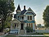 | November 10, 1980 (#80002430) | Off the East Side Highway 46°18′46″N 114°06′44″W / 46.312778°N 114.112222°W / 46.312778; -114.112222 (Brooks Hotel) | Corvallis | |
| 10 | Charles Amos Buck House |  | June 18, 1991 (#91000727) | 211 Buck St. 46°30′37″N 114°05′38″W / 46.510278°N 114.093889°W / 46.510278; -114.093889 (Charles Amos Buck House) | Stevensville | part of the Stevensville MRA |
| 11 | Fred Buck House | 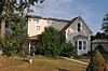 | June 18, 1991 (#91000729) | 217 Buck St. 46°30′36″N 114°05′39″W / 46.51°N 114.094167°W / 46.51; -114.094167 (Fred Buck House) | Stevensville | part of the Stevensville MRA |
| 12 | Canyon Creek Laboratory of the U.S. Public Health Service | 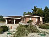 | October 15, 1970 (#70000362) | West of Hamilton city limits 46°15′15″N 114°10′49″W / 46.254167°N 114.180278°W / 46.254167; -114.180278 (Canyon Creek Laboratory of the U.S. Public Health Service) | Hamilton | Altered and now home to the Hamilton Players Theater. |
| 13 | W.T. Caple House | 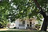 | June 19, 1991 (#91000730) | 210 Church St. 46°30′37″N 114°05′28″W / 46.510278°N 114.091111°W / 46.510278; -114.091111 (W.T. Caple House) | Stevensville | part of the Stevensville MRA |
| 14 | Jennie Clark House |  | June 19, 1991 (#91000731) | 423 Pine St. 46°30′25″N 114°05′21″W / 46.506944°N 114.089167°W / 46.506944; -114.089167 (Jennie Clark House) | Stevensville | part of the Stevensville MRA |
| 15 | William Cochran House |  | June 19, 1991 (#91000732) | 3713 East Side Highway 46°30′46″N 114°05′00″W / 46.512778°N 114.083333°W / 46.512778; -114.083333 (William Cochran House) | Stevensville | part of the Stevensville MRA |
| 16 | Como School |  | November 22, 2022 (#100008424) | Jct. of Old Darby Rd. and US 93 46°05′27″N 114°10′33″W / 46.0907°N 114.1758°W / 46.0907; -114.1758 (Como School) | Darby vicinity | |
| 17 | Conway House |  | August 26, 1988 (#88001291) | 805 S. 4th St. 46°14′20″N 114°09′32″W / 46.238889°N 114.158889°W / 46.238889; -114.158889 (Conway House) | Hamilton | part of the Hamilton MRA |
| 18 | Calvin and Maggie Cook House |  | June 19, 1991 (#91000734) | 501 Main St. 46°30′24″N 114°05′36″W / 46.506667°N 114.093333°W / 46.506667; -114.093333 (Calvin and Maggie Cook House) | Stevensville | part of the Stevensville MRA |
| 19 | Wilbur Cook House |  | June 19, 1991 (#91000733) | 3717 East Side Highway 46°30′46″N 114°04′59″W / 46.512778°N 114.083056°W / 46.512778; -114.083056 (Wilbur Cook House) | Stevensville | part of the Stevensville MRA |
| 20 | Martin Cramer House |  | August 3, 1987 (#87001259) | 326 Groff La. 46°25′32″N 114°04′51″W / 46.425556°N 114.080833°W / 46.425556; -114.080833 (Martin Cramer House) | Stevensville | |
| 21 | Marcus Daly Memorial Hospital |  | December 15, 1978 (#78001690) | 211 S. 4th St. 46°14′43″N 114°09′34″W / 46.245278°N 114.159444°W / 46.245278; -114.159444 (Marcus Daly Memorial Hospital) | Hamilton | |
| 22 | DeNayer House | 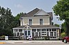 | July 29, 1994 (#94000782) | 327 Main St. 46°30′31″N 114°06′18″W / 46.508611°N 114.105°W / 46.508611; -114.105 (DeNayer House) | Stevensville | part of the Stevensville MRA |
| 23 | F.H. Drinkenberg's First Home |  | August 26, 1988 (#88001289) | 701 N. 2nd 46°15′12″N 114°09′27″W / 46.253333°N 114.1575°W / 46.253333; -114.1575 (F.H. Drinkenberg's First Home) | Hamilton | part of the Hamilton MRA |
| 24 | El Capitan Lodge | 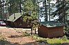 | November 29, 1990 (#90001792) | Access Rd. 1111 on the northern shore of Lake Como in the Bitterroot National Forest 46°03′56″N 114°14′42″W / 46.065556°N 114.245°W / 46.065556; -114.245 (El Capitan Lodge) | Hamilton | |
| 25 | E.G. Ellis House |  | August 26, 1988 (#88001281) | 801 N. 3rd 46°15′17″N 114°09′32″W / 46.254722°N 114.158889°W / 46.254722; -114.158889 (E.G. Ellis House) | Hamilton | part of the Hamilton MRA |
| 26 | Emhoff House |  | June 19, 1991 (#91000736) | 401 Church St. 46°30′29″N 114°05′31″W / 46.508056°N 114.091944°W / 46.508056; -114.091944 (Emhoff House) | Stevensville | part of the Stevensville MRA |
| 27 | Etna School |  | May 30, 1997 (#97000504) | 2853 Eastside Highway 46°25′59″N 114°05′39″W / 46.433056°N 114.094167°W / 46.433056; -114.094167 (Etna School) | Stevensville | |
| 28 | First Baptist Church |  | September 3, 1991 (#91000737) | 402 Church 46°30′29″N 114°05′30″W / 46.508056°N 114.091667°W / 46.508056; -114.091667 (First Baptist Church) | Stevensville | part of the Stevensville MRA |
| 29 | First State Bank, Dowling and Emhoff Buildings |  | June 19, 1991 (#91000738) | 300-304 and 306-308 Main St. 46°30′35″N 114°05′33″W / 46.509722°N 114.0925°W / 46.509722; -114.0925 (First State Bank, Dowling and Emhoff Buildings) | Stevensville | part of the Stevensville MRA |
| 30 | Joseph Fisher House |  | June 19, 1991 (#91000739) | 103 College St. 46°30′43″N 114°05′23″W / 46.511944°N 114.089722°W / 46.511944; -114.089722 (Joseph Fisher House) | Stevensville | part of the Stevensville MRA |
| 31 | Fort Owen |  | October 6, 1970 (#70000363) | About 0.5 miles (0.80 km) northwest of Stevensville 46°31′10″N 114°05′49″W / 46.519444°N 114.097083°W / 46.519444; -114.097083 (Fort Owen) | Stevensville | |
| 32 | Perry Foust House |  | June 19, 1991 (#91000740) | 401 Mission St. 46°30′31″N 114°05′45″W / 46.508611°N 114.095833°W / 46.508611; -114.095833 (Perry Foust House) | Stevensville | part of the Stevensville MRA; demolished. |
| 33 | Foye Rental Houses |  | August 26, 1988 (#88001292) | 819 and 821 N. 4th 46°15′17″N 114°09′38″W / 46.254722°N 114.160556°W / 46.254722; -114.160556 (Foye Rental Houses) | Hamilton | part of the Hamilton MRA |
| 34 | Charles Fulton House | 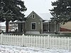 | June 19, 1991 (#91000742) | 377 5th St. 46°30′22″N 114°05′24″W / 46.506111°N 114.09°W / 46.506111; -114.09 (Charles Fulton House) | Stevensville | part of the Stevensville MRA |
| 35 | Gavin House |  | June 19, 1991 (#91000743) | 219 College St. 46°30′35″N 114°05′25″W / 46.509722°N 114.090278°W / 46.509722; -114.090278 (Gavin House) | Stevensville | part of the Stevensville MRA |
| 36 | Sherman Gill House |  | August 26, 1988 (#88001282) | 605 N. 3rd 46°15′07″N 114°09′32″W / 46.251944°N 114.158889°W / 46.251944; -114.158889 (Sherman Gill House) | Hamilton | part of the Hamilton MRA |
| 37 | Gird Point Lookout |  | April 6, 2018 (#100002297) | Gird Pt., Sapphire Mts., Bitterroot NF 46°12′27″N 113°54′42″W / 46.207451°N 113.911538°W / 46.207451; -113.911538 (Gird Point Lookout) | Hamilton vicinity | |
| 38 | Gleason Building |  | June 19, 1991 (#91000744) | 200-202 Main St. 46°30′39″N 114°05′27″W / 46.510833°N 114.090833°W / 46.510833; -114.090833 (Gleason Building) | Stevensville | part of the Stevensville MRA |
| 39 | Goff House |  | August 26, 1988 (#88001283) | 115 N. 5th 46°14′50″N 114°09′39″W / 46.247222°N 114.160833°W / 46.247222; -114.160833 (Goff House) | Hamilton | part of the Hamilton MRA |
| 40 | Gordon House |  | August 26, 1988 (#88001294) | 806 S. 4th 46°14′22″N 114°09′29″W / 46.239444°N 114.158056°W / 46.239444; -114.158056 (Gordon House) | Hamilton | part of the Hamilton MRA |
| 41 | Charles Granke House |  | August 26, 1988 (#88001278) | 406 S. 7th St. 46°14′36″N 114°09′45″W / 46.243333°N 114.1625°W / 46.243333; -114.1625 (Charles Granke House) | Hamilton | part of the Hamilton MRA |
| 42 | Hamilton Commercial Historic District |  | September 1, 1988 (#88001273) | Main, N. 2nd, S. 2nd, S. 3rd, and State Sts. 46°14′50″N 114°09′27″W / 46.247222°N 114.1575°W / 46.247222; -114.1575 (Hamilton Commercial Historic District) | Hamilton | part of the Hamilton MRA |
| 43 | Hamilton Southside Residential Historic District |  | September 1, 1988 (#88001272) | S. 1st, S. 2nd, S. 3rd, S. 4th, and S. 5th Sts. 46°14′35″N 114°09′27″W / 46.243056°N 114.1575°W / 46.243056; -114.1575 (Hamilton Southside Residential Historic District) | Hamilton | part of the Hamilton MRA |
| 44 | Hamilton Town Hall |  | April 21, 1980 (#80002431) | 175 S. 3rd St. 46°14′46″N 114°09′29″W / 46.246111°N 114.158056°W / 46.246111; -114.158056 (Hamilton Town Hall) | Hamilton | Not the current city hall. |
| 45 | Rose Harrington House |  | June 19, 1991 (#91000745) | 3709 East Side Highway 46°30′46″N 114°05′00″W / 46.512778°N 114.083333°W / 46.512778; -114.083333 (Rose Harrington House) | Stevensville | part of the Stevensville MRA |
| 46 | Hayward Lodge |  | May 11, 2015 (#15000216) | On L. Como 46°03′55″N 114°14′41″W / 46.0654°N 114.2446°W / 46.0654; -114.2446 (Hayward Lodge) | Bitterroot National Forest, Darby vicinity | Now known as Wood's Cabin. |
| 47 | Charles Hoffman House |  | August 26, 1988 (#88001277) | 807 S. 3rd 46°14′20″N 114°09′23″W / 46.238889°N 114.156389°W / 46.238889; -114.156389 (Charles Hoffman House) | Hamilton | part of the Hamilton MRA |
| 48 | John G. Howe House |  | June 18, 1991 (#91000746) | 215 Park Ave. 46°30′27″N 114°05′05″W / 46.5075°N 114.084722°W / 46.5075; -114.084722 (John G. Howe House) | Stevensville | part of the Stevensville MRA |
| 49 | IOOF Hall | 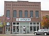 | June 19, 1991 (#91000747) | 217-219 Main St. 46°30′37″N 114°05′35″W / 46.510278°N 114.093056°W / 46.510278; -114.093056 (IOOF Hall) | Stevensville | part of the Stevensville MRA |
| 50 | John Lagerquist House |  | August 26, 1988 (#88001284) | 701 N. 4th St. 46°15′12″N 114°09′37″W / 46.253333°N 114.160278°W / 46.253333; -114.160278 (John Lagerquist House) | Hamilton | part of the Hamilton MRA |
| 51 | Lancaster House |  | June 19, 1991 (#91000748) | 407 3rd St. 46°30′33″N 114°05′16″W / 46.509167°N 114.087778°W / 46.509167; -114.087778 (Lancaster House) | Stevensville | part of the Stevensville MRA |
| 52 | John A. Landram House | 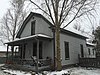 | March 14, 1996 (#91000749) | 113 College St. 46°30′42″N 114°05′11″W / 46.511667°N 114.086389°W / 46.511667; -114.086389 (John A. Landram House) | Stevensville | part of the Stevensville MRA |
| 53 | Lockridge House |  | June 19, 1991 (#91000750) | 301 Mission St. 46°30′35″N 114°04′57″W / 46.509722°N 114.0825°W / 46.509722; -114.0825 (Lockridge House) | Stevensville | part of the Stevensville MRA |
| 54 | Lost Horse Fireman's Cabin (24RA197) | Upload image | April 17, 1989 (#88003437) | Off Lost Horse Rd. near Bear Creek Pass 46°07′50″N 114°29′33″W / 46.130556°N 114.4925°W / 46.130556; -114.4925 (Lost Horse Fireman's Cabin (24RA197)) | Darby | |
| 55 | Albert May House | 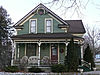 | June 18, 1991 (#91000751) | 218 Church St. 46°30′36″N 114°05′27″W / 46.51°N 114.090833°W / 46.51; -114.090833 (Albert May House) | Stevensville | part of the Stevensville MRA |
| 56 | Charles May House | 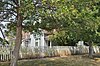 | June 18, 1991 (#91000753) | 109 Church St. 46°30′43″N 114°05′28″W / 46.511944°N 114.091111°W / 46.511944; -114.091111 (Charles May House) | Stevensville | part of the Stevensville MRA |
| 57 | George May House |  | October 25, 1982 (#82000596) | 100 Park Ave. 46°30′32″N 114°05′01″W / 46.508889°N 114.083611°W / 46.508889; -114.083611 (George May House) | Stevensville | |
| 58 | Harry May House |  | June 18, 1991 (#91000752) | 526 3rd St. 46°30′34″N 114°05′04″W / 46.509444°N 114.084444°W / 46.509444; -114.084444 (Harry May House) | Stevensville | part of the Stevensville MRA |
| 59 | Louis May House | 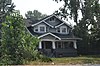 | June 19, 1991 (#91000754) | 100 Church St. 46°30′44″N 114°05′26″W / 46.512222°N 114.090556°W / 46.512222; -114.090556 (Louis May House) | Stevensville | part of the Stevensville MRA |
| 60 | McCart Fire Lookout | Upload image | June 19, 1996 (#96000660) | Approximately 4 miles (6.4 km) south of the East Fork Forest Service Station in Bitterroot National Forest 45°53′05″N 113°43′00″W / 45.884722°N 113.716667°W / 45.884722; -113.716667 (McCart Fire Lookout) | Sula | |
| 61 | James McCrossin Cabin | 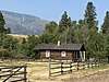 | December 2, 2019 (#100004710) | 1237 MT 93 S. Coordinates missing | Hamilton vicinity | |
| 62 | McFarlane House | 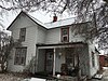 | June 19, 1991 (#91000755) | 200 College St. 46°30′39″N 114°05′22″W / 46.510833°N 114.089444°W / 46.510833; -114.089444 (McFarlane House) | Stevensville | part of the Stevensville MRA |
| 63 | McGlauflin House |  | August 26, 1988 (#88001276) | 518 S. 8th 46°14′31″N 114°09′50″W / 46.241944°N 114.163889°W / 46.241944; -114.163889 (McGlauflin House) | Hamilton | part of the Hamilton MRA |
| 64 | John McLaughlin House |  | June 19, 1991 (#91000757) | 105 Main St. 46°30′44″N 114°05′35″W / 46.512222°N 114.093056°W / 46.512222; -114.093056 (John McLaughlin House) | Stevensville | part of the Stevensville MRA; demolished |
| 65 | Medicine Point Lookout | Upload image | April 6, 2018 (#100002298) | Medicine Pt., Sula Ranger Dist., Bitterroot NF 45°48′25″N 114°06′37″W / 45.806942°N 114.110202°W / 45.806942; -114.110202 (Medicine Point Lookout) | Darby vicinity | |
| 66 | Metcalf House |  | June 19, 1991 (#91000758) | 214 Pine St. 46°30′34″N 114°04′55″W / 46.509444°N 114.081944°W / 46.509444; -114.081944 (Metcalf House) | Stevensville | part of the Stevensville MRA |
| 67 | Methodist Episcopal Church South |  | November 24, 1997 (#97001453) | Junction of 1st St. and the Eastside Highway 46°18′57″N 114°06′48″W / 46.315833°N 114.113333°W / 46.315833; -114.113333 (Methodist Episcopal Church South) | Corvallis | |
| 68 | Philip and Ella Morr House |  | June 19, 1991 (#91000760) | 502 Buck St. 46°30′24″N 114°05′41″W / 46.506667°N 114.094722°W / 46.506667; -114.094722 (Philip and Ella Morr House) | Stevensville | part of the Stevensville MRA |
| 69 | Pine Apartments | 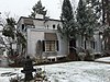 | August 26, 1988 (#88001295) | 804 S. 4th St. 46°14′20″N 114°09′29″W / 46.238889°N 114.158056°W / 46.238889; -114.158056 (Pine Apartments) | Hamilton | part of the Hamilton MRA |
| 70 | Popham Ranch | 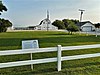 | January 13, 1989 (#88003141) | 460 NE. Popham Ln. 46°20′45″N 114°05′29″W / 46.345833°N 114.091389°W / 46.345833; -114.091389 (Popham Ranch) | Corvallis | |
| 71 | Ravalli County Courthouse |  | April 20, 1979 (#79001424) | 225 Bedford St. 46°14′40″N 114°09′26″W / 46.244444°N 114.157222°W / 46.244444; -114.157222 (Ravalli County Courthouse) | Hamilton | The old courthouse, now a local history museum |
| 72 | Riverside | 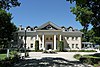 | July 16, 1987 (#87001235) | 251 Eastside Highway[5] 46°15′57″N 114°08′20″W / 46.265833°N 114.138889°W / 46.265833; -114.138889 (Riverside) | Hamilton | Once the home of Marcus Daly[6] |
| 73 | Rocky Mountain Laboratory Historic District |  | September 1, 1988 (#88001274) | 900 block of 4th St. 46°14′14″N 114°09′29″W / 46.237222°N 114.158056°W / 46.237222; -114.158056 (Rocky Mountain Laboratory Historic District) | Hamilton | part of the Hamilton MRA |
| 74 | St. Mary's Church and Pharmacy | 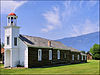 | October 6, 1970 (#70000364) | North Ave. • St. Mary's Mission Historic District boundary increase (listed August 16, 2010, refnum 10000552): West end of 4th St. 46°30′29″N 114°05′43″W / 46.508056°N 114.095278°W / 46.508056; -114.095278 (St. Mary's Church and Pharmacy) | Stevensville | |
| 75 | St. Mary Peak Lookout | 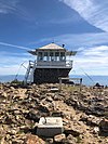 | April 6, 2018 (#100002299) | Saint Mary Peak, Stevensville Ranger Dist., Bitterroot NF 46°30′42″N 114°14′37″W / 46.511779°N 114.243741°W / 46.511779; -114.243741 (St. Mary Peak Lookout) | Stevensville vicinity | |
| 76 | John Sharp House |  | June 19, 1991 (#91000761) | 306 College St. 46°30′33″N 114°05′22″W / 46.509167°N 114.089444°W / 46.509167; -114.089444 (John Sharp House) | Stevensville | part of the Stevensville MRA |
| 77 | Stevensville Feed Mill |  | June 19, 1991 (#91000762) | 407 Main St. 46°30′29″N 114°05′36″W / 46.508056°N 114.093333°W / 46.508056; -114.093333 (Stevensville Feed Mill) | Stevensville | part of the Stevensville MRA |
| 78 | Stevensville Grade School-United Methodist Church |  | June 19, 1991 (#91000764) | 216 College St. 46°30′36″N 114°05′22″W / 46.51°N 114.089444°W / 46.51; -114.089444 (Stevensville Grade School-United Methodist Church) | Stevensville | part of the Stevensville MRA |
| 79 | Stevensville Mercantile Company Oil Storage Building | 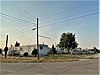 | June 19, 1991 (#91000763) | 300 Mission St. 46°30′36″N 114°05′43″W / 46.51°N 114.095278°W / 46.51; -114.095278 (Stevensville Mercantile Company Oil Storage Building) | Stevensville | part of the Stevensville MRA; demolished |
| 80 | John Stout House | 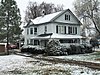 | August 26, 1988 (#88001290) | 1000 S. 1st 46°14′13″N 114°09′11″W / 46.236944°N 114.153056°W / 46.236944; -114.153056 (John Stout House) | Hamilton | part of the Hamilton MRA |
| 81 | Summers-Quast Farmstead |  | December 30, 1997 (#97001590) | 1288 Eastside Highway 46°19′39″N 114°06′45″W / 46.3275°N 114.1125°W / 46.3275; -114.1125 (Summers-Quast Farmstead) | Corvallis | |
| 82 | Thornton Hospital |  | June 19, 1991 (#91000765) | 107 E. 3rd St. 46°30′35″N 114°06′17″W / 46.509722°N 114.104722°W / 46.509722; -114.104722 (Thornton Hospital) | Stevensville | part of the Stevensville MRA |
| 83 | Erick Trosdahl House |  | August 26, 1988 (#88001275) | 206 S. 7th St. 46°14′43″N 114°09′46″W / 46.245278°N 114.162778°W / 46.245278; -114.162778 (Erick Trosdahl House) | Hamilton | part of the Hamilton MRA |
| 84 | University Heights Historic District | Upload image | August 14, 2012 (#12000501) | 469 Bunkhouse Creek Rd. 46°01′50″N 114°13′05″W / 46.030685°N 114.217991°W / 46.030685; -114.217991 (University Heights Historic District) | Darby vicinity | |
| 85 | VFW Club | 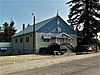 | August 26, 1988 (#88001287) | 930 Adirondac 46°15′18″N 114°10′16″W / 46.255°N 114.171111°W / 46.255; -114.171111 (VFW Club) | Hamilton | part of the Hamilton MRA |
| 86 | Frank Wallin House |  | August 26, 1988 (#88001293) | 608 N. 7th St. 46°15′08″N 114°09′51″W / 46.252222°N 114.164167°W / 46.252222; -114.164167 (Frank Wallin House) | Hamilton | part of the Hamilton MRA |
| 87 | Other C. Wamsley House |  | August 26, 1988 (#88001285) | 200 N. 5th St. 46°14′54″N 114°09′37″W / 46.248333°N 114.160278°W / 46.248333; -114.160278 (Other C. Wamsley House) | Hamilton | part of the Hamilton MRA |
| 88 | West Fork Ranger Station |  | July 18, 2023 (#100009135) | 6735 West Fork Rd. 45°48′58″N 114°15′30″W / 45.8160°N 114.2583°W / 45.8160; -114.2583 (West Fork Ranger Station) | Darby vicinity | |
| 89 | Whaley Homestead | 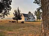 | March 26, 1992 (#91000442) | Wildfowl Rd. west of the East Side Highway in the Lee Metcalf National Wildlife Refuge 46°33′03″N 114°04′36″W / 46.550833°N 114.076667°W / 46.550833; -114.076667 (Whaley Homestead) | Stevensville | |
| 90 | Williams House | 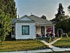 | June 19, 1991 (#91000766) | 500 5th St. 46°30′23″N 114°05′11″W / 46.506389°N 114.086389°W / 46.506389; -114.086389 (Williams House) | Stevensville | part of the Stevensville MRA |
| 91 | John and Ann Williams House | 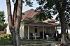 | June 19, 1991 (#91000735) | 205 Church St. 46°30′37″N 114°05′29″W / 46.510278°N 114.091389°W / 46.510278; -114.091389 (John and Ann Williams House) | Stevensville | part of the Stevensville MRA |
| 92 | Benjamin Young House |  | June 19, 1991 (#91000741) | 523 Main St. 46°30′18″N 114°05′33″W / 46.505°N 114.0925°W / 46.505; -114.0925 (Benjamin Young House) | Stevensville | part of the Stevensville MRA |
See also
Wikimedia Commons has media related to National Register of Historic Places in Ravalli County, Montana.
- List of National Historic Landmarks in Montana
- National Register of Historic Places listings in Montana
References
- ^ National Park Service, United States Department of the Interior, "National Register of Historic Places: Weekly List Actions", retrieved September 13, 2024.
- ^ Numbers represent an alphabetical ordering by significant words. Various colorings, defined here, differentiate National Historic Landmarks and historic districts from other NRHP buildings, structures, sites or objects.
- ^ The eight-digit number below each date is the number assigned to each location in the National Register Information System database, which can be viewed by clicking the number.
- ^ Federal and state laws and practices restrict general public access to information regarding the specific location of this resource. In some cases, this is to protect archeological sites from vandalism, while in other cases it is restricted at the request of the owner. See: Knoerl, John; Miller, Diane; Shrimpton, Rebecca H. (1990), Guidelines for Restricting Information about Historic and Prehistoric Resources, National Register Bulletin, National Park Service, U.S. Department of the Interior, OCLC 20706997.
- ^ Street address derived from the house website; the NRIS gives only "Eastside Highway"
- ^ The historic estate of copper king Marcus Daly, Daly Mansion, 2005. Accessed 2009-04-04.
- v
- t
- e
- Beaverhead
- Big Horn
- Blaine
- Broadwater
- Carbon
- Carter
- Cascade
- Chouteau
- Custer
- Daniels
- Dawson
- Deer Lodge
- Fallon
- Fergus
- Flathead
- Gallatin
- Garfield
- Glacier
- Golden Valley
- Granite
- Hill
- Jefferson
- Judith Basin
- Lake
- Lewis and Clark
- Liberty
- Lincoln
- Madison
- McCone
- Meagher
- Mineral
- Missoula
- Musselshell
- Park
- Petroleum
- Phillips
- Pondera
- Powder River
- Powell
- Prairie
- Ravalli
- Richland
- Roosevelt
- Rosebud
- Sanders
- Sheridan
- Silver Bow
- Stillwater
- Sweet Grass
- Teton
- Toole
- Treasure
- Valley
- Wheatland
- Wibaux
- Yellowstone

- Bridges
- Historic districts
- Houses
- National Historic Landmarks
- Properties of religious function
- Railway stations