Newmarket Industrial and Commercial Historic District
Historic district in New Hampshire, United States
United States historic place
Newmarket Industrial and Commercial Historic District | |
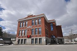 Newmarket Town Hall | |
43°4′47″N 70°56′14″W / 43.07972°N 70.93722°W / 43.07972; -70.93722 | |
| Area | 10 acres (4.0 ha) |
|---|---|
| Architectural style | Greek Revival, Late Victorian, Federal |
| NRHP reference No. | 80000302[1] |
| Added to NRHP | December 1, 1980 |
The Newmarket Industrial and Commercial Historic District encompasses the heart of a distinctive 19th century mill town, Newmarket, New Hampshire. Its mill complex is regionally distinctive for its extensive use of stone from an early date, and the town is relatively well-preserved due to a significant economic decline after the mills closed in 1920. The district was listed on the National Register of Historic Places in 1980.[1] The Stone School, listed in 1978, is a contributing resource.[2]
Description and history
The town of Newmarket was incorporated in 1737, and was initially a shipping center, based on the Lamprey River, a tributary of the Piscataqua River. In the early 19th century, the power of the Lamprey River was harnessed by textile manufacturing businesses, which fueled the community's growth into the early 20th century. That industry then declined, leaving a distinctive architectural legacy in New Hampshire's Seacoast Region. The most notable aspects of the town's buildings is the use of stone, in contrast to other mill towns of southern New England, which predominantly used brick. The use of stone was not limited to the mills themselves: the historic district also has examples of stone houses, churches, and schools.[2]
The historic district extends along Main Street (New Hampshire Route 108) between Gerry Street and Elm Street, Exeter between Gerry and Main, Nichols and Central streets, and a number of smaller adjacent streets between Main Street and Granite and Spring streets. Its principal eastern boundary is the Lamprey River, along which the surviving mill buildings are arrayed. Commercial buildings are mainly located across Main Street from the mills, with residential housing on side streets. A cluster of town buildings and a church are located at the junction of South Main Street and Beech Street Extension. The town hall is a handsome Greek Revival brick building constructed in 1847.[2]
See also
References
- ^ a b "National Register Information System". National Register of Historic Places. National Park Service. July 9, 2010.
- ^ a b c "NRHP nomination for Newmarket Industrial and Commercial Historic District". National Park Service. Retrieved July 11, 2014.
Wikimedia Commons has media related to Newmarket Industrial and Commercial Historic District.
- v
- t
- e
- Gov. John Langdon Mansion
- John Paul Jones House
- Josiah Bartlett House
- Ladd-Gilman House
- MacPheadris–Warner House
- Matthew Thornton House
- Moffatt-Ladd House
- Richard Jackson House
- Robert Frost Farm
- USS Albacore
- Wentworth–Coolidge Mansion
- Wentworth-Gardner House

- Atlantic Heights Development
- Deerfield Center Historic District
- East Derry Historic District
- Exeter Waterfront Commercial Historic District
- Front Street Historic District
- Highland Road Historic District
- Isles of Shoals‡
- Jewell Town District
- Little Boar's Head Historic District
- Newington Center Historic District
- Newmarket Industrial and Commercial Historic District
- Old Deerfield Center Historic District
- Portsmouth Downtown Historic District
- Portsmouth Parade Historic District
- Richman Margeson Estate
- Salem Common Historic District
- Scammon Farm Historic District
- Smith's Corner Historic District
- Strawbery Banke Historic District
- Town Center Historic District
- Wentworth-Gardner and Tobias Lear Houses
- Woodman Road Historic District
- Fort Constitution
- Old North Cemetery
- Plains Cemetery
‡ This entry also has portions in an adjacent state.
† This entry has been removed from the registry.
† This entry has been removed from the registry.


