Nova Odesa
City in Mykolaiv Oblast, Ukraine
Place in Mykolaiv Oblast, Ukraine
Nova Odesa Нова Одеса | |
|---|---|
 | |
 Flag | |
47°18′35″N 31°46′45″E / 47.30972°N 31.77917°E / 47.30972; 31.77917 | |
| Country |  Ukraine Ukraine |
| Oblast | Mykolaiv Oblast |
| Raion | Mykolaiv Raion |
| Hromada | Nova Odesa urban hromada |
| Founded | 1776 |
| City rights | 1976 |
| Government | |
| • Mayor | Oleksandr Polyakov |
| Area | |
| • Total | 20.65 km2 (7.97 sq mi) |
| Elevation | 15 m (49 ft) |
| Population (2022)[1] | |
| • Total | 11,510 |
| • Density | 560/km2 (1,400/sq mi) |
| Postal code | 55600-56608 |
| Area code | +380-5167 |
Nova Odesa (Ukrainian: Нова Одеса, lit. 'New Odesa', pronounced [noˈwɑ oˈdɛsɐ]) is a city in Mykolaiv Raion, Mykolaiv Oblast (region) of southern Ukraine. It hosts the administration of Nova Odesa urban hromada, one of the hromadas of Ukraine.[2] The population of Nova Odesa is 11,510 (2022 estimate).[1]
Until 18 July 2020, Nova Odesa was the administrative center of Nova Odesa Raion. In July 2020, as part of the administrative reform of Ukraine, which reduced the number of raions of Mykolaiv Oblast to four, Nova Odesa Raion was merged into Mykolaiv Raion.[3][4]
Demographics
As of the 2001 Ukrainian census, the town had a population of 14,073 inhabitants. The ethnic and linguistic composition was as follows:[5][6]
| ||||||||||||||||||||||||||||||||||||||||
| ||||||||||||||||||||||||||||||||||||||||
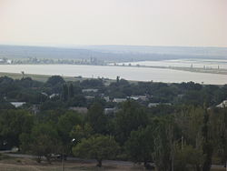
Gallery
-
 City hall
 -
 Grain storage facilities
 -
 World War II memorial
 -
 Soviet–Afghan War memorial
 -
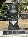 Holocaust memorial


References
- ^ a b Чисельність наявного населення України на 1 січня 2022 [Number of Present Population of Ukraine, as of January 1, 2022] (PDF) (in Ukrainian and English). Kyiv: State Statistics Service of Ukraine. Archived (PDF) from the original on 4 July 2022.
- ^ "Новоодесская городская громада" (in Russian). Портал об'єднаних громад України.
- ^ "Про утворення та ліквідацію районів. Постанова Верховної Ради України № 807-ІХ". Голос України (in Ukrainian). 2020-07-18. Retrieved 2020-10-03.
- ^ "Нові райони: карти + склад" (in Ukrainian). Міністерство розвитку громад та територій України.
- ^ "Всеукраїнський перепис населення 2001" [All-Ukrainian population census 2001]. 2001.ukrcensus.gov.ua (in Ukrainian). Retrieved 2024-07-11.
- ^ "Національний склад міст". Datatowel.in.ua (in Ukrainian). Retrieved 2024-07-11.
External links
- The murder of the Jews of Nova Odesa during World War II, at Yad Vashem website.
- v
- t
- e
- Arbuzynka
- Bashtanka
- Berezanka
- Bereznehuvate
- Blahodatne
- Bratske
- Buzke
- Chornomorka
- Domanivka
- Doroshivka
- Halytsynove
- Horokhivske
- Inhulka
- Kamianyi Mist
- Kazanka
- Kobleve
- Kostiantynivka
- Kryve Ozero
- Kutsurub
- Mishkovo-Pohorilove
- Mostove
- Myhiia
- Mykolaiv
- Nechaiane
- Nova Odesa
- Novomaryivka
- Novyi Buh
- Ochakiv
- Oleksandrivka
- Olshanske
- Pervomaisk
- Pervomaiske
- Prybuzhany
- Prybuzhzhia
- Pryvilne
- Radsadivska
- Shevchenkove
- Shyroke
- Snihurivka
- Sofiivka
- Stepove
- Sukhyi Yelanets
- Syniukhyn Brid
- Veselynove
- Vesniane
- Vilne Zaporizhzhia
- Volodymyrivka
- Voskresenske
- Voznesensk
- Vradiivka
- Yelanets
- Yuzhnoukrainsk
| Authority control databases: National |
|
|---|


