Outer Holm of Skaw
60°23′21″N 0°54′20″W / 60.389079°N 0.905512°W / 60.389079; -0.905512


Outer Holm of Skaw

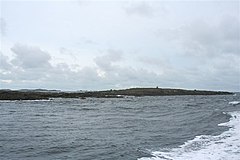
The Outer Holm of Skaw is a small, uninhabited islet, a rock outlier off the northeast coast of the island of Whalsay, in the Shetland Islands of Scotland.[2]
Location
The Outer Holm of Skaw is 14 feet (4.3 m) high, and is about 0.5 miles (0.80 km) to the north of Skaw Taing on the island of Whalsey. The 32 feet (9.8 m) high Inner Holm of Skaw lies between the Outer Holm of Skaw and Whalsey.[1]
Gallery
-
 Outer Holm of Skaw
 -
 Outer Holm of Skaw


References
Citations
- ^ a b United States. Hydrographic Office 1950, p. 311.
- ^ Munro & Gittings 2006, p. 370.
Sources
- Munro, David M.; Gittings, Bruce M. (2006). Scotland: an encyclopedia of places & landscapes. Collins. p. 370. ISBN 978-0-00-472466-9. Retrieved 4 February 2013.
- United States. Hydrographic Office (1950). Sailing directions for the north and east coasts of Scotland: Cape Wrath to Fife Ness and including the Orkney, Shetland and Faeroe Islands. U.S. Govt. Print. Off. Retrieved 4 February 2013.
Wikimedia Commons has media related to Outer Holm of Skaw.
- v
- t
- e
Whalsay

- Bays, cliffs, and headlands: List of coastal features of Whalsay
- Linga Sound
- Islets: East Linga
- Holm of Sandwick
- Inner Holm of Skaw
- Isbister Holm
- Mooa
- Nista
- Outer Holm of Skaw
- Rumble
- Skate of Marrister
- West Linga
- Hills: Setter Hill
- Lochs: Little Water
- Loch of Houll
- Loch of Huxter
- Loch of Isbister
- Loch of Livister
- Loch of Sandwick
- Loch of Stanefield
- Loch of Vats-houll
- Nuckro Water
- East Loch of Skaw
- West Loch of Skaw
- Streams: Breiwick Burn
- Falsa Burn
- Scarfmoor Burn
 | This Shetland location article is a stub. You can help Wikipedia by expanding it. |
- v
- t
- e


