Peveril Peak
Mountain in the country of Canada


Peveril Peak
Location of Peveril Peak in Alberta
Show map of Alberta
Peveril Peak
Peveril Peak (Canada)
Show map of CanadaCanadian Rockies
Peveril Peak is a 2,686-metre (8,812-foot) mountain summit located in Alberta, Canada.
Description
Peveril Peak is set within Jasper National Park, in the Trident Range of the Canadian Rockies. The town of Jasper is situated 14 kilometres (8.7 mi) to the north and the Continental Divide is 13 kilometres (8.1 mi) to the west. The nearest higher neighbor is Terminal Mountain, 2.57 km (1.60 mi) to the north.[2] The peak is visible from the Icefields Parkway to the east.[4] Precipitation runoff from Peveril Peak drains into Portal Creek, a tributary of the Athabasca River. Topographic relief is significant as the summit rises 850 meters (2,790 feet) above the creek in one kilometer (0.6 mile).
History
The summit was first reached in 1926 by Bradley B. Gilman and his crew, who called it "Portal Peak."[1][5] The peak was named in 1932 after Sir Walter Scott's 1823 novel Peveril of the Peak, and in turn the title refers to Peveril Castle.[1][4] The mountain's toponym was officially adopted February 7, 1951, by the Geographical Names Board of Canada.[3]
Climate
Based on the Köppen climate classification, Peveril Peak is located in a subarctic climate zone with cold, snowy winters, and mild summers.[6] Winter temperatures can drop below -20 °C with wind chill factors below -30 °C.
Geology
The mountain is composed of sedimentary rock laid down during the Precambrian to Jurassic periods and pushed east and over the top of younger rock during the Laramide orogeny.[7]
See also
 Mountains portal
- Geography of Alberta

Gallery
-
-

-

-
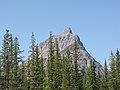
 South aspect
 -
 Peveril Peak (centered) with Oldhorn Mountain (behind, right) viewed from The Whistlers.


References
- ^ a b c Glen W. Boles, William Lowell Putnam, Roger W. Laurilla (2006), "Canadian Mountain Place Names", Rocky Mountain Books, ISBN 9781894765794, p. 199.
- ^ a b c d "Peveril Peak, Peakvisor.com". Retrieved 2023-02-01.
- ^ a b "Peveril Peak". Geographical Names Data Base. Natural Resources Canada. Retrieved 2023-02-01.
- ^ a b "Peveril Peak". cdnrockiesdatabases.ca. Retrieved 2023-02-01.
- ^ The American Alpine News Issues 176-199 (1986), American Alpine Club, p. 17.
- ^ Peel, M. C.; Finlayson, B. L.; McMahon, T. A. (2007). "Updated world map of the Köppen−Geiger climate classification". Hydrol. Earth Syst. Sci. 11: 1633–1644. ISSN 1027-5606.
- ^ Gadd, Ben (2008), Geology of the Rocky Mountains and Columbias
External links
- Parks Canada web site: Jasper National Park
- Peveril Peak: weather forecast
- Climbing Peveril Peak: Giantsgate.com
- Bradley Baldwin Gilman in memoriam: Americanalpineclub.org
Places adjacent to Peveril Peak | ||||||||||||||||
|---|---|---|---|---|---|---|---|---|---|---|---|---|---|---|---|---|
| ||||||||||||||||


- v
- t
- e
- Ball
- Bare
- Beaverfoot
- Blue
- Bow
- Crowsnest
- Elk
- Fairholme
- Fiddle
- Flathead
- Foothills
- High Rock
- Kananaskis
- Livingstone
- Lizard
- Maligne
- Massive
- Misty
- Morrissey
- Palliser
- President
- Queen Elizabeth
- Rainbow
- Ram
- Sawback
- Sentinel
- Slate
- South Jasper
- Sundance
- Terminal
- Tower of London
- Vermilion
- Victoria Cross
- Waputik
- Winston Churchill
- Continental Ranges
- Hart Ranges
- Muskwa Ranges
- Alberta
- Andromeda
- Assiniboine
- Athabasca
- Brazeau
- Bryce
- Cascade
- Castle
- Castleguard
- Clemenceau
- Columbia
- Cory
- Edith Cavell
- Forbes
- Hector
- Hosmer
- Hungabee
- Joffre
- Kitchener
- Lyell
- Heart
- Pilot
- Pyramid
- Resplendent
- Robson
- Rundle
- Sarbach
- Saskatchewan
- Smythe
- Snow Dome
- Stanley Peak
- Sulphur
- Temple
- Three Sisters
- Trinity
- Twin
- Ulysses
- Unnamed Alberta–BC mountain (formerly Mount Pétain)
- Whymper
see List of rivers of the Canadian Rockies and Category:Rivers of the Canadian Rockies
- Mountain Stoney
- Mountain Metis
| International | |
|---|---|
| National |
|
| Provincial (AB) |
|
| Provincial (BC) |
- See also
- Geography portal
- Canada portal


