Pisang
Village development committee in Gandaki, Nepal
Pisang पिसाङ | |
|---|---|
Village development committee | |
 Pisang | |
28°37′00″N 84°09′00″E / 28.61673°N 84.14991°E / 28.61673; 84.14991 | |
| Country |  Nepal Nepal |
| Zone | Gandaki |
| District | Manang |
| Elevation | 3,250 m (10,660 ft) |
| Population (2011)[1] | |
| • Total | 307 |
| Time zone | UTC+5:45 (Nepal Time) |

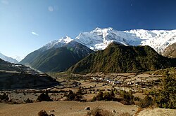
Pisang is a village development committee in Manang District in the Gandaki Zone of northern Nepal. At the time of the 2011 Nepal census it had a population of 307 people living in 105 individual households. The village is located in the Marshyangdi River valley, directly south of Pisang Peak, north of Annapurna II, and west of Paungda Danda. Pisang village is the last human settlement before the Pisang Trekking Peak 6,091 m (19,984 ft), thus increasing tourism activities in the last few years. Currently, 8 local houses have been converted to guest houses to accommodate climbers to Pisang Trek. [2]
References
- ^ "National Population and Housing Census 2011(Village Development Committee/Municipality)" (PDF). Government of Nepal. National Planning Commission. November 2012. Archived from the original (PDF) on 2018-10-05. Retrieved 2017-01-18.
- ^ Makalu, Adventure. "Pisang". Pisang.
- v
- t
- e
Manang District
Headquarters: Chame Rural Municipality
- Chame
- Nason
- Narpa Bhumi
- Nesyang

 | This article about a location in the Manang District of Nepal is a stub. You can help Wikipedia by expanding it. |
- v
- t
- e


