Puerto Rico Highway 117
Highway in Puerto Rico
Major junctions
 PR-315 in Sabana Yeguas–Lajas
 PR-321 in Lajas Arriba–Santa Rosa
 PR-118 / PR-322 in Lajas Arriba
 PR-329 in Plata–Lajas Arriba
 PR-327 in Plata
 PR-328 in Rayo
 PR-2 in Rayo
 PR-121 in Rayo–Machuchal
←  PR-116 PR-116 | →  PR-118 PR-118 |
Puerto Rico Highway 117 (PR-117) is a rural road that travels from Lajas, Puerto Rico to Sabana Grande.[2] It begins at its junction with PR-116 and PR-315 south of downtown Lajas and ends at its intersection with PR-121 in southern Sabana Grande.[3]
Major intersections
-
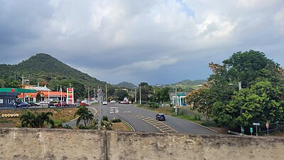 PR-117 east at PR-2 interchange in Rayo, Sabana Grande
 -
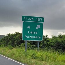 PR-2 west at exit 187 to PR-117 in Rayo, Sabana Grande


| Municipality | Location | km[1] | mi | Destinations | Notes |
|---|---|---|---|---|---|
| Lajas | Sabana Yeguas–Lajas line | 0.0 | 0.0 |   PR-315 to PR-116 (Avenida Manuel "Pito" Pagán Ramírez) – Lajas, Guánica PR-315 to PR-116 (Avenida Manuel "Pito" Pagán Ramírez) – Lajas, Guánica | Western terminus of PR-117 |
| Lajas Arriba–Santa Rosa line | 2.8 | 1.7 |  PR-321 – Santa Rosa PR-321 – Santa Rosa | ||
| Lajas Arriba | 5.4 | 3.4 |   PR-118 / PR-322 – San Germán, Lajas Arriba PR-118 / PR-322 – San Germán, Lajas Arriba | ||
| Plata–Lajas Arriba line | 7.7 | 4.8 |  PR-329 – Minillas PR-329 – Minillas | ||
| Plata | 9.1 | 5.7 |  PR-327 – Plata PR-327 – Plata | ||
| Sabana Grande | Rayo | 11.1 | 6.9 |  PR-328 – Rayo PR-328 – Rayo | |
| 12.9– 13.0 | 8.0– 8.1 |  PR-2 (Expreso Roberto Sánchez Vilella) – Mayagüez, Ponce PR-2 (Expreso Roberto Sánchez Vilella) – Mayagüez, Ponce | PR-2 exit 187; diamond interchange | ||
| Rayo–Machuchal line | 13.1 | 8.1 | PR-121 – Sabana Grande, Yauco | Eastern terminus of PR-117 | |
| 1.000 mi = 1.609 km; 1.000 km = 0.621 mi | |||||
See also
 Puerto Rico portal
 U.S. Roads portal

References
- ^ a b Google (2 March 2020). "PR-117" (Map). Google Maps. Google. Retrieved 2 March 2020.
- ^ National Geographic Maps (2011). Puerto Rico (Map). 1:125,000. Adventure Map (Book 3107). Evergreen, Colorado: National Geographic Maps. ISBN 978-1566955188. OCLC 756511572.
- ^ "Tránsito Promedio Diario (AADT)". Transit Data (Datos de Transito) (in Spanish). DTOP PR. p. 67. Archived from the original on 1 April 2019.
External links
 Media related to Puerto Rico Highway 117 at Wikimedia Commons
- v
- t
- e


