Puerto Rico Highway 35
Highway in Puerto Rico
Major junctions
 PR-1 in Santurce
 PR-37 in Santurce
 PR-22 in Santurce
 PR-2 in Santurce
 PR-39 in Santurce
 PR-16 in Santurce
←  PR-34 PR-34 | →  PR-36 PR-36 |
Puerto Rico Highway 35 (PR-35), also known as Avenida Manuel Fernández Juncos, is an urban road in San Juan, Puerto Rico.[2]
Route description
It begins at Miramar, from the intersection of PR-1 (Expreso Luis Muñoz Rivera) and PR-26 (Expreso Román Baldorioty de Castro) to the PR-1 (Avenida Luis Muñoz Rivera), near Hato Rey. It is a road that runs parallel to the PR-25 (Avenida Juan Ponce de León). Among its intersections are PR-39 (Calle Cerra), PR-2 and PR-37.[3]
-
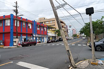 PR-35 in Santurce

Major intersections
The entire route is located in Santurce, San Juan.
| km[1] | mi | Destinations | Notes | ||
|---|---|---|---|---|---|
| 4.1 | 2.5 |  PR-1 south (Avenida Luis Muñoz Rivera) – Hato Rey PR-1 south (Avenida Luis Muñoz Rivera) – Hato Rey | Southern terminus of PR-35 | ||
| 3.8– 3.7 | 2.4– 2.3 |     To PR-1 north (Expreso Luis Muñoz Rivera) / PR-36 (Avenida Borinquen) – Santurce, Bayamón, Caguas To PR-1 north (Expreso Luis Muñoz Rivera) / PR-36 (Avenida Borinquen) – Santurce, Bayamón, Caguas | |||
| 3.0 | 1.9 | PR-Avenida José Fidalgo Díaz / PR-Calle Los Ángeles – Santurce | |||
| 2.5 | 1.6 |  PR-37 (Calle Doctor Manuel Fernández Pavía) – Santurce PR-37 (Calle Doctor Manuel Fernández Pavía) – Santurce | One-way street | ||
| 2.4 | 1.5 |   PR-22 west (Autopista José de Diego) – Bayamón, Caguas PR-22 west (Autopista José de Diego) – Bayamón, Caguas | PR-22 exit 0B; incomplete diamond interchange; eastbound exit and westbound entrance | ||
| 1.7– 1.6 | 1.1– 0.99 |  PR-2 (Avenida Roberto H. Todd) – San Juan, Bayamón PR-2 (Avenida Roberto H. Todd) – San Juan, Bayamón | |||
| 1.2– 1.1 | 0.75– 0.68 |  PR-39 (Calle Cerra) – Santurce PR-39 (Calle Cerra) – Santurce | One-way street; northbound access via Calle Monserrate | ||
| 0.0 | 0.0 |  PR-16 (Bulevar Román Baldorioty de Castro) – Santurce PR-16 (Bulevar Román Baldorioty de Castro) – Santurce | Northern terminus of PR-35 | ||
1.000 mi = 1.609 km; 1.000 km = 0.621 mi
| |||||
See also
 Puerto Rico portal
 U.S. Roads portal

References
- ^ a b Google (27 February 2020). "PR-35" (Map). Google Maps. Google. Retrieved 27 February 2020.
- ^ Puerto Rico Department of Transportation and Public Works. "Datos de Transito 2000-2009" (in Spanish). Archived from the original on 1 April 2019. Retrieved 29 March 2019.
- ^ National Geographic Maps (2011). Puerto Rico (Map). 1:125,000. Adventure Map (Book 3107). Evergreen, Colorado: National Geographic Maps. ISBN 978-1566955188. OCLC 756511572.
External links
 Media related to Puerto Rico Highway 35 at Wikimedia Commons
- v
- t
- e
 | This Puerto Rico road-related article is a stub. You can help Wikipedia by expanding it. |
- v
- t
- e


