Quản Bạ district
You can help expand this article with text translated from the corresponding article in Vietnamese. (March 2009) Click [show] for important translation instructions.
- View a machine-translated version of the Vietnamese article.
- Machine translation, like DeepL or Google Translate, is a useful starting point for translations, but translators must revise errors as necessary and confirm that the translation is accurate, rather than simply copy-pasting machine-translated text into the English Wikipedia.
- Do not translate text that appears unreliable or low-quality. If possible, verify the text with references provided in the foreign-language article.
- You must provide copyright attribution in the edit summary accompanying your translation by providing an interlanguage link to the source of your translation. A model attribution edit summary is
Content in this edit is translated from the existing Vietnamese Wikipedia article at [[:vi:Quản Bạ]]; see its history for attribution. - You may also add the template
{{Translated|vi|Quản Bạ}}to the talk page. - For more guidance, see Wikipedia:Translation.
District in Northeast, Vietnam
Quản Bạ district Huyện Quản Bạ | |
|---|---|
 | |
| Country |  Vietnam Vietnam |
| Region | Northeast |
| Province | Ha Giang |
| Capital | Tam Sơn |
| Area | |
| • Total | 210 sq mi (550 km2) |
| Population (2019) | |
| • Total | 53 476 [1] |
| Time zone | UTC+7 (Indochina Time) |
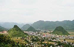
Quản Bạ is a rural district of Ha Giang province in the Northeast region of Vietnam. As of 2019, the district had a population of 53 476.[1] The district covers an area of 550 km2. The district capital lies at Tam Sơn.[2]
Administrative divisions
Quản Bạ District consists of the district capital, Tam Sơn, and 12 communes: Bát Đại Sơn, Cán Tỷ, Cao Mã Pờ, Đông Hà, Lùng Tám, Nghĩa Thuận, Quản Bạ, Quyết Tiến, Tả Ván, Thái An, Thanh Vân and Tùng Vài.
References
- ^ a b General Statistics Office of Vietnam (2019). "Completed Results of the 2019 Viet Nam Population and Housing Census" (PDF). Statistical Publishing House (Vietnam). ISBN 978-604-75-1532-5.
- ^ "Districts of Vietnam". Statoids. Retrieved March 13, 2009.
- v
- t
- e
Districts of Northeast region of Vietnam

- Hà Giang city※
- Bắc Mê
- Bắc Quang
- Đồng Văn
- Hoàng Su Phì
- Mèo Vạc
- Quản Bạ
- Quang Bình
- Vị Xuyên
- Xín Mần
- Yên Minh
- Cẩm Phả city※
- Hạ Long city
- Móng Cái city
- Uông Bí city
- Quảng Yên town
- Đông Triều town
- Ba Chẽ
- Bình Liêu
- Cô Tô Island
- Đầm Hà
- Hải Hà
- Tiên Yên
- Vân Đồn Island
※ denotes provincial seat.
23°04′59″N 104°55′01″E / 23.083°N 104.917°E / 23.083; 104.917
 | This article about a location in Hà Giang Province, Vietnam is a stub. You can help Wikipedia by expanding it. |
- v
- t
- e


